Good Saturday, everyone. We continue to hang on to temperatures that are running below normal across much of Kentucky. While temps are expected to slowly climb in the coming days, the overall pattern is sending mixed signals. There are some indications we could turn stormy later next week into the following week.
Speaking of storms… we have a few scattered about the region this weekend. Not everyone will get in on the action, but some locally heavy downpours will be possible. Highs will range from the low 80s in the east to the upper 80s in the west.
Current Temperatures


Sunday looks to feature more of the same as we await the arrival of some warmer and more humid air. That sweeps in for the first half of next week. The European Model is showing another cold front moving in here later Wednesday. That front then stalls out with cool air to our north and hot air to our southwest…
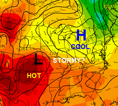
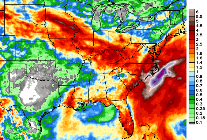
That would put Kentucky in a zone featuring rounds of showers and thunderstorms working in from the northwest. That would start Wednesday and carry us through next weekend. Here’s the rainfall forecast from that same model run…
 Like I said, the pattern is sending some mixed signals over the next week, so we shall see.
Have a great Saturday and take care.

Rain very much needed in frankfort area, the 1 inch of rain got last week is long gone! I’ll take some warmer weather in exchange for rain!
Nice soaking thundershower just hit most of frankfort, Awsome!
Thundershower? Is that just another word for thunderstorm?
Mild thunderstorm 🙂
Hail and heavy rain in southeastern Fleming Co.
Western Kentucky absolutely cannot buy a drop of rain!
Northeast radar shows storms right over us, but no rain here either! Heard a rumble or two of thunder off to the east and that’s all folks. Let’s get some rain in both ends of the state.
Driving down I-64 from Louisville to Lexington and ran into a bad thunderstorm near Frankfort. Traffic was down to a crawl with torrential rain and hail. Also had lots of cloud to ground lightning. This was really a wicked storm!