Good Wednesday, everyone. Steamy air continues to fire up rounds of showers and thunderstorms across the region. In addition to the heavy rain threat, a few of the storms could become severe and I have the blog all set to track the action.
There really isn’t a whole lot more that I can say about the week. The headlines should suffice…
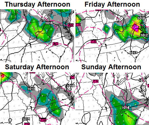
– The storms come at us in waves through the weekend and each wave will contain torrential rainfall. The greatest threat for flash flooding problems will be across central and eastern Kentucky.
– A few of the storms may contain high winds and hail.
– This is a very steamy period with high humidity levels and toasty temps.
– Daily temps will be determined by the timing of the rounds of storms. 90s will be common across the west. Central and eastern Kentucky’s temps are not nearly as clear cut. For one, there will be more clouds and storms. The other big player… a super soaked ground with green grass and lush vegetation.
Looking farther down the road into next week… the models are showing the tropics coming to life. Several of the models are suggesting a storm gets into the Gulf of Mexico.
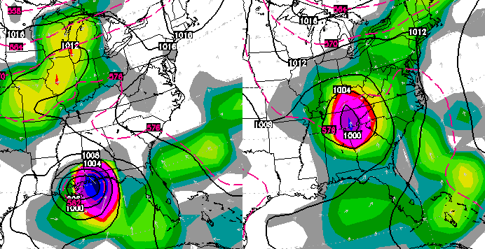
There’s a big ole grain of salt alert with that map, but that certainly wouldn’t be good for Labor Day Weekend.
Back to tracking today’s storms…


Today’s risk area

Current watches

Possible watch areas 


Have a great day and take care.

Thanks Chris. We missed the storms last night but we still got treated to a lightning show from the cluster near Campbellsville! Must have been some high cloud tops! Guess our turn will come in due time. Have a great Wednesday everyone!
We got a direct hit from the storms this morning. Left behind 0.68″ of rain, power outages and a big home over in northern Boone County was lost due to a lightning strike.
Hope we miss out on the next round…
This ought to be part of your blog tools CB…the real time lightning tracker…I think it’s pretty accurate and near real time.
http://www.lightningmaps.org/realtime?lang=en
it will be interesting to see if the storm in southern Indiana will disintegrate or fade before arriving in Louisville.
I think we knew the answer to that one. So far this past week, I’ve had all of the humidity but none of the rain. I did though just pick up now .03 inches of rain so I’ve got that going for me. Mid to upper 90’s are very likely here in Louisville this weekend since we have missed out on most of the rain.
yeah we were fortunate to get something out of this.
it is amazing how many times we get the runaround.
I hope this pattern does not continue during the winter.
While the tornado threat is quite low for Kentucky and Tennessee, some weak rotation is not out of the question; Tornado Warning recently issued for Blount County TN (Blount County is just south of Knoxville).
Lightning strikes increasing across the region…now in Jefferson county, also approaching Anderson county. Others include Shepherdsville, Bardstown, east of LaGrange, south of Carrollton
As CB Tweeted, a Severe Thunderstorm Watch now out for much of central Kentucky (and central Tennessee).
In its most recent update, the SPC now has much of central and eastern parts of KY and TN under a Slight Risk of severe wx. Strong damaging winds and large hail are the threats with the highests risks. Can’t ignore the risk of lightning strikes and some flash flooding. Tornado threat remains rather low.
Needless to say, radar is becoming very active, lots of warnings across KY and TN. Many nasty storms have popped up just east of Nashville, can hear lots of thunder but so far only wind and moderate rain at my location.
Just interesting – only got a minimal rain overnight, and looking at the rain right now – there is a split north and south of Cynthiana again…it’s that parting of the clouds we get quite often. We just got some short wind bursts, and are getting rain…but no storm.
Woke up last night to a bright room. Had to look for the light that was on for a second before the lightning actually subsided. My yard is a flooded mess from all the rain, even this afternoon.
And I am not sure why but I like rainy days. Love to just stand on the porch and listen to it for a while.
Clark county fire dept making run on 4 people trapped in elevator on 15th floor…bad timing.
100 bucks says Todd didn’t get any rain today.
Lots of places didn’t get rain today. I had a grand total of .02 inches in my 3 minutes of drizzle. Most of the Mesonet sites west of I65 show a big fat zero on the rainfall for the day. That being said, I’m glad I missed out on the power outages.
100 bucks says Todd did get some rain. Considering the storms that blew through the Lexington and Frankfort areas this afternoon.
You owe Todd $100
Serious flooding (again) in Perry and Knott co. If it keeps this up things could get really bad.. Ground is saturated to say the least..
Last night we had 2/10 inch of rain and today we had nothing. Sorry for all those who are getting walloped with storms and heavy rain. Wish the system was more equal in its distribution throughout the state. The muggy air though seems to be everywhere.