Good Sunday, everyone. Much better weather is in store for the region today and this is likely just a little preview of what’s coming our way. I’m tracking a big blast of fall temperatures coming by the end of the week into next weekend. That is likely to be the coolest air we’ve had since back in spring.
Today will feature partly sunny skies across most of the region. I say most because leftover moisture may fire up a scattered shower or thunderstorm in the south and southeast. Highs today will should stay in the 70s for a lot of folks.
Current Temperatures


Temps by Monday morning will be on the cool side with low and middle 50s showing up. The rest of the day will feature a mix of sun and clouds with the threat for a shower or storm in the east and southeast. Highs will hit the upper 70s and low 80s.
We will see a better chance for scattered storms around later Tuesday into Wednesday as temps spike back into the 80s.
That will set the stage for a powerhouse storm system to develop across the plains and work into the Great Lakes. Snow is likely on the backside of this system with strong and severe storms ahead of it. That’s something we will have to watch for by Thursday.
The air coming in behind that bad boy is VERY impressive for this early in fall…
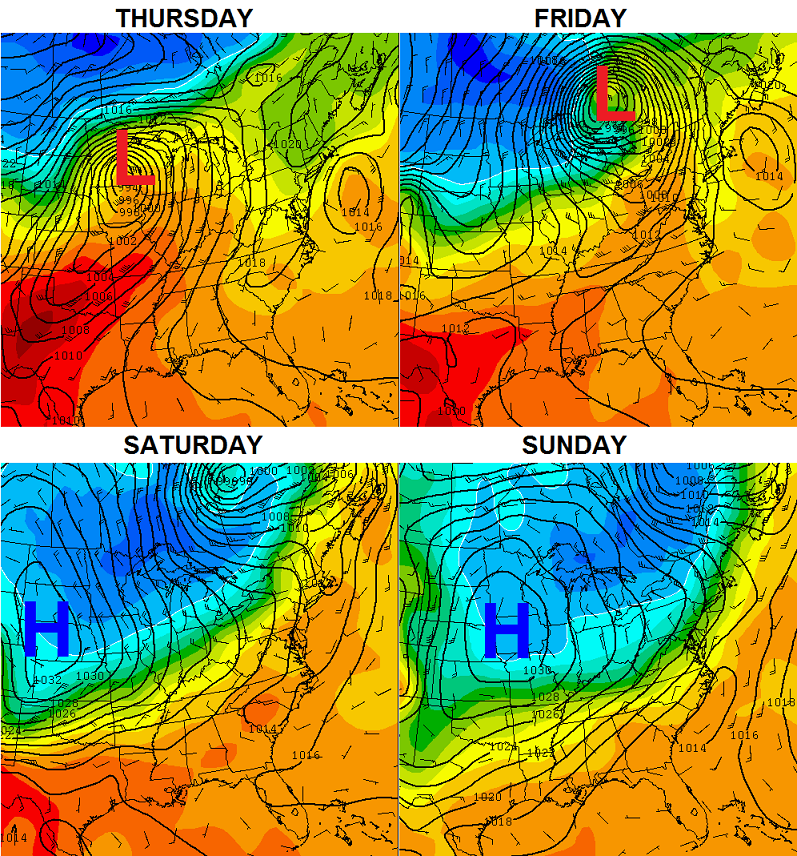 That really is a massive area of high pressure coming in for the weekend. That has the potential to bring record lows from the Rockies all the way into our region and even into the northeast.
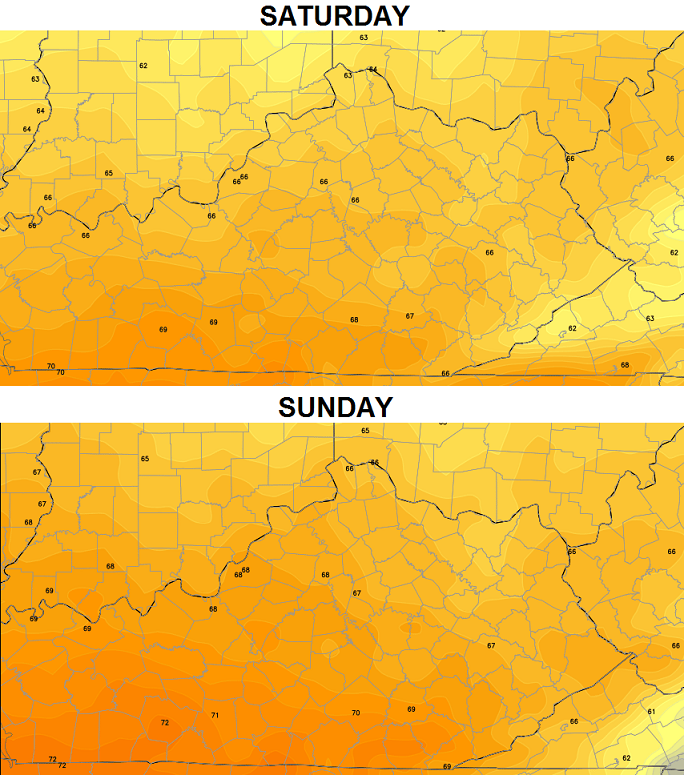
Can you handle highs in the 60s on the second weekend of September? That’s how things are looking right now…
 The cooler than normal weather is likely to stick around into the following week. I don’t think this is a true early start to full blown autumn, though. I do think this is a warning shot from our pattern. Maybe I should call it a reminder shot, instead, because it’s reminding us how little the overall pattern has changed since last fall.
Enjoy your Sunday and take care.

Love the blog Chris
How long do you foresee this year long pattern lasting?
Probably at least 50 years. Just like previous eras of low solar activity such as the Maunder Minimum.
Richmond (north anyway) did not get any of the rain moving through the area yesterday. Little if any on Friday as well. Saw the clouds all around though. Very concentrated. Especially over the Cats yesterday. It was like that rain targeted the stadium.
Nice and cool here this morning.Misting rain off and on but not enough to get very wet.Probably enough to keep from mowing the lawn today but since its cool I will do some shrub trimming and leave the mowing for a couple of days.
Gosh it feels and looks like Fall this morning.So glad to see the cool temps on the way.Can finally get a break today from the AC running.
Sounds like we may have another round of warm before it gets cool to stay.The cool I am looking forward to but I can wait awhile longer for the cold.Still have lots to do to get ready for winter.
I live in Richmond Virginia. This morning looks so much like fall,and best of all it feels like it. I’m loving the cooler temperatures!
We always stop at Waynesboro on the way to Wiliamsburg. Bet it is real fall-like there too in the mountains.
Williamsburg
im loving this cool fall like weather. Fall and winter are my 2 favorite seasons. hard to believe it can get cold enough to snow a month from now. ive saw snow flying mid oct here before, oct 2006 was one year it did. that front that came through here that year was what made me realize how good chris is at forcasting. i visited the old wkyt blog chris did back then, he said a cool down was coming around oct 10th. this was last of week in sept he was talking about that. it was oct 11 or 12th, we got the front come through he was talking about, and if im not mistaken, snow was flying out of that system.