Good Monday, folks. As hard as it is to believe, Thanksgiving week is here! Obviously, this is a big week for holiday travelers and it looks like mother nature is going to cause some big issues across the country. The issues begin today with high winds blowing across the bluegrass state.
The winds out there today may gust close to 50mph at times as a powerful cold front sweeps eastward. Scattered showers will be around as temps drop quickly from west to east.
Sustained Winds

Current temperatures


Seasonally chilly air moves in behind this for Tuesday with upper 30s to low 40s for many areas. Our weather eyes then turn toward a developing east coast winter storm for the busiest travel day of the year.
The European Model continues to nudge a bit west with the snow shield across eastern Kentucky…
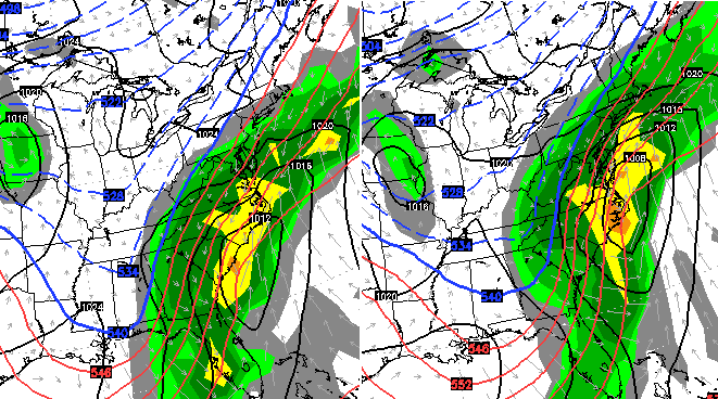
Each run of that model has been showing more of Kentucky getting in on some of the action. Let’s see if that trend continues with future runs today and Tuesday. The Euro also shows the light snow system diving in from the northwest for Wednesday night and Thanksgiving…
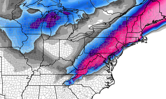
The snowfall map from the European Model clearly shows a huge disruptive winter storm across the east. You can also see some light accumulations showing up from the system coming in from the northwest…
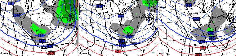
The GFS continues to trend toward what the European Model has been cooking for the past several days…

The system diving in behind that moves in here Wednesday night…
That might have just a touch of rain on the southern edge of that, but the GFS is putting down some light snow accumulations across much of the region…

Black Friday looks dry and cold with temps in the teens to start and 30s to end. We should see thermometers warm by Saturday on a gusty west and southwesterly wind. That will be ahead of an arctic front that shows up later Sunday or Monday.
The models have been all over the place with timing and strength of that boundary. A few models show this pushing into Kentucky and putting the brakes on with a wave of low pressure developing along it. The end result could be a mixed bag of weather…

I will have updates later today. Hold on to your hats and take care!

At early light here it looked like a windy, warm, Halloween sunset.
hey Bailey understand u met some fine friends of mine Saturday.
Yes sir. Some good people!
they sure r
Chris, u think if it continues to shift nw that we could see 4″+ here in eastern ky? I’m worried that temps are goin to make it a rain event during the days with snow only at night. Thanks for your hardworking and continuous updates!
Thanks Chris. Looks like you are in for a busy week for sure! Have a great Monday everyone, if that is possible. (After all we ARE talking about Mobdsy!)
Hey this is something to actually watch for. Models always do the north and west trend. Since it starts off this far south, the main band should hopefully end up somewhere in Kentucky, and whoever does get this snow, will get pounded! Northwest trend = stronger system also, the weaker, the more south. This will be fun to track…
Most though would probably be about 75 miles NW, if the usual shift happens. That does make it a potential debate if I head to Paintsville on Thursday, since Mountain Parkway is not a place to be when snowing. Nope.
Wind gust at 55mph in Hardinsburg located in Breckinridge County last hour. Here in Louisville, gusts of 49-53 mph have been reported within the past 2 hours. Power outages have been increasing across the area along with some tree and limb damage.
Wow. A major gust of wind just happened here in Valley Station. Winds must have topped 50mph. The front must be plowing through.
I’ve heard other meteorologist say the week of dec 1. We could be talking about temps in the 60s. But I think they are just posting what the models show. I hope they are wrong.
the NW trend not showing up enough to get SE/E KY
Wow are we ever having wild winds.For the most part its sustained winds.My wind chimes,wind socks,and every thing else out there is in knots.
Geesh the house is popping and cracking and the trees swaying and rocking.I am not liking this one little bit.This sure got rid of the rest of the leaves.Close to 70 degrees at the moment.Be so glad when this stops.
I hope that the weather is calm enough to allow you to enjoy Thanksgiving with your family!