Good Sunday afternoon, gang. I wanted to drop by for a very quick update before I settle in for an afternoon of NFL Football.
The pattern from later this month into January is likely to take on a very extreme look. A major period of blocking will develop across the North Pole and parts of Canada Christmas week into New Year’s week. That sends a DEEP trough across the country and it’s one that has DEEP FREEZE written all over it…
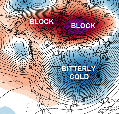
That’s one wicked pattern, folks. It’s one that will wind up much colder than my winter forecast called for… and it was already calling for a frigid January!
It’s also a setup that should feature mucho snow chances and the potential for something extreme.
Speaking of snow chances… I will be updating those with the post later today. The storm coming later this week continues to get my attention and there will be another one just before Christmas. PS… don’t sleep on the potential for a band of light snow to sneak in here late Wednesday or Thursday ahead of the weekend storm.
Have a great afternoon and take care.

Mr Bailey, I have been following you for at least a year. Live up in the north lands near Cincinnati. You do a great job and will continue to follow your thoughts. Little worried about the game with Newman and Gresham both out today.
Looking very Interesting for the MNF game at Cincy on the 22nd.
Go Broncos!!! 🙂
Thanks for all the updates!
I will be so mad if a snow storm comes while I’m gone. Lol, I will be leaving the 22nd to Brownsville, TX and won’t be coming back until the 2nd of January or so, maybe earlier. At least i will be enjoying 80° weather and beaches with thunderstorms!
Have a great time, Israel.
Perhaps a good topic to bring up among the locals is the White Christmas that Brownsville got back in 2004 🙂 . That was their very first White Xmas and also their first measurable snow in over a century!! Between the 100 years plus between the two measurable snows, there had only been trace snows and a few ice storms.
The recent tweets from CB are getting this snow lover really pumped for the upcoming week and beyond!
Hmm…travel days of the 19th and 24th are looking tricky.
Roger sees some other mets are predicting the mid-late month systems to go well south of Kentucky giving Dixie and the east coast all the fun. Roger will put his faith in the good ‘ole northwest shift! 🙂
Mike’s model says take the axis of maximum snowfall three days out and shift it 75 miles northwest. let’s see how that plays out in the next couple of weeks…
I’ve just got that feeling something big is going to happen around here, maybe not this storm but maybe the next, THIS SNOW!
I’ll be thrilled if we just a have a cold Christmas and a cold winter. Thanks so much for keeping us informed, Chris!
Really hoping the brunt of the arctic air/snowy weather will hold off until I return from Seattle on January 5. I would hate to miss a big storm while I’m gone. 🙁
Just for the fun of it, and I’m surprised CB hasn’t posted the map yet, but per John Belski’s blog on FB, the European has a broad swath of 8-12″ snow across south central KY, with 4-8″ elsewhere.
Too early for maps I think.
Feeling excited!!!!
That will give the kids their last week of school before Christmas break.