Good Saturday, everyone. A small taste of winter weather is pushing across parts of the bluegrass state early today. But, the main story of the forecast period continues to be on the potential for a Christmas Eve and Day storm system.
Today’s flakes will be early and still don’t look like a big deal, but a coating is possible for a few areas. The best chance for that should be across the southeast.
Current temperatures


Temps today will be back into the mid and upper 30s for many as the flakes wind down. Temps for Sunday will be in the upper 30s to low 40s with a mix of sun and clouds.
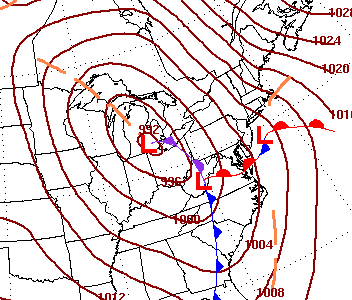
The main focus of the forecast continues to be on the developing storm system for late Tuesday into Christmas Eve. I like what the Canadian model is doing…
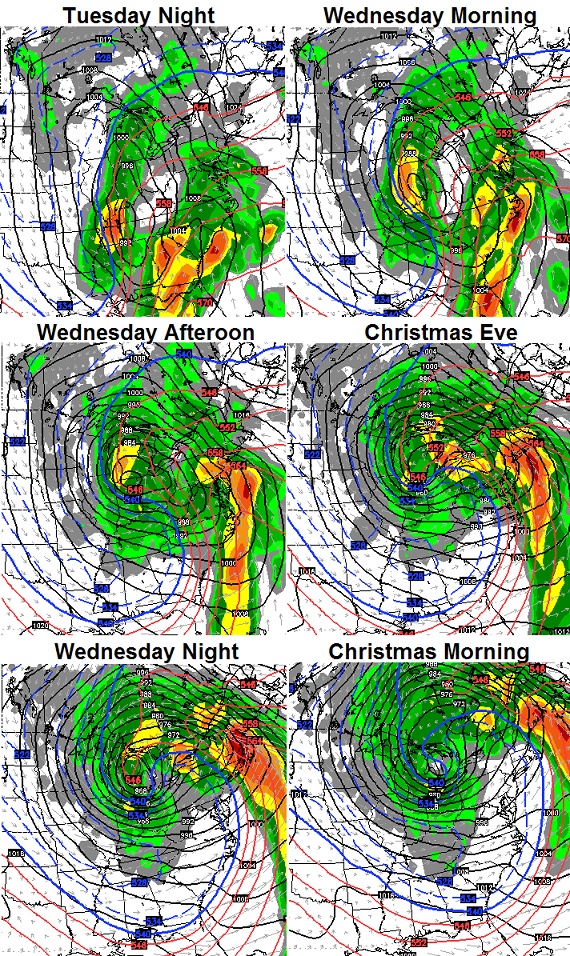
That continues to take the low right on top of us on Tuesday with heavy rain and wind. As that storm deepens into the Great Lakes, temps crash around here with a switch to some snow with snow showers and flurries Christmas Eve into Christmas Morning.
Can that scenario give us SOME snow on the ground? That remains to be seen, but some flakes should be flying around as Santa comes to town. Winds should also be super duper gusty.
The above model depiction is similar to what the folks at the WPC are thinking. Wednesday morning…
The overall pattern continues to transition into a harsh winter setup for much of the country that likely carries us into January. I mentioned in earlier posts about how the supercomputer analog years all featured big cold air outbreaks. Check out the what the models show as we wrap up 2014…
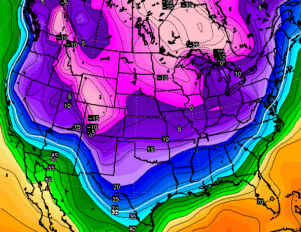 This is a very good pattern ahead for cold and snow lovers. Every system won’t produce big snows or even snow… our region should be sitting pretty on a few occasions. Several of those same supercomputer model years also featured memorable storms.
Posts today will be sporadic at best. I will tweet some thoughts.
Have a great day and take care.

Have a great time in Chi town and cheer those Cats to a win! As much as I would like to have a white Christmas, I would rather see the Cats win another NCAA Championship. Go Big Blue!
Chris woke up to a nice little coating of snow and flurries.Have a great trip.
Seems to me everyone is backing off the “storm” for christmas eve/day. Mets here (Cincinnati) are saying rain, changing to snow showers then flurries. No one is talking, “let’s wait and see .” Even Chris has changed his language with this system. Well, let’s hope for at least a nice covering for the holidays!
Heavy rain, that’s awesome!
Maybe the heavy rain and wind will hit me in the head to wake up and quit hoping for a nice snow. 7 days out is getting old already
So the trend won again it seems. Models look great for significant to big snow and then back off to the 33/32 law.
How many did Lucy get this time? Winning!
Go Cats! Go EKU too. They blew #18 Miami out at Miami last night!
There never really was a threat of a real snow with this storm. It always had the wrong track for snow and back side snow showers never amount to anything around here. There was never anything to see.
Wow, talk about the storm in past tense when it’s still a future system. You must be God or something. Nice going.
Oh, and judging by your comments, I guess nobody’s really going to get any snow with this storm, right? Except people in the far north, because…why? Look at the maps again.
Backside snow showers? Where does snow set up in a storm, on the front end? Good grief.
What is your problem Aaron? You have some major issues going on if you are getting angry over a weather blog comment.
As for this storm, it’s a rainmaker for nearly all of us. Temps are never even going to drop below freezing before, during or after. And lots of storms have snow on the front side. Not all storms are rain changing to snow on the backside.
Yes, there will be snow showers on the backside but temps are going to be too warm to stick.
Chill out, life is better when you aren’t so angry.
It’s 27 this morning. It’s below freezing already.
Got any hard proof to back up your “solid” claims here, since they’re written in such a way that nobody can argue with them? “It won’t get below freezing before during or after the storm..” right, for how long of a window are we talking here? Like I said, it’s 27 this morning.
It was below freezing here at 4 am now its 37
we need to treat the models as a football or basketball prospect.
we do not know their full potentially until they begin to play
Using words of “absolution” like “always” and “never” aren’t really wise to use when it comes to weather. This is the main problem I have with the post. The wording.
Nope, as an average they showed potential just as CB states in several posts over the past days. Just like this weekends and many before it- the models play magician- now you see it now you don’t.
The models giveth and the models taketh away. The same people get the same weather over and over again, also.
I agree. This is getting rediculous. Our weather around here as a whole stinks. Even in the cold winters we can’t get a decent snow. Not going to believe any hype anymore until I actually see the snow on the ground….geezz
Have a great time Chris, and thanks for updating even when you are off and trying to have a little fun. Can we have cold and some snow showers for Christmas? I’ll take it over sunny and 70, like we had a couple of years ago when this wacky weather pattern started! Well, this “elf” has a little more Santa helping to do this morning, before the game. Gotta go. Have a great and safe Saturday everyone and GO CATS!!!
Blowy festive flakes mixed with cold windy rain…. Sounds like Grinch weather to me, but is what it is 🙂
The news though is picking up about the systems coming in mid week. The maps show mainly rain for us, but lots of frozen stuff for other areas.
What this storm is really doing is priming us for a winter to remember. Huge warm up on the East and Northeast side of the low with very heavy winds and thunderstorms for some. Once it moves out you better get your warm weather gear prepared. As for looking at the models and getting excited about what they are showing more than four days out is what gets people hyped about much of nothing.
Thanks Chris enjoy the game. Go Cards! Although I don’t want the Cats to lose Until next weekend I just can’t say Go Ca……see.
Of course I64 centric folks would be positive 😉
Rightly so perhaps, since a likely track for the bigger snow chances 🙂
Cool! Just looked out window here in Louisville and it is snowing. Very very lightly. Like I saw about 120 flakes. Lol
Guess my reverse psychology didn’t work.
I’m dreaming of a brooooown Christmas…and windy, and bone chilling, with some Niagara Falls rain.
But, hey, festive flakes are going to make me feel all toasty and Christmasy inside.
Yay for snow globe weather. Woo hoo. 😉
For the record, from Dec. 29th to the 31st, I will be rooting against snow of any kind in Kentucky. It needs to follow me to Illinois.
Happy New Year from the Grinch that stole a White Christmas
Yep, the pattern of the last few years appears to ha e win out again. Heavy rain with left over flurries. No big deal other than high winds that could knock out power.
A few flakes bouncing around here in LexTown. Keeping the faith on some snow for Christmas. Go Cats!!!
Facebook/Lewis Rolo Roberts come be my friend and subscribe to my youtube channel!!!!
be next year before any snow.. im not seeing any big snows this season myself.
More jibberish from the Rolocoaster. Yay. /sarcasm
Really really want to see who forecasts what over the next few days. Really going to keep an eye on how the storm moves and see which forecasting stations play to their usual biases and which ones think they’re going to hog all the snow. Accuweather will probably forecast Pennsylvania to get 7 feet of snow because it’s Pennsylvania and all, and that’s where Accuweather’s HQ is also, while the rest of the country has a tornado outbreak. This is how ridiculous their bias can be at times…..
I’m still waiting to hear who thinks where any actual snow will fall with this storm, because if it isn’t going to snow any in the OH Valley, it shouldn’t be anywhere else, at least not according to the maps that are posted here.
Oh my, there are a lot of testy posts this morning…. It’s actually quite refreshing to see those of you in the northern counties complaining instead of just us in the southern counties. lol We in the south already knew this system was gonna give us the shaft…no need for hope or to complain!
Testy is right. Goodness. Exactly what I was thinking. In the ten years I have lived in the area there have only been a handful of decent snows, so I think people’s fuses are short with the current weather trends. Puts those of us who hope for some nostalgic return to childhood winters a bit on edge it seems, but goodness, everyone, should chill a bit, and enjoy the weather we do have. Gray skies. Cold mornings. At least we are not having a heat wave.
uhh the FORCAST for today was a bad miss, no mention of snow for northern ky past few day. its coated several areas. was supposed be far south.
no offence to anyone but a lot of mets have been wrong with the snow this morning ,and next weeks cousin looks like the cousin nobody in the family likes to claim
Hi all! After being gone a year to the West Coast, I’m headed home for the holiday and need a little guidance…
I’ve made it to Grand Junction Colorado and spent a few days with my “Sis”. I hadn’t planned to leave here until Monday but I think I see something nasty brewing over the continental divide. If I’m reading the “weather tea leaves” correctly will I be stuck here if I don’t get out of here today? I’d like to be back in Danville with the Grandkids for Christmas if I can make it back-I’m just looking for an optimal “weather window” across I 70. Suggestions?
Yep – another “week away”… Are the models like the potential hurricane tracks we used to see before global warming (oops – I mean climate change) took all the hurricanes away? You know – we see all those tracks as potential on a map. Some are way off and some end up being right on. We tend to focus on the ones that are the the most interesting. I wonder if the models do that? Are there many variations or scenarios and we only focus on the ones that are the most interesting?
Last year my part of Richmond had about 15 inches of snow. Perhaps three times the seasonal average for my ten years here. I remember at least a few “loaded” winters that completely washed out. I hope we don’t have that again.
Now just in case — I totally appreciate Chris’ efforts. He seems to take what the science gives him, mixes it with his knowledge and experience and gives us the best forecast around. He also gives us a nice place to hang out, be entertained and informed and to pontificate as if we, the public not Chris, know what we are are talking about.
Well, when we had a few hurricanes and tornados it was blamed on GW/CC and now there are a lot less of both they are blaming that on GW/CC too.
Manbearpig logic 😉
Sure – weather is caused by cc / gw. We all know that. At least the enlightened ones do.
There are a few people on here that need to sit back and enjoy a snickers bar or take a chill pill. If you KNOW what it is already going to do this winter, that has a not even started, then why pay a visit to the blog in first place. I know Kentucky is geographically located in an area that the weather tends to split off in various patterns. Never know what we are going to get until it happens. I myself like the fact that our entire region has four seasons each with own little twists.
Enjoy the weather it’s the only weather you got……Joe Bastardi
I thought it was a Twix bar…we need at least a 6 pack for a good thumping of snow. 🙂
Will be drinking one of those at noon today watching the CARDS! And looking at updates of course! This is as entertaining as it gets.
No snow here in Carrie of knott co this morning.
Boy he really missed the temps today … Already upper 30s in SE Ky heading for mid to upper 40s when the sun finally breaks thru. Tomorrow should hit 50 …. Already showing a warmer trend, so does this mean an all rain event next week ?
It’s all the hot air I’m blowing. It has to go somewhere. 😀
You mean we have sunlight? This has been the ugliest December I can remember.
And, yes, when winter weather happens, I’ll believe it. I would take model solutions and trash them at this point
Winter weather happened all last winter. It was not hot last winter. I did not get singed eyebrows from a blowtorch one time. I did not see giant streaks of blue and red emanating forth from that starry space. What blowtorch from yonder window breaks? I had some beans. Those are kinda hot….
The models are useless. The blowtorch cometh.
Fear the torch!
Since the Cats and warmth look to be in sync this winter, I declare this winter to be the big blue blowtorch!
Go Cats and go warmth.
Your comments are absolutely useless and holds zero amount of truth. It’s people like you that ruin this blog take your negativity and sarcasm and move elsewhere. Try Henry Marqusity page (accuweather) your blowtorch theory or comments are about as accurate as accuweathers 45 day extended forecast which holds zero credibility post all your useless weather comments there.
I predict a high of 96 on July 23rd, 2015.
Thanks Jeff, does it not beat the nuclear winter pattern we’re in-gray skies, 30s for highs with occasional cold rain?
Ok sorry Prelude, winter weather starts next week. Is that better?
First off, Not a single flake in Huntington WV this morning, not surprising at all. I also seem to detect a little less confidence about the snow threat for Xmas in Chris’ post. He says possibility and remains to be seen. I know he can’t predict exactly what will happen. I think my post about wishing for a boat for Xmas could very well come true. It also seems we are back to the scenario of pointing to next week for the real change/big event. I also can’t complain about the snow last year in my part of WV we had a decent amount, very unusual. But this year has been even more dismal than usual.
I’m sad to see that most weather outlets are forecasting 50s for highs all around Christmas day (23rd, 24th, 26th), and high 40s on Christmas. I wasn’t even hoping for snow, but I want a cold Christmas and a cold winter. It was very cold during Christmas of 2013. 🙁
I mentioned yesterday that temps were trending upward but someone shot me down. Nws in Jackson still forecasts sunshine and mid 40’s for Thursday. I’m still not convinced we’re graded for a “winter” pattern towards the first of the year. The m
I have to say the temperature forecasts I have looked at today and compared to yesterday are trending up now. Except WKYT the rest are hitting 60s Tuesday and are above freezing even for lows through Christmas. We are still some days out though. And, at least in my area, temperatures have been lower than those other forecasts. Bailey has been spot on with the colder temps.
Careful, the blog police will complain that you’re being negative and lobby for a ban. Ironic, as they can make personal attacks and its a ok.
http://scontent-a-lga.xx.fbcdn.net/hphotos-xfp1/t31.0-8/10431176_10102306487702069_7294606254951140646_o.jpg
Ha Ha..Found this on another site..
People get to emotionally involved with winter weather..Gonna do what it’s gonna do..In the mean time the Canaduam still looks like snow showers for a lot of places..better than nothing
Bring it home, CB! Even a dusting on Christmas goes a long way. I like our chances of seeing some flakes fly on Christmas. Can’t take the timing of things for granted.
For some reason my comments aren’t showing up.
Okay, if my comment is longer than a sentence, it won’t show up.
So make multiple posts quicky……lol
…or just one long sentence…
A little comparison:
WKYT Lex18 accuweather weather.com
Mon: 42-39 Mon: 52-44 Mon: 52-44 Mon: 53-44
Tues: 48-28 Tues: 57-50 Tues: 59-48 Tues: 57-50
Wed: 29-22 Wed: 50-33 Wed: 50-30 Wed: 51-33
Thurs: 30-19 Thurs: 39-34 Thurs: 42-34 Thurs: 40-34
These are what I just looked up for Lexington forecasts at this point(I am not in or near Lexington). The WKYT is definitely the coldest on those days. WTVQ is more in line with the WKYT forecast but a little warmer. Not near as warm as the others though. The national weather service site for my area seems to be in line with the warmer forecasts. Seems about the same for Lexington.
Guess we will see which way it plays. The forecast #’s seem to favor the warmer outcome. But then I have seen this situation before and things come in colder the day of. My concern is a freezing rain situation somehow sneaking in. That would not be great anytime and especially during the holiday period.
In my area of western WV when it stays cloudy, like it has been most of the month, the temps will come in lower than predicted. But the minute any moisture is mentioned, they jump up and come in higher than predicted. Just the way it is here.
Also snow seems like a longshot at best here, we don’t even have any nightly lows predicted below freezing through next Friday.
How have the temperatures been compared to forecasts about the same timeframe out?
I have been watching this more closely recently for some areas and it seems that the temps have been coming in colder in most cases. Maybe that will happen with this situation. Never know with a setup like this.
In the low 40s here in Carrie of knott co today with out sun. Seky weather is more on tune with east tn weather then rest of ky
Should play out pretty good come tomorrow afternoon. Models will come around to a deeper low that come further south along the base and rides the apps before Bombing out over the Great Lakes. Three days of a winter wonderland for all of Kentucky.
Keep dreaming… Right…I get delusional when there is lack of activity from CB…
Think Snow…
I was thinking Same thing no action from Chris means bad news
He was at the UK game. Kind of hard to update there I’d say.
Hey I don’t care where he is I know Chris if he seen a big storm coming he would thrown a tweet out or something’s he could not help his self but then again he maybe having to much fun at that game
We are going to get a lot of wind rain, and cold (behind) from this system. The only way we will have a truly White Christmas, is if Mother Nature shoots a surprise. When you look at all the models, this thing has had “cutter” written on it from the get to. Any storm that gets this wound up, will either trip over the eastern/central lakes, or run along the gulf coast like the Super Storm did in 93. Enjoy the flakes behind the front Tuesday night/Wednesday morning. It could be worse and 60 on Christmas Day. Merry Christmas all!
BAILEY BOY hob knobbing with the big boys!!! look like u r in a box seating. being great wx man has it perks in ky@!!!!
The boys at NWS in Jackson are going with warmth for this week. Near 50 tomorrow with sun. Only chance of snow is a 40% chance of snow showers wed night. Then a prompt warmup into the 40s next weekend.
Oh well, at least the cats are on fire. The year of the big blue blowtorch!
In Jan. of 1970, several of us drove to Ashland, Ky. to spend a rainy afternoon at the bowling alley. Sure was pouring the rain and was about 45 degrees. In just a little over an hour, the rain had changed to SNOW and the roads were so slick we couldn’t get back home because semi trucks had wrecked and blocked the road. We spent six hours waiting for the road to get clear. Around 10 pm or so we did manage to get through and get home. For several years I didn’t care if I ever saw snow again. Now, I’m ready for some snow, but I also hate to think of some of the problems that we can get with a big snow. Maybe we can get something on the ground but not sticking so much to the roads…?
It was pretty clear what CB said in regard to mets discounting the storm due to models over blowing warmer temps, “They are wrong”.
Originally, he did refer to this storm as a “cousin to the Jan ’78 storm”, but that was based on the models at the time. Now, based on even what CB is saying, the storm is more like 6th cousins now. Someone will get snow accumulation out of it, but it likely will be only a fraction of the state.
If it’s cold, stops raining for Eve and Day and there’s some snow flying around in the air, that’s all we can realistically hope for given the vast impacts of our various domes, rivers, and other issues (one of your mother’s is likely large enough to block it as well) (>.>)
Looked at the model runs earlier today and surprisingly it doesn’t even look like the heavier rain aspect of this storm is going to impact us as much. It looks like it’s going to form all around us and get pulled north while we stay in between the action to the west and east. Then the storm wraps up as it heads north and leaves us with departing moisture.
Less than an inch of rain or snow on either side, the way I saw the run.
12z run of the GFS for the 28th shows a swath of snow along the Southern TN boarder over into the Carolinas. Big donut hole for all oh KY, Ohio and Pennsylvania. Snow to the east and north as well. Moral of the story is to warm with rain. Pulls in the cold the the southern stream gives southern states a storm with the Ohio Valley left cold and dry.
HEY SANTA, I would be happy with snow showers and flurries for the 24-25. I’ve been pretty good this year.
facebook/lewis rolo roberts
hey there chris, the man with the plan…..hope you are having fun which i am sure you are since your cats won big today but how about taking about 5 to 10 minutes out of your fun time for some weather deprived weenies and do a quick update on next week……thank you so much my friend.
NAM and GFS both have lost the wound-up look. GFS is progressive and stretches the storm all the way up and down the coast with very little precip over Kentucky; rain or snow.
NAM looks more realistic in short range; backside N/S shear precipitation into western KY/Eastern MO, but only goes so far out. It does not show a rapidly strengthening low, either.
Haven’t looked at the Canadian.
sorry to say..stick a fork in this one..nothing to see here folks let’s move on..
Like the tweet of the NAM….that run would give The Ville some very festive flakes.