Good afternoon, gang. We have a gorgeous day going on in the bluegrass state. It felt good to get out and take a little post-Christmas meal run. Soak this up, because things turn nasty again for the weekend and that will be followed up another active weather week. This time… arctic air has FINALLY joined the mix.
The rain will push eastward Saturday into Sunday. Temps on Sunday will trend down from west to east as many fall into the chilly 30s. The real push of cold air comes late Monday and could be accompanied by a few snowflakes as it comes in. There’s a better chance for flurries or a snow shower late Tuesday…
Temps behind this will be very cold as we end 2014 and begin the brand new year…
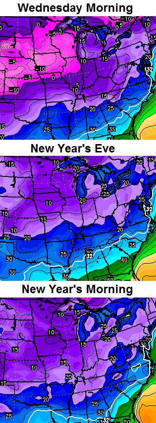
With that cold air in place, we will be watching for systems coming at us from the southwest. This is still a super active southern branch of the jet stream that will send out pieces of energy to develop storm systems. The new version of the GFS has a good look for snow lovers…
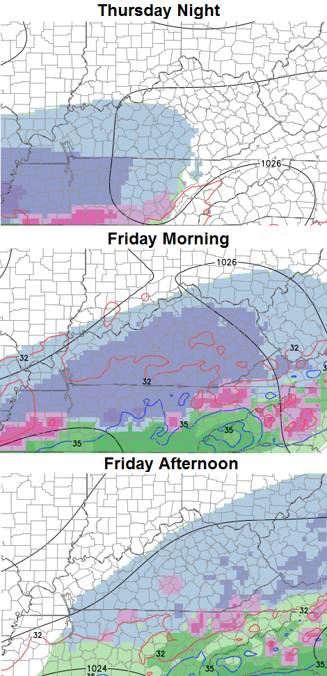
That’s what we would expect around here if we get the energy from the southwest to come at us in pieces. If it comes out all at once… that could mean a stronger storm that has a farther north solution.
I will have another update this evening. Take care.

I’m very angry at the GFS. I hope January feels and looks like January. I don’t want to see March before March ;-; Thanks for everything you do Chris, I know you wanted some snow for us for this month.
Thanks for the constant updates Chris! I look forward to them daily. Hope you had a Merry Christmas and have a safe and Happy New Years!
Thanks Chris. Not buying into any models a week out, but that does look like a good “scenario” fpr snow lovers, especially for those us in southern and eastern KY. We shall have to wait and see.
I’m watching that one closely. My concern is how far out it’s been, because the models have been struggling with consistency lately, BUT, I like the set up we’re entering. I’m thinking it will deliver in the coming weeks.
Thanks, CB! Hope that pink on the “new generation” GFS map does not pan out, as even many winter lovers disdain ice. But as CB and veteran posters would point out it’s just one run of just one model, and we are still a long ways out.
Yawn. Another model showing snow a week away that will disappear the closer we get. Has been the story for the last 2 months.
The last 15 years
Beat Kentucky.
Not gonna happen.
Blah, models have been junk. This feels and acts like the infamous winter of 1991, I don’t think we had more than a few inches of snow that season.
This is a blowtorch winter
Go cats, it’s about all we have this winter
Nasty, huh? Isn’t that what we want? A little bit of nasty. Such a negative word for the seasonal turn. Anyway. The sun is nice, but it is a bit depressing this time of year. It’s about time we got socked in for a few weeks. The cold looks like it is for real. I am curious if we get snowfall or just snow flurries.
Hope everyone had a Merry Christmas. The models are fools (snow lovers) gold a week out, they have been terrible worse than usual this year. I think we are on pace to have one of the least snowiest Winters ever in the Eastern third of the country, except Buffalo NY. Local forecasters here in Western WV have pretty much wiped out any mention of snow in our 7 day forecast and even trimmed back the cold, high temps next week are all predicted to be 38 or higher, hardly artic and certainly more conducive to rain….as usual.
stronger storm equals rain
Until the PNA goes positive we will be on that 32/33 line for most of KY. I think far west and north have the best shot of snow for the forseeable future. Thanks for the update CB. Ok Models third time is a charm. Get it right this time will ya.
stronger storm and more northern equals rain ….33/34 degree rain ….which is the trend around here ..
Frankfort had 3.5. Inches of snow in November, wonder if that will be the biggest of the year?? That would be rare I would guess?