Good Friday evening, gang. No changes on the evolution of the pattern this weekend into next week as arctic air fights back into the country early next week. That arctic air is being pushed by a 1060mb high pressure. Wow…
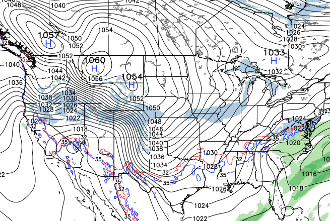
That is a MAJOR change from what we’ve been seeing over the past month or so and is an indication of a very cold pattern developing. It’s also likely taking us back into a pattern to where the models aren’t cold enough with what they show.
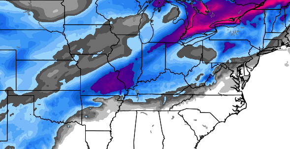
Can we get some snow and winter weather with the cold that comes this week? The time frame to watch is the end of next week. The new European is in and shows where it THINKS winter precipitation falls…
 See you back here tonight for a full update. Take care.

so u take the European model …add the northwest trend….not a trend, a fact ….and ur back to the cold rain scenario ..until that trend , I mean fact, is broken , I ll bet on that
I’m with you, I’ll take the over on the temperatures and under on the snow.
I am with you on this one. Still think this is going to be a record year for least amount of snow. We are almost through the first full month of Meteo. Winter. And only a couple flurries in my area. It is always dry/cold or moist/rain.
Richmond would pretty much have to not get any accumulating snow, so a very low bar to break.
Bag humbug says the Snowmizer!
Here we go again, a week away!
Unlike the previous week away model outlooks, I think even CB is less optimistic with them as the weeks progress. He is a trained met, but also knows a trend of overstatements when he sees it 😉
GFS south…Euro North…few hours apart and a week out. Hhhmmm
The main thing to remember here is to not get your hopes up and then be upset when these week out models ALWAYS turn sour. We will either get a big snow this season or we won’t. Either way, these models aren’t going to be accurate more than a day out if even then. Mark my words now….if we get a big one, it will be by surprise.
Hence the Charlie Brown , Lucy analogy.
Yikes – We better get LD and Bryant on here for some optimism.
Make it a good weekend all!
What a bunch of negative Nancys. We are still above normal for snowfall for the season, although the gap is closing fast. We had 5″ or so in Northern KY where I live in November, mid November at that, and we hit lows around 10 degrees. The pattern relaxed, and now its trying to build back.
You know Winter is in trouble. When I see two of my neighbors here in Huntington
Huntington WV grilling out the day before Christmas and also today.
I don’t even pay attention to all the week out stuff anymore. If it surprises me & snows, then I can really be happy!
Must be needing web site hits. Here we gonwith the week out stuff.
And here you are! Thanks for the hits.
🙂 Good one, CB!
Bubba sucking up..lol
Oh Chris, its known that you bait your readers and Jim is the real Met!
Rodger not getting excited til the snow flies!
This (sad but true).
please follow my blog as well. good accurate updates! thanks!