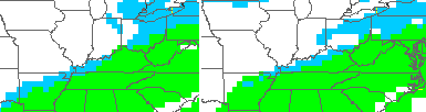
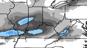
Good Sunday, everyone. Our weekend is wrapping up with a cold rain working across the bluegrass state. This continues to show up on the leading edge of a major pattern change across North America. It looks nothing like what we’ve had for most of December and, instead, it looks more like what we had back in November.
A potent cold front is slowly working across the state today and is knocking our temps down pretty quickly. Many areas should drop into the 30s as the day wears on. The latest GFS is even hinting at a brief period of light snow on the back edge of the rain shield this afternoon and evening…
We will have to see if that is indeed picking up on something, but that was the trend last night behind the front to our west.

Current temperatures

Monday will feature temps in the upper 30s and low 40s with cloudy skies and the slightest chance for a drop or some flakes.
The models diverge quite a bit late Monday night into Tuesday. That’s when the NAM develops another wave of low pressure just to out east and brings a period of light snow to central and eastern Kentucky…
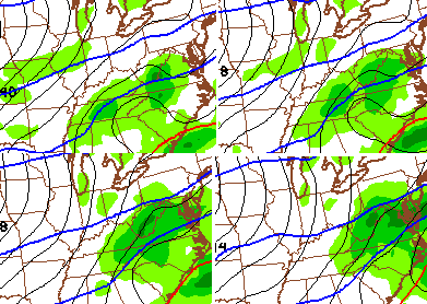
 The NAM is all alone in showing that scenario as the other models have that much weaker and farther east.
The cold for the final day of the year means temps in the upper 20s and low 30s for highs with readings dropping into the upper teens and low 20s as the ball drops on 2015…
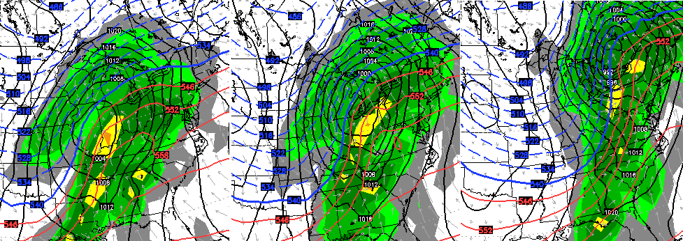
That brings us to the end of the week and trying to figure out what happens to all that energy digging into the southwest. With so much arctic air across North America and so much energy in the mix, the models are all over the place. The current line of thinking is that we a lot of that energy to come out at once with a dynamic storm system. With low-level cold air in place, overrunning moisture could lead to a little bit of everything Thursday night into Friday.
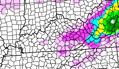
The European Model shows where it has winter precipitation falling on Friday…
Maybe some ice with that for some areas?
If all the energy does come out into one main storm system, that mess would change to rain late Friday into early Saturday. The European Model shows that setup well…
Those images are from Saturday morning through Saturday evening. You will notice how quickly the cold air comes back in here from west to east.
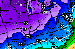
That is followed up by a true arctic cold front that unleashes a brutal air mass on the country. The leading edge of that is just getting into our region late next weekend. Here’s the European Model…
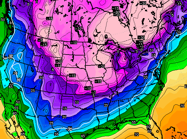 The GFS is even colder for the exact same time…
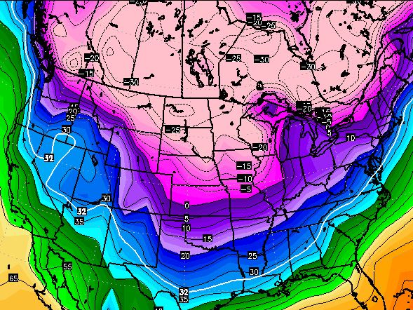 Again.. this is a total reversal of the horrible pattern we’ve been in for much of December. Think of the upcoming period as this November on steroids. 🙂
I will update things later today… for real.
Have a great Sunday and take care.

Me see single digit’s in the not too distant future…Hope the models are wrong..Nothing worse than cold and dry..25* and snow please..
According to the NWS out of Louisville this next weekend storm may produce a solid inch maybe inch an half of rain. That would be storm number 4 or 5 that the models show potential (or storm of interest) and once again became a predominant rain maker.
Snow drought continues, not only for us alot of the Midwest.
As far as snow, this could be a Seinfeld winter. A lot of talk about nothing. Love the show, but not for weather.
Need a change in programming! 🙂
Well that just may play to our advantage. At least they are calling for rain and not snow a week out. LOL
Thanks Chris. Bring on the cold & snow!
Thanks Chris. Sounds like we will need to break out the long johns! Hope I get some new ones for Christmas! ( we’re having ours tomorrow.)
Thanks Chris. Sounds like we will need to break out the long johns! Hope I get some new ones for Christmas! ( we’re having ours tomorrow.)
No idea why it posted twice. Sorry. Was also going to say gave a great Sunday everyone.
another big storm with lots of rain and some backside flurries…im sensing a theme already this winter…
That scenario would lead to all the southern branch systems being suppressed to our south. The “sweet spot” for overrunning moisture simply never sets up here anymore. We will be cold and we will be wet, just never simultaneously.
Hence the Kentucky formula = 33/32 Boo!
I rarely if ever leave comments, but it’s an interesting time. According to Weatherbell and Chris Bailey, the cold is on the way after a month long hiatus. On the other hand, DT at WxRisk has basically written off January until late in the month because the MJO is forecasted to be in phases 4, 5, and 6 and there is no 50/50 low to knock down the Southeast ridge.
I’m a hobbyist at best, but I’m surprised the warm has hung on so long. The SST’s in the Pacific favor a much colder and snowier pattern. Warm water in the Gulf of Alaska along with a Modiki setup in the central Pacific should be great for our region. Actually, the Pacific looks a lot like it did last year as well when the winter was nonstop. So what gives?
Like others, I’m more than a little concerned the cold is always 7-10 days off. Right now, the MJO seems to be trumping the SST teleconnections.
Quite frustrating to say the least.
Will be interesting to see how it plays out. I think the Louisville Mets have written the next 7-10 days off as well. All have only 1 day with a high below freezing and lows never below 20 degrees in the 7 day. That’s certainly below normal but nothing out of the ordinary for last week of December and first week of January, the heart of cold weather season.
I’m giving it till about January 20 and if it hasn’t shown signs of snow and sustained cold, I’m officially ready for spring and digging in the garden. I’ve had enough of cool, cloudy days with rain and more rain. Either snow or lets get on to spring and warm weather.
You. need. to. post. more.
This place is so much more fun to read when it has scientific discussions and doesn’t resemble a Facebook page full of Likes.
“The SST’s in the Pacific favor a much colder and snowier pattern. Warm water in the Gulf of Alaska along with a Modiki setup in the central Pacific should be great for our region. Actually, the Pacific looks a lot like it did last year as well when the winter was nonstop. So what gives?”
This could be your first published paper if you figure it out. 🙂
Maybe the first place to look is at something that isn’t supposed to have a major impact but yet might be underestimated?
My guess is the Pacific Jetstream is just so strong that it’s overwhelming the SST’s. The MJO has really been the best predictor this month, but some of the forecasts show it moving into phase 6 by the 20th. Those same forecasts also indicate it could have some amplitude and that would mean a prolonged run in phases 6, 7, and 8. Still, that’s three weeks off at best.
What exactly are the phases you are speaking of?
Phases 6, 7, and 8 of the MJO are very conducive to cold and snowy weather in the eastern US in January and February. By contrast, phases 3, 4, and 5 signal warm weather.
If you watch the latest video by DT linked on his FB page, he discusses the MJO towards the end.
From what i can tell Euro has us getting to phase 6 after Jan 7-8th..Interesting enough Models are hinting at something in this time frame..
In rereading what I wrote, I need to clear something up. Phases 7, 8, and 1 are the cold phases of the MJO. Phases 4, 5, and 6 are warm phases. I typed too quickly and made a mistake.
Good post/discussion….been posting/lurking on americanwx forums for many years and also rarely post. Chris does a great job, but this is just a tough year for the models as most of the setup points to a harsh winter, but winter has not shown up yet. Unless we get sustained blocking in Canada this fast flow will continue and now the dreaded SE ridge is showing up. We got to get the MJO closer to phase 7 and slow the pattern down via a block. Some have discussed on other forums that the
QBO is too negative and a higher level of solar activity is having a impact on blocking…both of which should be on the decline. I tend to think it is a combination of being in a warm phase with the MJO and a weak El Nina. As we move into late Jan we should see a very harsh wintery period as both move into more favorable positions.
It’s also a lot more fun to read when there aren’t wannabe meteorologists around to nitpick for the smallest chance to rip on Chris.
Gah! Chris uttered the dreaded “I” word…
Thanks CB for the update!
Without a snow pack to our north west these storms will continue to track to the lakes. So until then we will have dry cold snaps that are short lived. If the cold air can dig as deep, as some are saying, then we would be in line for potential snow. I am still thinking 1978 is the best analog year to look at for mid January into Feb. If the cold air does not dig in then we could be looking at a very wet January. The precip will be there, but will the cold?
To all of our fellow friends in northern KY, we in southern and eastern KY would like to welcome you to the club. Founded some 15 yrs ago, the 33\32 no snow\all cold rain club was founded and still growing stronger with more members every year. Welcome to our world folks and learn to enjoy it! 😉
Since Chris mentioned the ice word it looks like the potential is there for a major Ice Storm across Southern Texas going NE into the Tennessee Valley..How far NE i guess is our concern???..Will be interesting to see how this unfolds in the coming days..
Ice in the Tenn Valley would be a good thing for most of Kentucky.
The year without a Winter rolls on. For about a month now artic air has been a week away. As we get closer it gets pushed back a few more days. Pretty soon we will run out of Winter. Let’s face it last Winter was a blessing, this Winter is a curse.