Good Friday, folks. A taste of winter has returned to the bluegrass state with a fresh blast of very cold air and even the potential for a few snowflakes. This continues to be part of a supercharged weather pattern that shows little signs of going away anytime soon.
Highs today will reach the upper 30s and low 40s with gusty winds and a mix of sun and clouds. The south and west will be a little “warmer” with middle 40s. A weak disturbance will cross the area and could produce a rain or snow shower through the evening. Track whatever shows up…


Saturday morning starts with upper teens and low 20s with a partly cloudy sky. The afternoon will look good, but won’t feel that nice with highs only upper 30s and low 40s, again.
Sunday looks better with highs reaching the 50s on a very gusty wind. Clouds will increase and some showers may develop Sunday night and carry us into Monday…
Temps will be on the chilly side with those Monday showers.
Tuesday into Wednesday will find temps on the increase and could reach the 60s and could even flirt with 70 at some point. That’s ahead of another cold front that pushes in by Thursday with another chance for rain…
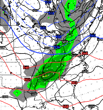
Temps after that may really take off with some 70s by the end of the week. That big surge of warmth is ahead of an increasing for a big storm to roll across the Ohio Valley over Easter Weekend. Here’s the European Model…
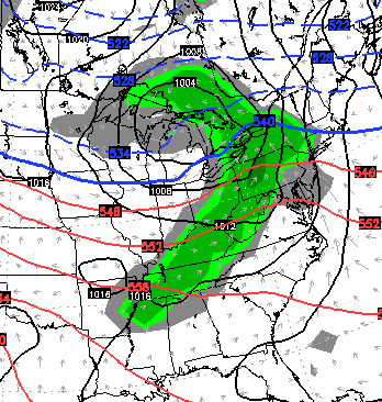
The GFS is even stronger with that storm…
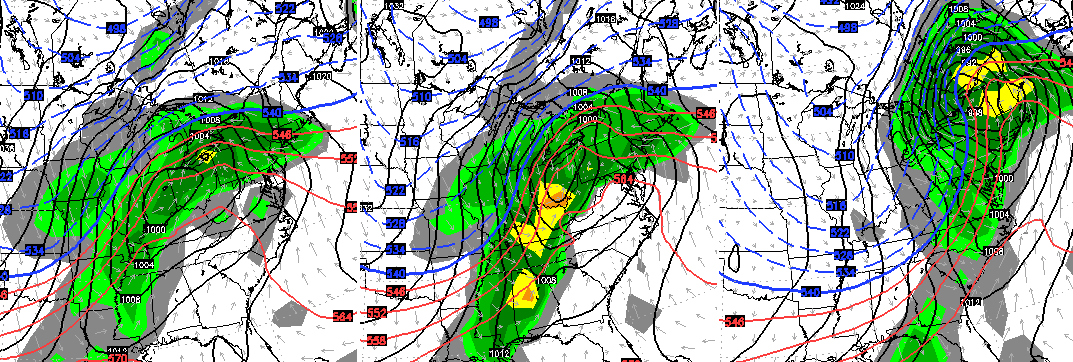
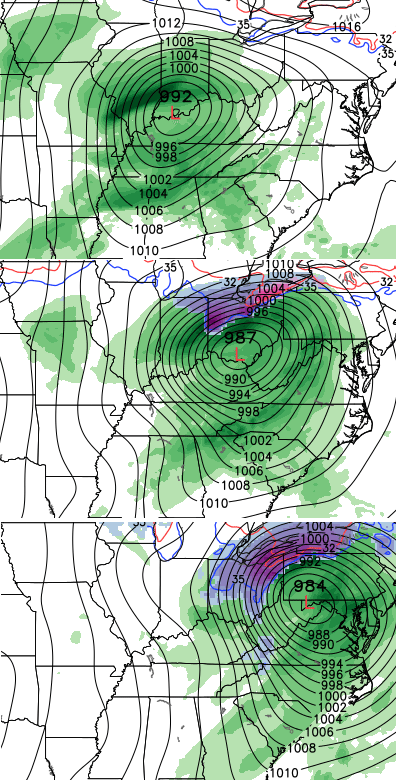 This is a very healthy signal for a major area of low pressure. Depending on the track of that storm… severe weather could be a possibility. Keep an eye on it.
Enjoy your day and take care.

So sad to see Moore, Oklahoma be hit by a tornado again 2 years later! Moore has been hit many times by tornadoes, so much that Moore, OK could be considered the tornado capital of the world! It is like the heart of tornado alley of all tornadoes.
It looks like severe weather season and full on spring is taking place. Spring= Big temp swings, severe weather, snow, heat, windy, etc.
Beat the Wolfpack!
Thanks Chris. Been a busy Froday at work. Just now getting the chance to comment. We did make it into the mid 40s today. When I went to lunch it was 46 and partly sunny. Not so now…37 and cloudy/windy. I want spring back! And with next weekend the anniversary of April 3, how ironic that we may see severe weather. I hope not. Have a great evening all.
Thinking spring now! I can’t believe the park I grew up going to “Carowinds” got this ride. OMG!!
http://www.youtube.com/watch?v=RdJH7cnQPkM
My point click forecast showing 22 tonight and 17 tomorrow night.. **rolleyes**