Good Tuesday, everyone. We have some very nice weather rolling into the bluegrass state over the next couple of days. Sunny skies and very mild temperatures will rule the roost before thunderstorms ramp up for the end of the week. The storm season is off to a very slow start, but I’m seeing signs of things rapidly increasing over the next few weeks.
Temps today and Wednesday will generally range from the upper 60s to low 70s under partly sunny skies. A few middle 70s will be possible in the west and south.
The threat for scattered showers and thunderstorms will increase for Thursday as moisture surges in from the southwest…

A decent storm system will develop in the plains late Thursday and work into the Ohio Valley on Friday. That will bring widespread showers and thunderstorms to our region…
 That could spawn some strong storms and that’s something for us to keep an eye on rolling forward. Chillier air comes in behind that with 50s showing up for Saturday. Easter Sunday continues to look pretty good with highs returning to the low 60s under a partly sunny sky.
The following week may look and feel the part of May with very warm temps and the potential for rounds of thunderstorms. The upper flow for next week will feature juice coming out of the Gulf of Mexico with a stout upper low swinging into the plains states…
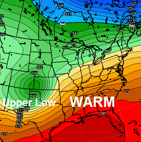 Don’t be fooled into a false sense of severe weather security because of the lack of thunderstorms, so far. I’ve been doing some spring and summer research and many years I’m looking at came on very strong later in the season. Combine that with the look of the pattern and I firmly believe busy times are ahead of us.
Have a great day and take care.

I do have to admit that I love tracking storms almost as much as I enjoy tracking snow. But, I do hope that our part of the world can escape the stuff that causes harm to people and property. Looks like interesting times ahead for sure.
I like tracking storms as well, even if there are somewhat mixed feelings in doing so. Sure, it’s fun watching the dynamics come together. But there is also the side of refreshing one self on tornado safety rules, I and other NWS Storm Spotters getting prepared to possibly send out alerts that could save lives, etc.
Considering that there have been harsh tornado outbreaks on Palm Sunday (1965, 1994) and Easter (especially 1913, including Omaha), this has been a relatively easy spring so far. The first tornado fatality of 2015 only happened a few days ago (an EF2 near Tulsa). But as Chris touched on, there are some signs things may get jumping the rest of the spring. This is regardless if this season still ends up having below average tornado numbers when including the very slow start so far.
I’m glad April isn’t starting cold as was alluded to not so long ago.
No cold or snow until next winter, which around here is mid-Oct it seems.
It’s a strange time to be alive. I never thought that UK could ever exceed Duke in national hatred.
http://youtu.be/D_aQupiaCSA
Let’s hope AT&T never find out about Rex Chapman’s hammock made out of stolen Apple products.
Sure is windy today, or at least at 10 mins after 1 its very windy. Warmer temps felt pretty good.
thanks Bailey as KEENELAND OPENS u bring in the rain..argggggggggggggg..lollllllllllllllllllll
I would like to give kudos to NWS in Jackson for their forecast discussions. As I have traveled to different locals hunting, I check the NWS forecast discussion for that area as well as the forecast. Most are pitiful and some seem not even to want to mess with it. Just checked for my weekend trip to Celina, Tn……(Nashville) it was worthless.
Agreed. I check the Jackson discussion a couple times a day.. Everyday.