Good afternoon, folks. Colder winds are now blowing across the bluegrass state as temps crash from west to east. The seasonal cold over the next few days is just the opening act to the return of winter. Things get cranking early next week with bitter cold and snows on the move.
For the past week, I’ve been highlighting the period of February 7th-11th for harsh winter weather to return to our region and the eastern part of the country. The upper air charts have been all over this, and continue to be. You cannot get a trough of this depth without some harsh stuff…

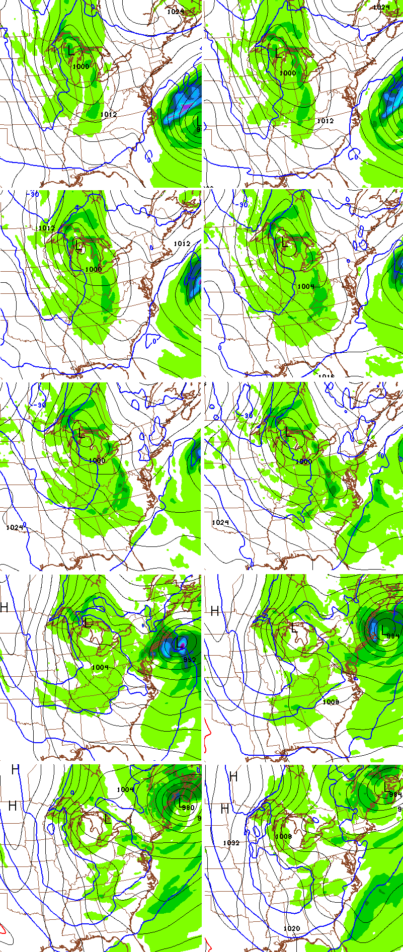
The surface charts are slowly catching on to all this. The latest GFS suggests waves of windy snows as bitterly cold air sweeps in here. The below maps are from Monday through Wednesday…
With such cold temperatures, it doesn’t take much moisture to produce snow, and those temps are brutal. Over the course of 3 days, that’s a setup that can potentially deliver a few to several inches of snow in some areas.
There’s a good chance we are looking at some snow days next week. Hear that teachers and kiddos? 🙂
Lows from the GFS with clouds and flakes…

There’s another surge of arctic air that may follow that up by next weekend with an interesting possibilities showing up coming out of the southern branch around the same time.
I will have another update later today. Make it a good one and take care.

Thanks for the heads up Chris. Don’t want snow for Monday night/Tuesday! After I get back from the Dr. in Lexington on Tuesday, it can snow all it wants to! Oh well, guess it will do what it does and we will both deal with it!
Wishing the best for you at the doctors, Coffeelady.
Your positive spirit always brings a smile to my day.
Thanks retro fetch. I appreciate that. I am hoping I can finally get some answers about these darn feet!
Seriously, I should never try to post here when I am manning the phones at work! I managed to get two conversations mixed into three sentences (boy is my face red!)
Sorry about that…
I still don’t see it. A couple bitterly cold dry ankle biters blowing around. Hope I’m wrong. Wondering if I wasted money on the sleds and snow boots. Thanks Mr Bailey
I read this blog for a reason. I live in Shepherdsville and the weathermen, around here, were calling for brief cooldowns, with warmer air (50`s) following them. Where Chris has been calling for a possible bitter cold time frame.
Tim, you are a smart man! Chris’ track record speaks for itself.
Chris, do the GFS temp map numbers represent actual surface temps forecast? Single digits everywhere?
Hey Chris, What is your long term forecast for the rest of the winter?
Please tell us there is more snow to play in coming!
http://www.hurherald.com/cgi-bin/db_scripts/articles?Action=user_view&db=articles_hurherald&id=62710
This site is calling for 2 feet of snow Friday??? Is that true
thanks for the update. This doesn’t look like its going to be a severe winter this year. I’m fine with that. Knox co. got a decent snow in January, a nice warmup to start to February and a couple of cold weeks coming up. I’m fine with spring getting here when it’s supposed to.
What is the time frame for the snows next week? Sun, mon, Tues? Or later in the week?
I could be wrong. It looks like it will be Tuesday night into Wednesday and also next weekend. Let’s wait on Chris for his expertise. He’s rarely wrong. 🙂
cool
Looks like Valentine’s Day night into the 15th looks huge!