Good Friday, folks. We have some very nice weather pushing into the commonwealth of Kentucky over the next few days. That bodes well for those of us who would like to get outside and enjoy our weekend. All of this changes in a big, big way by Monday as winter weather returns to the region.
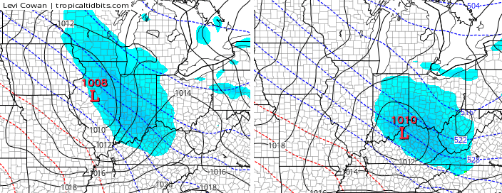
This return to winter has been well telegraphed for a while now, with a deep trough digging into the eastern part of the country…

There’s a lot of energy dropping into our region and that means we have waves of snow squalls and snow showers coming Monday through Wednesday. Some of the latest model runs are now introducing a clipper system into the mix for Wednesday into Wednesday night…
Over a 3-4 day stretch, anywhere from an inch or two to several inches of snow may fall where you live. I would like to get more specific, but that’s hard to do until we can see how each of, the many, pieces of energy play out.
The Canadian Model snowfall forecast through Thursday includes the clipper, but is based on a 10-1 ratio…

Again, don’t get caught up in snow maps from this far out. This is not a true storm, but a several day event where we get waves of snows pressing through here. The best chance for accumulations and some snow days looks to be from Tuesday-Thursday.
Looking at the next two weeks on the individual members of the GFS Ensembles from WeatherBELL, we find an active pattern continuing…
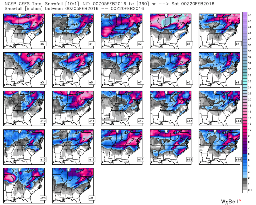
I look at this pattern and wonder if we are setting ourselves up for a big overrunning system around the middle of the month.
Updates later today. Until then, enjoy your Friday and take care.

U mean a possible ice storm when you say over running event?
Happy national weather persons day!!
Has anyone heard of a sundog???
Yup. It’s a halo around the sun I do believe
Almost…it actually appears as a partial rainbow on either side of the sun, since the sun’s rays are refracted through the ice crystals of the high thin clouds.
Doesn’t look too promising to me. A couple of dusters and more of an annoyance than anything. One 6″ or more storm to round out winter and put the sleds to good us would be nice. I’m thinking it won’t be this series of hits. Perhaps the middle of the month? I just have a feeling we are about done with snow, we will hang on to the bitter cold train and then transition to Springz
Meh.
Stay positive Clyde stay positive. I would rather it be cold with a snow globe affect rather than cold and sunny.
This is true. Just not liking our snow chances for the future. I’m thinking the sled and boots were a bad purchase, the blog can blame me if it doesn’t materialize! I jinxed us! By the way, snow globe, yes. Annoying ankle biters, no.
So basically a bunch of annoyances that’ll be of the 1-2 hour delay variety.. nothing to see here.. bring on spring!
I agree with you Dj, let spring arrive early. I have always heard that the “ring” around the moon in winter means snow is coming. The larger the ring, the more snow we get.
Wasn’t GFS hinting at just such a “big overrunning system” a few days ago? A strong southern system that throws a ton of moisture northward resulting in a huge blanket of pink and magenta stretching from Louisiana through WVa?
ICE ICE Baby….It will come back around. Might be a rain system for us, but it will show back up.
Agreed more a chance for big ice than snow. We could hope more sleet than ice rain 🙂
Three big snow storms for Richmond in less than a year. Other areas can have the next one 🙂
If there is a next one, of course.
Liking the looks of next week. Hope the cold can hold on for the rest of the month into March. The southern system will get active again. Remember the pattern repeats itself through the winter and early spring months.
Enjoy the snow globe next week, winter weather fans! Nothing obvious for a big snow after that. Any prolonged cold is questionable now. Rodger in Dodger!
I hate this setup on Monday. Rain showers rapidly turning into snow showers as temps crash. That has a flash freeze scenario written all over it.
From latest Jackson NWS discussion
HAVE UPDATED THE LONG TERM PORTION OF THE FORECAST TO REMOVE RAIN FOR ALL OF TUESDAY AND TUESDAY NIGHT…AND MOST OF MONDAY NIGHT. FORECAST SOUNDINGS DURING THIS TIME SHOW THAT PRECIP WILL BE SNOW DUE TO COMPLETE LACK OF ANY WARM AIR ALOFT AND SURFACE TEMPS BEING
NEAR FREEZING OR COLDER.
This is really a crucial time frame for our show chances. I know we’ve had a few late season snows, but average highs make the chances of seeing snow unlikely here in a few weeks. We hit 50s for average highs here in about 10 days in the southern Kentucky, so lining up the cold and the moisture takes a lot of luck. I’m okay either way. Would be nice to get one more decent snow, but I would trade it for a week of 50 + degrees and sunshine.
Thank you Chris! Have a great day;)
This about the same people that talks negitve about the last snow storm that we actually got. Think positive people!!!
Hopefully this will leave everyone with deep snow
Did you get on with the snowstorm? I moved north of Cincy and we got 2″ for the season so far. I’m past ready to move back to Corbin. Miss it.
Irony, since most of the big snows have been north of Lexington and into Ohio for the past 17 years- pre 2015.
18z likes our chances for snow
No midday update? I guess the snow is canceled!
Some of you make me laugh, thank you
Is anyone else getting frustrated with this weather..lol..I missed out on the big snowstorm back in January… And just waiting hopefully to get some snow soon…