Good afternoon, everyone. Our Winter Storm THREAT continues for Sunday and Monday. Snow develops from west to east on Valentine’s Day and continues through Sunday night. From there, we wait to see what happens with the Monday-Tuesday part of the storm.
Confidence is high with the Sunday-Sunday night portion of this winter storm. A few to several inches of snow will be likely across Kentucky. Here’s my new call for snowfall and it’s similar to the calls I had out Friday on WKYT-TV…

This is a healthy snow for the entire state with an area that can find totals nearing half a foot. Keep in mind… that’s just through Sunday night. Given my thoughts, I think a Winter Storm Watch should be up for parts of the area…

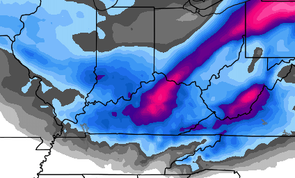
The latest NAM snowfall forecast looks similar to my snow map…

The NAM and European Model have been the steadiest of the bunch in recent days. That trend continues. Here’s the European for tomorrow and tomorrow night…
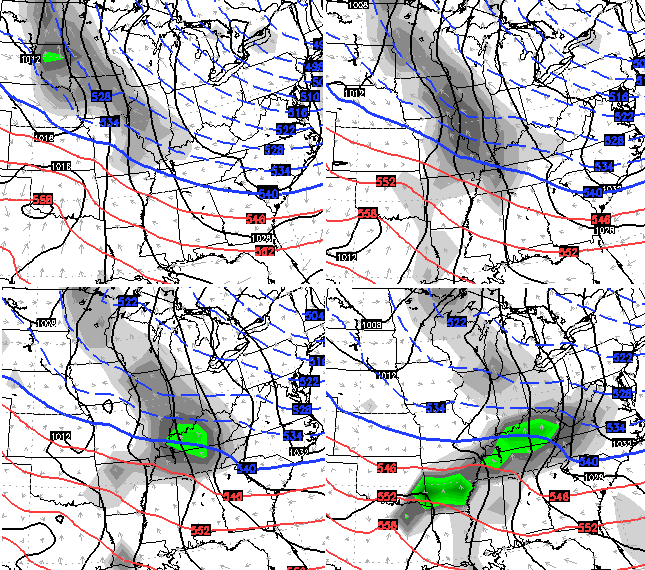
The same run of the European Model for Monday into early Tuesday ramps up the low across the eastern Tennessee Valley…
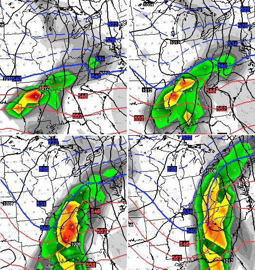
While the model does suggest rain for a time on Monday(especially south and southeast), as the low gets cranking, it drops temps in the heavy band of precipitation. That would indicate a swath of heavy snow somewhere on the backside of that low. You can see where that run thinks it sets up on the WeatherBELL map…
In a setup like this for Monday, it’s really either snow or rain or a mix of the two. Ice is not a big concern I have, nor does it show up on the models.
I’m still not confident on how Monday and Tuesday play out… hence why I only gave a snow forecast through Sunday night.
Then I see this from the UKMET for late Monday and Tuesday…

I will have another update later this evening. Until then, it’s another helping of your friendly weather trackers…

Take care.

Thanks Chris. I think other weather outlets really wait to see what you say before they make a call ;). So if YOU go ahead and call a wsw, they likely will as well. (Well it’s an explanation anyway! ).
I believe that particular euro snow map has the low tracking over the Appalachians, has that ever happened before
All the time
So, is that UKMET map showing all rain for us? That stinks
No I don’t think so.
Thank you.
How funny! Se Ky. has a winter weather advisory while Campbell County Tennessee to our south has a winter storm watch?? go figure lol
Different forecasters see different results. I don’t see anything other than an advisory needed
The Morristown,TN NWS means business. They are more often right on target with the forecasts for their coverage area, unlike Jackson. I watch the forecast for Harrogate, TN which is directly across the border from Middlesboro. That is the forecast that will be much closer to accurate for Middlesboro than the Jackson forecast for here.
Tennessee is gong with the same overall forecast as CB though with a good 3-6 inches by Monday morning with a ruin with 40 degrees and rain later. I think Tennessee being further south is just a little more sensitive when issuing winter storm watches, although KY does sometimes for the same amount forecasted.
Definitely a disappointment for a big snow but we can enjoy a medium
The criteria changes further south u go..winter weather advisory for ky. Usually is winter storm watch criteria for tn… Same from tn to ga..
That dreaded four letter word “Rain,” oh and “warm” are threatening SE KY with more heart ache:( Oh well, we can enjoy some pretty scenes Monday morning and watch the rapid melt later in the day!
Yeah its sad, maybe this storm will throw a surprise our way
I think the arctic air did not build in as deep and as far south as forecasted a few days ago. Harlan hit 30 today but was forecasted to be 18. The lack of a strong dome of arctic air could be our demise for a ‘biggie” but like you said, every storm behaves different than forecasted even a few hours before the main event.
Here is too wishful thinking:)
It didn’t help we didn’t get anywhere near forecasted lows last night either
Don’t trust any model right now until the HRRR is in range
Yeah, temps here in central ky didn’t get as cold as forecasted either, not a good sign for Monday. All the snow may be gone in one day.
Richmond was “warmer” too, though the wind made it feel colder. Perhaps an anecdotal result that make CB perhaps doubt snow for Monday, so waiting to make sure.
Coin flippers are a Met’s enemy.
Also, if the NAM ends up being correct, TN wouldn’t even need a watch or barely an advisory. Hopefully the EURO will be right all along with a medium sized snow area wide, but this is turning out to be a disappointment before I even become disappointed during the event (LOL)!
Can someone clarify the UKMET for me? Or is there a place where I can go to better understand these maps (I’m a newbie). Thanks!
Charleston guys seem unimpressed with this event. Most saying 1-3 inches then rain. I like that our local guys don’t “chicken little” the forecast, but sometimes their non committal attitudes are frustrating. The night before we got 20 inches a few weeks ago, WCHS’s Chief Meteorologist was still calling for “maybe 6-8 inches but the warm wedge would eat into totals” and acting like it wasn’t going to be that big a deal. Finally that evening one of their newer guys posted to twitter that he thought it was going to be a big storm and to do what you needed to do that day. I guess the other mets are supposed to follow lead, even if they don’t agree? Sorry, went off topic a little lol.
I know exactly who you are talking about and I remember his forecast that evening. The Charleston area forecasters rely heavily on the so called warm wedge wiping out snow totals. The wedge happens a lot in this area and I think that’s what they are banking on this time.
00z runs tonight will tell a lot. System now onshore.
Personally hoping for 4-6 inches to enjoy for a few days and then go straight into spring. Sunny and 75.
I don’t think there will be any enjoyment to this one. If it changes over to rain/mix first thing Mon morning it’s going to be a sloppy, slushy mess..
The very worst thing that could happen would be for just enough wet snow to break more tree limbs and power lines then melt off by Tuesday with the rain and warm temps. I am not happy with the look of this storm but we have to get what we get!
Does not seem to be enough snow Sunday for that. Especially if the coin flips to rain/mix on Monday.
Great to see that the NWS has again omitted advisories for Boyd, Carter, Greenup and Lawrence counties…
We are orphans.
Anyone know why these couple of counties were lumped in under the jurisdiction of NWS Charleston WV instead of NWS Jackson KY?
We always get left out of the hype here in Lawrence Co.
If you read Jacksons forecast discussion it states that the reason to go with the WWA is because this is over a longer period of time than what the criteria for the WSW covers. Sunday into Sunday night definately seems like it should be warranted for the possibility of over 4 inches. This is precisely why I turn to Baileys forecast first.
Yeah, 12 hours does not seem like a long period of time. I am not crazy with Jackson’s weather center period!
Good thing the snow stops before Ashland lol. Way to go NWS in Charleston
LOL–this area on into to WV will probably get the most:}
The forgotten river cities lol
Thank you! I always say I feel we’re guinea pigs in Boyd Co. Especially with thunderstorms. It will hit us THEN the news will warn the rest of the Tri-State.
Charleston usually always waits till the last minute to issue any watches unless you live in Nicholas County WV. I think they are putting a lot of faith in the so called warm wedge. The dreaded phenomena that has destroyed many snowstorms in our area.
as cold now as we ever got last night
Louisville is calling for 40 degee`s and rain on Monday, so if true, it will be even warmer in southern Kentucky. Any Sunday snow will be gone in 12 hours afterward.
One question though, I thought it got colder once the low gets to our east and warmer when it`s to our west. Louisville is showing the opposite.
Looks like Monday is 50/50 mainly rain/mix, or snow. Literal coin flipper, so no wonder no Monday info from CB. We could get Snapchat snow Sunday, since washed away Monday.
Slop fest Monday..Spring around the corner..Yippee
Slop though in 40 degrees melts real quick 🙂 Salt though is nasty 🙁
I guess the snow will completely stop in Morehead. We are always last in our little corner to get an advisory. We are not mountaineers. We are wildcats.
What? No ROLO??? Where did ya go? Anyways, looking forward to CB’s next post!
Yep. He posted OLDSCHOOL for this coming event and has drifted away. Drive-by Rolocoaster 🙂
Could have knocked me over with a feather! 😉
Best thing I’ve read on here
I am in southeastern Ohio (Gallia Co). Charleston NWS always waits till last minute. Our high today was 18 degrees. I am ready for some snow!!
Chris’ map shows the snow accumulation extending into WV. Apparently the Charleston NWS thinks the snow is going to stop at the Tug River.
Is this storm turning into not much, or is there really something to it, especially along the Ohio River? I remember a number of years ago just turning on the television and seeing a snow map showing predicted totals and thinking, “Oh, I had no idea it was going to snow. Nice!”. Now it’s interesting to follow the models, but somehow I find myself feeling disappointed when 3 days before a storm, models show 8-12″, and then 2″ for the actual storm. I love watching iit unfold, but would rather be surprised last minute with a huge snow than the other way around.