Good Wednesday, folks. It’s a much better looking day taking shape across the Commonwealth, but the best is yet to come. Temps over the next few days will take on much more of a May feel than what we should be seeing for this time of year. By the weekend, a potent storm system targets the region again.
Clouds will break this morning, leaving us with a partly sunny afternoon sky. Temps will take off and reach the 60s.
Thursday finds our southwest wind kicking in, boosting temps into the 70s. There’s a shot at an 80 in the west and southwest.
Friday is when temps can really take off with readings deep into the 70s with a chance for an 80. That would only happen if we have some sunshine. The best chance at an 80 is across the south and southeast. There is a chance for a shower or storm to go up, with the best opportunity for that being across the northern half of the state.
Saturday may be a bonus day in the 70s as we wait on a potent cold front. That shows up Saturday night and may have showers and a few strong storms ahead of it…
 Temps come down just a bit, but don’t really come way down for Sunday and Monday.
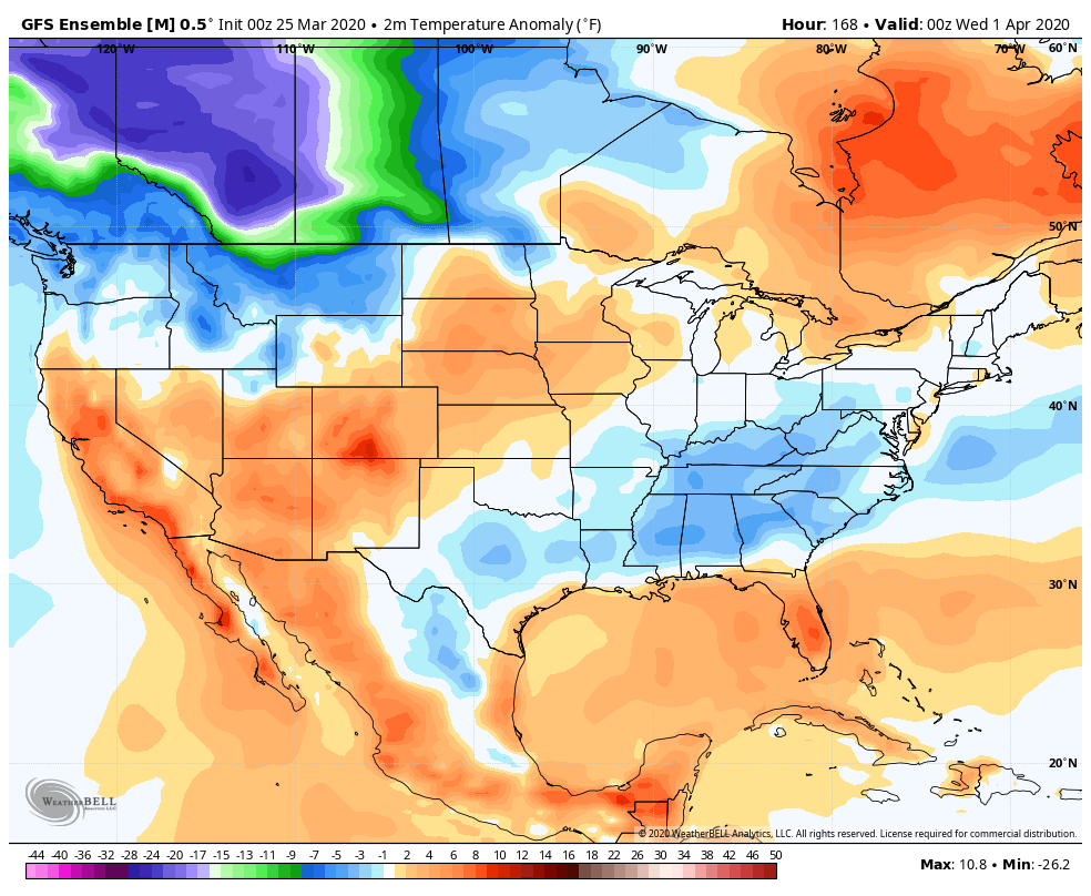
The setup for the middle of next week continues to look interesting. The trend toward a deepening trough has been there for a few days, but can we get a storm system to throw a little surprise for early April? The Euro has been showing that possibility for a while. Other models, like the Canadian are getting closer…
 The various ensembles are also trending toward a colder than normal look for early April…
 There are two things in weather that I absolutely despise… Warm temps in December and cold shots in April/May. Anybody with me on those?
I will have another later today. Make it a good one and take care.

It will not snow any more until Winter.
It wouldn’t surprise me to see some snow. It’s almost traditional to have a little flurry during the spring Keeneland meet.
I want to say thanks to Chris Bailey and all the regulars here at the weather blog. This is the one place that has remained the same in all this craziness going on and it’s provided some comfort for me on a daily basis.
Thanks everyone and stay safe.
I’m With you!
Thanks Chris, I will certainly enjoy the predicted Sunshine and warmer temperatures for the next few days. April snows are not that unusual for our area. Last year I had snow showers the Saturday before Easter Sunday. Take care everyone and make it a great day.
Mother Nature does not know Keeneland is not running this Spring so she is sure to throw some nasty weather our way early April as usual.
I’m going to need sunshine, warm, and dry during this time. Come on Chris seriously. Thanks for all you do!
I sure was hoping April would be warm…