Good evening, gang. Snow showers and flurries continue to fly across the region this evening. These will continue to put down hit and run light accumulations. This is the beginning of a very wintry pattern that should really get cranking over the next few weeks.
That doesn’t mean we have a walk in the park in the short term… clippers will make sure of that. We have two systems on the way for later this week into the weekend. Check out the upper level support for these two…
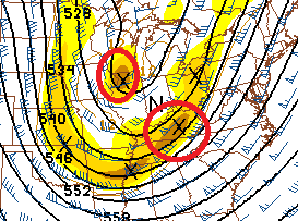
That’s the one digging in Thursday night into Friday. The lead energy is followed up by another one swinging in behind it from the northwest.
The next one for Saturday evening is looking stout…
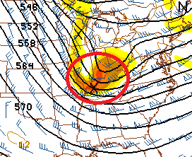
Those types of lobes of energy create a lot of light and that creates rounds of light snow and snow showers. Accumulations are a good bet from Thursday night through Saturday night. Some areas will likely pick up on a couple of inches before all is said and done.
The longer range continues to take on the look of a big time wintry period. Take a look at how these deep troughs keep digging in every couple of days…
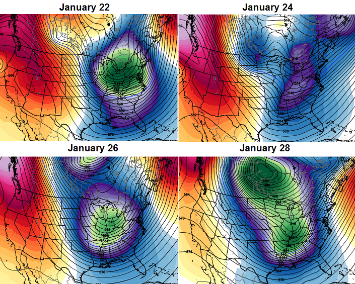 Setups like that usually lead to some extreme events across the country. The last week of the month into early February appears to be the prime time for the worst of winter around here.
Take care.

Looks like the next three weeks are our best potential for sustained cold and snow. Could always get a February or March surprise though. The largest snow I’ve had here in the past five winters was on March 4-5.
We of course are also closing in on the point where our average temperatures bottom out during the winter (roughly the 4th week in January) before rising again.
As mentioned before, I’ll never forget as a kid experiencing the March 13 1993 Blizzard in Morristown TN. By far the most extreme winter event I’ve ever exerienced.
PS: Some light snow now falling in Nashville, but with patches of clear sky also.
Hope we get something because we are running far behind in snow in SE KY
Agreed andy. We got off to a good start in nov, but rest of winter been cold winter rain, except for the small snow before 0 weather came in. We are running far behind, but still better then last winter so far. Would like see one decent snow for our area before spring gets here mid march. I sorta dread spring weather, if ky is still battle ground for warm and cold air.
1.5 inches total i wouldnt call that a good start
We have a light dusting, roads look ok for now.
Dropped to 16 briefly in Lawrenceburg and has now risen to 17. Clear skies and light winds make the temp drop like a rock. The temp is rising due to some cloud cover coming in.