Good Wednesday, everyone. Spring weather has taken over across the bluegrass state and that has many of us pumped up. With the good comes the bad and that bad is usually in the form of strong and severe thunderstorms. The threat for some big boomers will be on the increase late today through Thursday and Friday.
This threat has been on my radar for more than a week and it’s still showing up strongly. Here’s a breakdown…
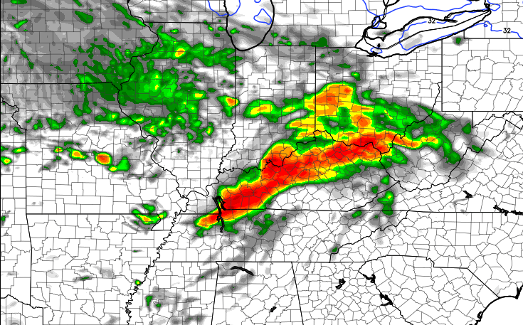
– Scattered showers and thunderstorms will zip across the state today with temps in the 70s for highs. Humidity levels will rise later this afternoon into this evening. It’s on the nose of this increase in humidity that we are likely to find clusters of thunderstorms. Check out the Hi-Res NAM for later this evening…
– Some of these storms may contain hail and high winds. That is certainly something we will need to be on guard for.
– Another round of thunderstorms will race across the region Thursday afternoon and evening. Those could also be strong or severe with damaging winds and hail.
– A powerhouse of a storm will then head toward the Great Lakes Thursday night into early Friday. That will drag a strong cold front across Kentucky…
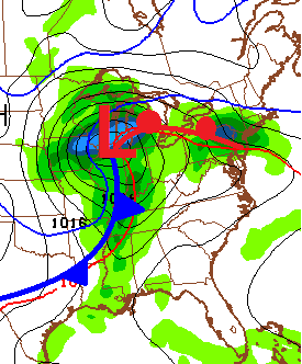 – A line of severe thunderstorms is likely along and ahead of this front. Damaging winds, large hail and isolated tornadoes will be possible. The Storm Prediction Center has most of the state in the slight to moderate risk for severe weather…

– Much colder temps filter in behind that for the weekend. Frosty cold mornings are likely.
– Another storm system rolls our way during the first half of next week. The week will be colder than normal temps and it could get pretty darn cold for a day or two by the end of the week.
Let’s get back to the stormy pattern we have for the next few days. Here’s a look at today’s severe weather tracking tools…

Today’s Risk Area

Current Watches

Possible Watch Areas 
I will have updates as needed. Take care.

Thanks Chris. Have been laid up with a nasty stomach bug for the last couple of days. Didn’t even poke my head out the door yesterday. A wasted beautiful day. Guess we are finally turning the corner toward spring, at least I hope so. Have a great Wednesday everyone and thanks again Chris for all you do.
Did anyone see the mythical creatures in Pikeville yesterday? I have photos of a mermaid and what looks to be a fleet of UFOs on my blog haha
Ugh. Humidity already? Counting down the days to fall.
Stop the presses! April is over 15 degrees above normal in Lexington for month to date 🙂
Lots of clouds and a storm cluster just to the north of frankfort is holding temps back today, 70 degree weather might not happen today in frankfort 🙁
Wow, temps are REALLY busting. It’s almost 1pm and Louisville is standing at 53°, the forecast from the NWS is 73°!!! A 20° bust as of now! Lexington is at 58° so not much better, let alone Frankfort which is at 49°. The only way I see is hitting at least 70° is if the clouds move out right now and sun for the rest of the day, which is not happening.
Currently 79 (air temperature) here in Nashville. 74 in Bowling Green and also Paducah.
In addition, Nashville’s dewpoint temp is 57, much higher than yesterday when much of our area had dry 40s and even 30s. An indication of the fuel for the upcoming severe wx.
84 here that’s about 10 degrees above forecast.
OK, maybe we will hit 70, Standing at 68° right now. I shouldn’t have underestimated the power of the sun angle this time of year. Regardless, still below what was forecasted.
SPC has now upped the risk a little regarding a few isolated tornadoes in far western parts of Kentucky and Tennessee for later this evening.
However, strong destructive straight-line winds and large hail remain the risks with the higher chances. Heavy rains with some occasional flooding issues could also come into play, especially areas close to the Ohio and Mississippi Rivers.
Thanks CB for all you do, especially keeping an eye out for severe wx!
Yeah there is a huge temp gradient happening, 80 degrees on the ky/tenn border to 52 degrees in northern ky temp should slowly to steadily rise regionwide as the warm front is on the move. For those areas that dodge any rains your high temp for the day might not get recorded till 11:59 tonight.
No rains here not looking forward to mid 80s tonight 😉
Actually, since no rains, according to prelude, you should be hitting 90 or better tonight.
Israel and Andy within reason you clowns im talking temps should hit around the upper 60’s to near 70. Not stay in the 50’s. There’s at least one or two clowns in every crowd.
I apologize very much Prelude, I just had to do that. I shouldn’t have…
72 in Danville right now. Simply perfect!
Well no snow in the forecast
Well in the 80s I’m knott co today for 2nd day in a row
Some nice lightning displays going on late this evening, according to lightning detection equipment.
The SPC had a Mesoscale Discussion during the late afternoon about a 60% possibility of a watch (either a Severe Thunderstorm Watch or a lower-tier Tornado Watch) being issued for western parts of KY and TN. Thankfully no watch was issued; as only a few isolated severe thunderstorm warnings have ended up been issued this evening.
Of course the overall severe threat really goes up tomorrow. SPC will update their outlook about two hours from now. Hopefully the tornado risk will remain relatively isolated, although the hail and damaging wind threats could be high.