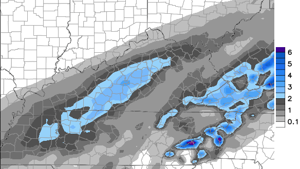
Good evening, gang. I wanted to drop by for a few thoughts on the winter weather rolling in Friday into early Saturday. Before I get to that, here’s the First Call For Snowfall…

We’re likely to see a corridor of moderate snow setting up from southwest to northeast later Friday evening into the wee hours of Saturday morning. Uncertainty exists as to where this will be, but the blue zone I have on the map is where that looks to be at the moment.
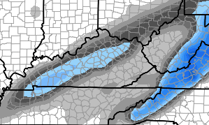
The late afternoon model runs suggest I am on to something with this band and some even take it a step further. Most of them are a little more beefed up with this band…
GFS
European Model
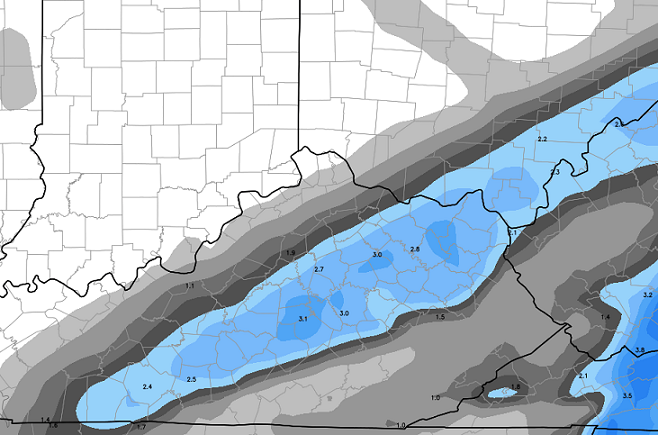
European Enesmbles
 I admit, the late day trends have me just a little concerned that I may be underplaying things.
All of this does start as rain from south to north on Friday, but temps will drop quickly as precipitation moves in. That means a change to wet snow during the evening and then we will have to watch and see where this band of moderate snow sets up.
Southeastern Ky folks… there appears to be a secondary burst of some snow aimed in your direction Saturday morning into the early afternoon. That’s a recent trend that is also looking better as we get closer.
While I have hit the models with their daily output, they did show this storm system from well over a week ago. They are doing the same thing late next week into the weekend…
GFS

EUROPEAN
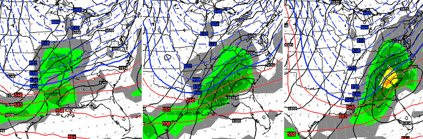 It’s just a week away… what could go wrong? 😉
Enjoy the rest of your evening and take care.

Same ole Same ole
A lot of soup for you!
SnowCream? With just a touch of vanilla.
Tired of left overs Israel 😉 My comment was pertaining to the models showing 7 day away snow and it still being only rain with flurries
Well look at the brightside, snow tires are no longer required in ky
I just wish i had known this 8 yrs ago when i got my truck LoL.
I’m Sorry but soup is the only option. Enjoy! 😀
Jealous of the middle of the state. LouMetro looks like a dud. Enjoy what you get.
thank you chris for all you do to keep us weather weenies happy……you can’t do any thing about what the weather does……you can only report as you see it happening.
Is that actual snowfall that will accumulate Im pretty sure with marginal temps there will be somewhat of a melting factor?
Is there still a system coming in Sunday night?
Long time no hear from. 🙂
Help me Rhonda, Help- Help me Rhonda! Ever heard that before?? 😉 🙂
BubbaG, many, many times, lol. One of my favorite songs.
Spring, please spring.
I could use some NW shift this time around… Lol
Cheer up folks. The days are getting longer and we all woke up this morning. Thankful for the blessings of the day and for a weather blog for those of us who love weather! Snow? Would love it, but if it misses us, ah well, maybe next time. Have a great evening all and thanks Chris for the update and for all you do!
If this blog had a “like” button, I would have hit it for your comment & attitude.
This!
A perfect perspective, Coffeady! 🙂
Come on blue zone…just a little further south!!!
Hey at least there is another storm to track seven days out. Hhhhhmmmm I think we have a new trend to add to our list of on going KY trends.
Okay….. This too! 🙂
Right on!
Somebody post the new NAM snow map! 🙂 I want to see this band that Chris speaks of!
Lol…great looking dry slot as the storm gives SEKy and part of WV the finger. This winter continues to be a complete failure and looks to continue for another week or so. The bright side after that is it looks like a very cold dry pattern should dominate as we go into Feb.
Since its gonna be mostly rain that’s fine by me
No soup for y…… Actually, I think you could use some soup! You and Bengalfan.
I’ll donate the spoon!
Feb = $$$
Im getting bout ready start thinking about pkanting maters and stuff. May even tackle broccoli again this season.
been wasted winter, cold and not much precipitation except for rain in december.
Im ready to try garden a little. Maters I know ill put out, everything else is questionable just yet.