Good Friday to one and all. Legendary. That’s the only word I keep coming up with to describe the past 3 weeks of winter weather here in the bluegrass state. Back to back historic snow producing winter storms with numerous record cold temps have helped to make this period the new standard bearer for future winters.
Over the last 17 days, much of Kentucky picked up 2 to 3 feet of snow. Lexington is now within the top 5 snowiest winters on record with 40″ since November. We can still add to that before true spring arrives.
The last storm was historic with the amount of snow that fell. It becomes pure legend when you consider the amount of snow that feel in less than a 24 hour span…
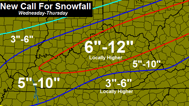
Just absolutely absurd amounts of snow! There’s a lot of water in that snow and we will have to watch to see how quickly it melts. With several areas still dealing with high water issues, we need a slow melt in the coming days. That currently looks to be the case as we don’t have a big time warm up in the cards until the middle and later parts of next week.
In the short term, it’s all about the potential to start the day with record cold temps. Readings will likely be below zero in some areas and a few cities may see some of the coldest temps they’ve ever head in the month of March. Afternoon highs will warm into the mid and upper 20s over the deep snow pack with low 30s for those who don’t have a ton of snow.

Temps over the weekend will slowly moderate through the 30s and may hit 40. Temps will rebound through the 40s early next week with a light rain maker zipping in. Later in the week temps make a run at the 60s, but watch for a cutoff area of low pressure trying to steal the show.
It’s an up and down temp pattern I see taking shape over the next few weeks. It’s also one that has some more ugly written all over it with the potential for some decent rain makers.
Have wee seen the last of the falling snow? Very doubtful.
I will have another update later today. Take care.

More snow?? Might as well go for the all time snowiest winter……we are on so close!!!! Me…..I LOVE all of this snow.
Thanks Chris for all of your hard work and dedication to the blog and WKYT! People always ask me who I listen to about the weather…..I tell them Chris Bailey is the only “weather dude” to pay attention to. Hope after this weekend you get some much deserved R & R!
Haha! Me too, Lisa, Chris Bailey is one AWESOME weather dude! I started following him back in 2011 and his blog is, without doubt, THE best and most accurate out there. He has saved our bacon regarding severe weather outbreaks on more than one occasion, such as in the run-up to Superstorm Sandy. I had told everyone I knew, including our church congregation, to get ready for 3 feet of snow a week in advance, and most of them laughed at me. Well, our snowshoes arrived the day before the snow started, and we were ready for the 7 day power outage. By the time the snow finished falling we had 38 inches on the ground 🙂
Did anyone else almost had a heart attack when CB said “It’s also one that has some more ugly written all over it with the potential for some decent…” I thought he was gonna say snow! I said back in February that I wanted one more big snow and I was done and many others did too. 95% of Kentucky is now satisfied with this dome busting winter of ’14-’15. One sad part is southeast KY has missed out on the biggest action, but hey, 5″+ is still decent compared to how it has been for the past 15+ years. We finally see light at the end of this white tunnel, and by next month, we will be seeing 70s! Oh man I have I never be so excited to hear about warmer weather in my life!!!
His last statement about the weather makes it sound as if we could get more.
“Have wee seen the last of the falling snow? Very doubtful.”
So we make get another round before we get Spring.
What is most amazing is to go the past 17 years with 1 to 3 or 2 to 4 inch snows, wondering why big snows don’t happen here anymore, to T*H*I*S*. I’m not sure absurd or legendary are strong enough words.
No doubt! I keep telling my kids to look around and take it in because it might be another 15 20 years before they see this again.
Or it may be in a couple weeks. Or even next winter.
New trend point now. Let’s see next winter if we get a few 8″ or greater events, or the year after. Not expecting big ones like these, but maybe the trend cycle has come around.
Balmy 3 degrees in Carrie of knott this morning
Fayette Mesonet does show tying the record low for this date but that’s it. (+7). Interesting versus all of the others in the region.
Again, unless Berea is unique in its snow, 80% of what fell was powder and not wet snow. If what fell was wet snow, there would have been power outages all over the place.
Being from southeast KY, and now living in Eastern Tennessee, I think Tennessee should annex southeast KY. Then, instead of being the ones with the least amount of snow, you would occasionally be the ones with the greatest. 😉
We pretty much missed out on the “big” stuff with every system. What is even more odd is 30 miles south east of us picked up some nice totals from systems that missed central KY. 30 miles north of us got it. We couldn’t catch a break and the dome survived in Knox.
Your snows coming in April Bob…lol I remember 1987 April ( easter snowstorm ) over 14 ” there in Knox co… Or come on down and join the warm side gonna be in mid 70s here in east tn. Next week….
On an unpopular note anybody down 11s way is blocked from Corbin and Barbourville. This is easily the 2nd biggest tide in 18 yrs down this way.
How much did you end up with Andy. His map is way wrong for us. We might have maxed out at 2 inches. I agree with Bob annex with TN we get left out on most forecast and usually have the warmest temps in the state.
I had 3 inches mixed frozen precip and 3.7 of rain before then. I would be on the low end of wherever he pulled his numbers from Flood is the issue here. I have only seen the water this high 1 other time in 20 yrs.
Sorry to hear that Andy, but such things as destructive flooding are to be kept on the downlow here unless of course that flooding were to be in downtown Lexington or anywhere in Fayette…
I figured it was bad through there. I used to drive from Corbin to Barbourville on a regular basis. Very low land surrounded by hills, prone to flooding.
I fear the flooding is going to get very bad in the next few days.
From Twitter…
Knox County: KY 6 m.p. 6-7 Blocked Due to High Water River Reading is 35.25 at 8:30 this morning.
http://twitter.com/KYTCDistrict11
It should start going down. I went to look around this morning and will be going out to check on it this late afternoon.
We drove around and looked at it yesterday evening. It is higher than I have seen it in a long time and I have lived here all my life. I am praying next week’s forecast changes 6 days of rain after Tuesday according to weather channel. We do not need any more precip of any kind.
Exactly
This has just been an incredible 3 weeks or so.I think we have had some of every type of precipitation.
Was this past storm NOT your typical low pressure storm? Is there a name for what type of storm we had? I know I hear of apps runner, B Miller, things like that……Does what we just had have a name?
Looked to me like the most typical of March systems, that open the moisture pipe of the Gulf and always give us our Spring rains, but this year happened to catch a break and got a cold front slamming into it. I guess the odd part of the mix was the cold front slamming through then stopping, allowing the “backside flurries” to …. pile up a bit.
This was the sort of setup that normally would have been a fast mover, but a high pressure in the south blocked the surface low, allowing the moisture to train over us, the low was located just far enough to the south that it allowed enough cold air to infiltrate the heavy moisture allowing it to fall as snow, normally the arctic air would have shoved the low to the south, but it couldn’t do it because the high pressure was occupying that area. At least that is what the experts are saying.
Yes – I had not looked at why the front stalled out, but that makes sense.
Chris you’re hands down my favorite meteorologist. I’m only 20 years old, but I remember growing up watching you on WSAZ “back in the day” and you were the person that made me really fall in Love with weather. I go to school at WVU in morgantown (originally from pike/MIngo county) but still follow your weather blog on a near day to day basis. It’s amazing to see where certain people are from on this blog. I’ve heard anywhere from northern wv to western tennesee. Keep up the good work Chris!
Good morning from central Florida. We had temperatures in the upper 80’s, flirting with record highs. Today, not getting out of the 60’s.
I have been keeping up with everyone’s comments about this ‘snowminator’. Looks as if many snowfall records were terminated.
Coming into February, how many of us had already given up on winter?
You now know that future February and March winters will have to answer to the winter of 2014/15 thereby proving winter’s not over until it’s over.
“I’ll be back” by the middle of next week. Hasta la Vista.
Winter definitely has gone out like a lion.
Yea Bubba…….And I’ve said this with the last storm and I will say it with this storm, because I think it needs repeating. Your 33 plenty of moisture rule along with your south of the KY river rule is dead. Do you hear me? DEAD!
Mother nature badger doesn’t give a shoot.
I don’t know if the rule is dead or not – climate rules are long-term, and when you smash records, you have to acknowledge that you’ve seen an anomaly. Two 10+ inch snows for Central KY spaced less than a month apart near the end of the season when the sun angle works against you is extraordinary, and we could go decades without seeing it again.
If something similar happens next year, and then the year after that, then you can start looking at the possibility of a climate trend.
Climate trends are loooong. That is why I always find it funny for the climate change debates (as an example). Snow a few years in a row or not, a trend as far as actual climate direction is decades (at a minimum). Sun activity and volcanoes exponentially trump anything we can cause in the shorter term, but folks take the arrogant approach that we can control the climate. Nope.
That is correct Jamie.
A good winter for sure. In my part of Richmond we had a 12” followed by an 8” snow fall with perhaps 2” total falling earlier. I am still amazed that 25 miles north typically has double the amount. (Lexington has had 40”?!?) Now, I am getting greedy – I would like to experience another 2 foot snowfall. I remember a storm as a boy in Nebraska where it was close to three feet and would love to experience it again!
Still amazed even Richmond had big differences. That is just five-ish miles form the big cuts.
Nebraska isn’t doing too well in terms of snow this year, at least yet….I find that very surprising.
Just curious as to when in June we might finally get out of school. Bad feeling it will be late like last year… 🙁
On a positive, I guess, June 30th is as far as we can go.
This was so exciting for a snow lover like me who wasn’t alive to experience the winters of the late 70s. Will we ever see a storm like this again here in central KY? Who knows. I’m just grateful that I got to experience it. Just over 16 inches in my backyard here in Anderson County.
Really looking forward to warmer temps on the way. It’s time for a switch in the weather. Even 40s at this point will be a noticeable change 🙂
One last shoutout to the MEGA SNOWSTORM of 2015!!!
Well old lady got our drive all shoveled. She hopin that you ain’t right Chris bailey and she done for the winter. She said she’d fry ya up some bacon fresh from the pig if ya make all this snow business stop. Can’t be getting out when its like this.hope all this is over.
Looking outside my window is just painful with that bright sun hitting the sea of whiteness.
Don’t becomes snow blind. And yes, “snow blindness” is a real thing. Put some sungla-sses on if you can, which they should be called “snowgla-sses”
Andy, we are cut off by flooding on 11 S in Knox. It’s the first time that’s happened in at least 15 years. Although they raised the road 13 years ago to help with flooding, water is across in between the 2 places it was raised. Last night my husband, who works in Corbin, tried to come home through Barbourville instead of taking the back roads like he usually does. He didn’t know 11 S was blocked by water. Upon realizing the road was blocked, he went back to Corbin and had to travel icy back roads to get home. I guess you could say he took the long way home!
the way from Corbin is blocked now. I was sent pictures taken at 8 and the water was over at Thompson park near the flood wall and in the curve right before GR
This weather has been amazing. My oldest, 16, has only seen decent snow once. That year everything was froze over and the snow was pretty deep here. Told them to enjoy it since these are rare events in Kentucky. I think they are ready to move to spring though.
Thank you Chris. Y’all did a super job per usual.
Hope you get some rest before the next round of crazy happens.
I’m truly glad my kids got to see some old school snow. It’s been beautiful. We ended up at 14″ near downtown Lexington.
Amazing how warm the sun feels even though temp wise we are below freezing, time goes up Sunday, Chris has 60’s in the forecast, I think I hear spring
18 inches in east frankfort, wow, the doom has officially been put rest.
Now sprin bring it on 🙂