Good Thursday, folks. Rounds of showers and storms have been common across the commonwealth of Kentucky over the past few days. This is the beginning of the wetter pattern I’ve been yapping about, and it looks to settle in for the long haul.
Scattered storms will flare up again today and some could produce localized high winds and hail. The storms will contain heavy rain and a lot of lightning. Outside of the storms… temps will hit the middle 80s, at least.
The thunderstorm action should increase later Friday into the upcoming weekend as a cold front approaches from the northwest. This front slams the brakes on across our region and that allows for more widespread action to develop. You can see that well on the GFS…
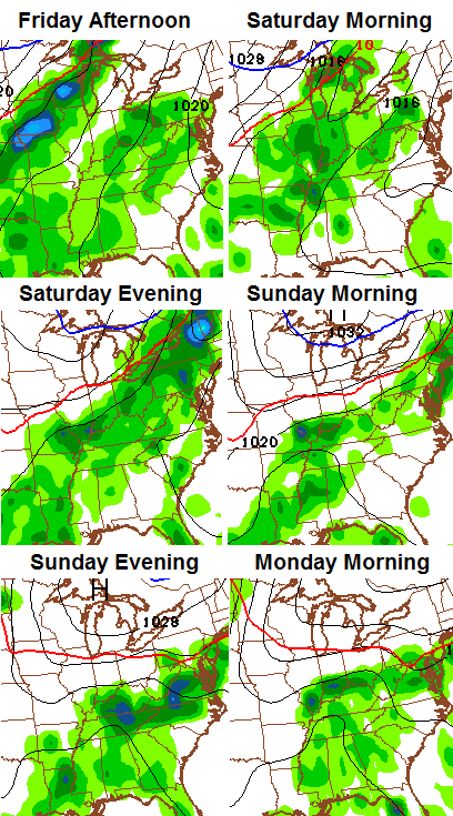
Some strong storms will be possible during this time. We will also have to keep a close eye on the high water potential. The atmosphere will be loaded with moisture, and with a front in the area, that could cause some very heavy rain producing storms.
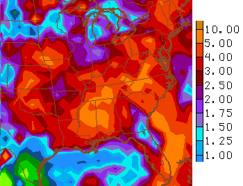
The models continue to spit out high totals over the next week..
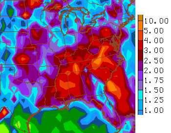
That’s a trend that continues to show up through week 2…
 I leave you with your daily dose of storm tracking tools…


Today’s risk area

Current watches

Possible watch areas 


Enjoy the day and take care.

Thanks Chris. Hope we can get a chance took the yard in between showers. And that we don’t get too much of a good thing! Have a great Friday Eve everyone. Thanks again Chris, for all you do.