Good Friday, everyone. If you’re a fan of warm and humid days with rounds of showers and storms… cheer on, that’s exactly what we have out there for the foreseeable future. As a matter of fact, rain and storm chances look to ramp up as we head into the weekend.
Today’s forecast is pretty much the same one we’ve had over the past few days. Scattered showers and storms will fire up and some of those could put down some very heavy rains. Isolated strong storms will also be possible.
A cold front works into the region over the weekend and then slows down. Showers and storms become much more widespread and we could be looking at some strong storms going up. The biggest threat may come from the heavy rains…

Tropical moisture in place with a stalled out front could lead to some local high water issues. Just something to keep in mind as we make those outdoor plans.
That pattern hangs tough through much of next week. Many of the models are suggesting a potential tropical system trying to organize near Florida…

Whether this develops or not, the models try to tap some of that juice and work it into our part of the world. You can see that on the GFS rainfall forecast. Here’s the outlook for the next week…
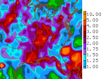
Now add on the following week…
 After a brief break over the past few weeks, stormy times are back in the bluegrass.


Today’s risk area

Current watches

Possible watch areas 


Have a great day and take care.

Well, Wichita Falls drought is officially OVER for the first time since 2010. Crazy! They have had almost 17 inches of rain in May…..Has this area ever had long-term drought like that? I doubt it because it isn’t nearly as arid here as it is in that part of the country. I know we have had our share of drought, but I don’t think we have ever had that intense of a drought for that length of time in the eastern part of the country, have we?
I don’t think we ever have. now if we can just shift some of that ran to the west. CA could use some rain love now.
I have received .7 tenths of inch of rain near Harlan this week which is an improvement over the past 6 weeks, but it is really dry in this part of the state. Without a lot more rain soon, we will be in a drought near the Virginia/Tennessee border counties!
Drove through some nice rains that hit the northern part of the county here as well. Still not anything at my place for a long while. Heard thunder a few days but nothing. Rained not far from here though a few times.