Good Sunday, everyone. The overall weather pattern for the week ahead is a rather busy one with three cold fronts on the way to the bluegrass state. These fronts won’t have a lot of moisture with them, but will bring chilly shots our way. That could all lead to a frost threat by next weekend.
The first front arrives late Monday into Monday night. A band of showers and isolated thunderstorms will sweep eastward across our region during this time. Temps for Tuesday will reach the middle 60s in most areas on a gusty northwesterly wind.
A weaker front drops in on Wednesday with a reinforcing shot of chill. Maybe some upper 30s by Thursday morning?
That depends on the timing of the next cold front that swings in Thursday night and Friday. That’s with a system that could produce the first flakes of the season in the Great Lakes and northeast…
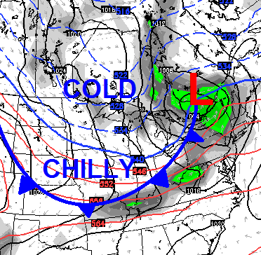
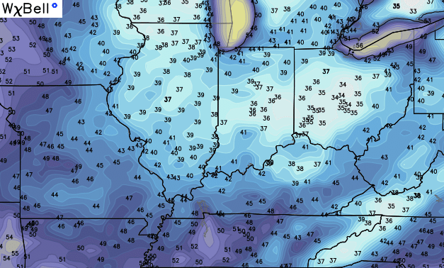
The air behind that front will be the coldest of the young fall season and could very well deliver our first widespread frost. Some of the model forecast lows are way down there. Here’s the Canadian…
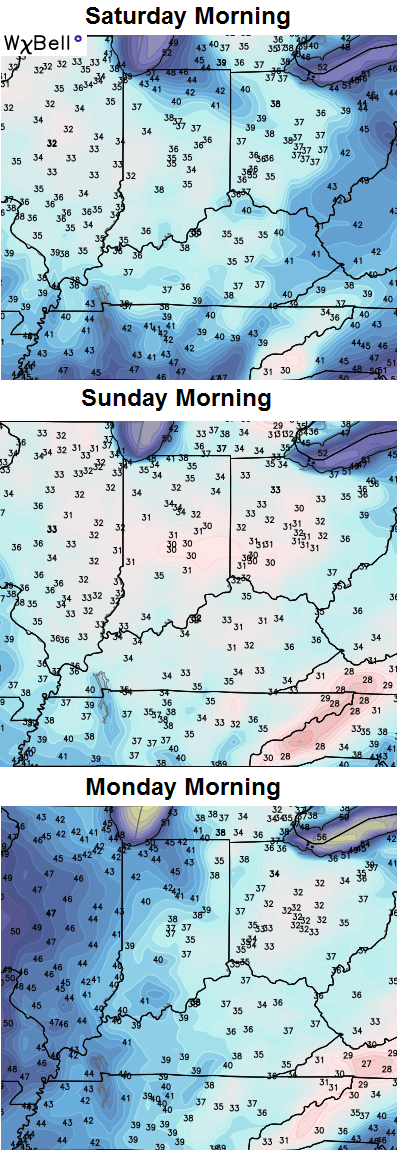
The GFS Ensembles also has a frosty look by Saturday morning…
For an average of 21 different model runs… that’s a pretty cold look.
As you know, we have a strong El Nino cranking out in the Pacific. If you’re a regular reader, you also know I’ve been saying since early in the summer that this El Nino has no equal in terms of overall strength, timing and placement of the warmest waters.
I also said you would be hearing a lot of weather folks wrongly saying “this is just like 1997”. You be the judge…
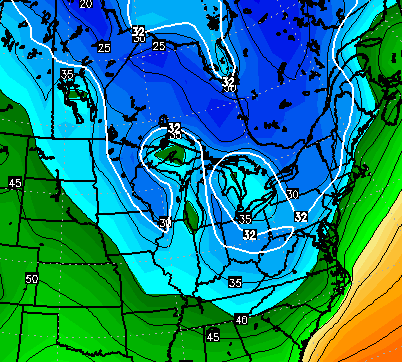
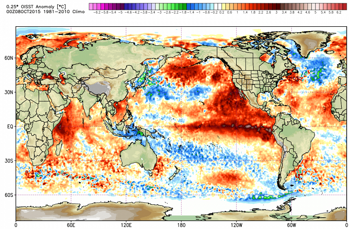
Current ocean temperature anomalies…
The same time in 1997…
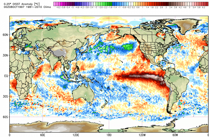
The first thing that stands out is how super warm the water is across the entire planet compared to normal and certainly compared to 1997. The Pacific waters off the west coast of Mexico north to Alaska are crazy warm. That wasn’t even close to being the case in 1997.
The actual El Nino temp anomalies from 1997 are clearly greater and farther to the east of the current greatest anomalies. Better yet… the current warm anomalies are forecast to shift farther west and creating even greater distance with 1997 in terms of placement.
Finally, check out the warm Atlantic water off the east coast. That was not there in 1997 as the water was actually colder than normal.
Other than the pure numbers of this current El Nino, my eyes, it has very little in common with 1997. As a matter of fact, that year is not in my top 5 analogs for the rest of fall and into winter.
Have a great Sunday and take care.

Thanks Chris – but maybe a repeat of the 97 98 winter wouldn’t be so bad – at least here in CKY. We had the m-a-s-s-i-v-e snowstorm Feb 98 that we have talked about over and over and over – even though other than that, that winter was pretty boring if I remember correctly.
Hey Chris, so what are your top five analog years, if you’ve already posted them, I missed it. Yea, clearly this years set up is way different then ’97. Still curious how all the warm water will play things out. Should be fun to watch it unfold.
I love the current contradiction on the Weather Channel. A few days ago, they posted, once again I might add, the same video depicting the overall drier and milder than average winter prediction for most of the Ohio Valley/App Region. Then, I saw another video that came out yesterday released again showing the cooler than average temps for the Ohio River south to the Gulf Coast and Atlantic Seaboard for December through February. What a load of crap. How can you post 2 different videos contradicting one another. Then AccuWeather is on this dry, mild kick as well except they have the milder and dry weather a little north and west of some of the Ohio Valley Region as SE KY is shown on the edge of the cooler and wet conditions, once again based on “typical El Ninos.” Yet, I have not seen a dry El Nino event yet in my 32 years of life…
Go with CB’s forecast and certainly be prepared for some “possible” big storm events and overall cold weather this winter!
Don’t think anyone can truly say what will happen with this coming winter with such a uncharted strong El Nino.
Buckle up and enjoy the ride.Isn’t it time for Rolo-and Bubba g?
My goodness, what a beautiful day. You just can’t beat fall.
Hoping for big snow in Northern Kentucky this year!
Lets see…+PNA..-EPO..Possible -Ao with -NAO sneaking in..Along with a strong El Nino that looks basin wide with forcing at the dateline..STJ very very active..Aleutian low retrograding SW..I predict Epic winter for Ky like Boston had last winter..
Sounds possible and good to me:)
If we had a winter on the same scale that Boston had last year’s that would be crazy! We would be buried in our houses for weeks!
It’s a great day to be a Bengals fan.