Good Monday, everyone. A parade of cold fronts will cross the bluegrass state over the next few weeks. This sets the stage for frosty conditions for much of our region. As a matter of fact, the growing season could very well come to an end this weekend.
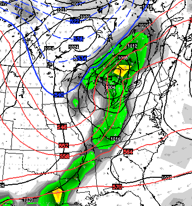
The first front of the week arrives tonight with a broken band of gusty showers and a rumble of thunder. Winds will be very gusty ahead of this front with highs today in the 70s.
Tuesday will find temps in the low and mid 60s with a gusty northwesterly wind settling in. Another, rain free, front arrives Wednesday and knocks temps down a little more. Upper 30s and patchy frost are possible by Thursday morning…
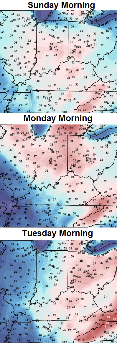
The real deal shot of cold arrives on Friday in the form of… wait for it, wait for it… another cold front. This front arrives during the time I’ve been yapping about for a while now, and could end the growing season. This is a heck of a cold blast…
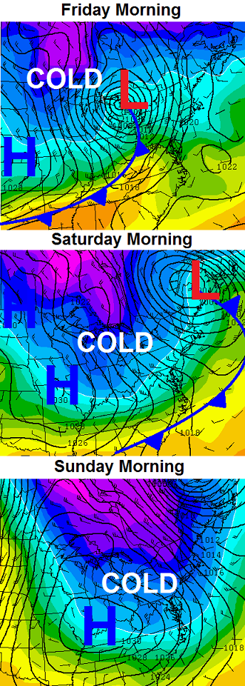
Not only is widespread frost a possibility, but a freeze can’t be ruled out. Some of the model forecast lows are into the 20s…
Folks, that’s some very cold stuff showing up across our region and into much the eastern part of the country. This has been well telegraphed to anyone looking at the overall pattern across the Northern Hemisphere. Pattern recognition is a key part in forecasting. It trumps models, but is becoming a lost art in today’s weather world.
Another cold front is likely to sweep in a few days after that cold shot moves out…
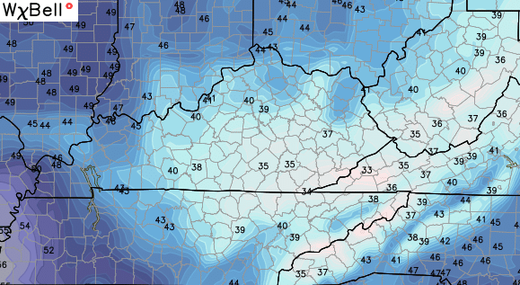
I leave you with regional radar to track some late day, broken showers and storms…

Make it a great Monday and take care.

Based on last year’s performance, it will be fun to watch the Madison County mesonet site this week. (Last year it was on the extremes end of cold most of the time. It was as much sat 8 degrees colder than what my thermometer showed, a mere 5 miles or so away.)
CB, that is why the national mets and canned sites like Accuweather and Weather Channel are usually wrong in outlooks. They go on autopilot using models, regardless of how inaccurate they could be. That is the key thing about who they are- no accountability for being wrong, so no desire to make the efforts like mets such as yourself.
Good link if you follow the snow index in North American,Eurasia in regards to the – AO..Didn’t work out last year,anyways look’s to maybe start to take off..
http://www.aer.com/science-research/climate-weather/arctic-oscillation
Actually, I saw this last night. An update is coming out on Wednesday for the next two weeks. Will be interesting to see if the AO will stay in negative to neutral territory. It’s been said if the AO is negative in Fall, then the winter will also have AO readings negative. It will be quite the battle between the surging subtropical jet to the south and a Polar Jet that will want to cross the U.S./Canadian border.
Fine line between a lot of cold rain or heavy snow. Must admit I have had my big snow fill 🙂 I remembered all the good things, but not the bad until dealing with it in March. If my kids were younger, perhaps my perspective would be different.
Don’t be a party pooper! Bring on the the ol’ school thumpers! To my part of Richmond, anyway.
Old school thunder shower in the Metro. Slow, rolling thunder and gentle rain. I can’t remember the last time I heard thunder this past summer. Ready for a nap.
Love…love….love your posts!!
Hey CB, What is going on with the Radar, it is not live from KYT, obviously coming from Lville, did you guys sustain a lightning strike or what, hasn’t been operating for some time that I have noticed, Maybe you can address in a future post. Thanks