Good afternoon, folks. Our Flood Watch has been expanded to include more counties in southern and southeastern Kentucky. This is part of the state that will get in on torrential rains later today into tonight. Once this goes by, we are likely to get in on accumulating snow Thursday night and Friday.
Here’s a look at our Flood Watch…

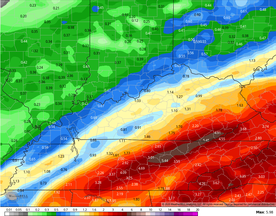
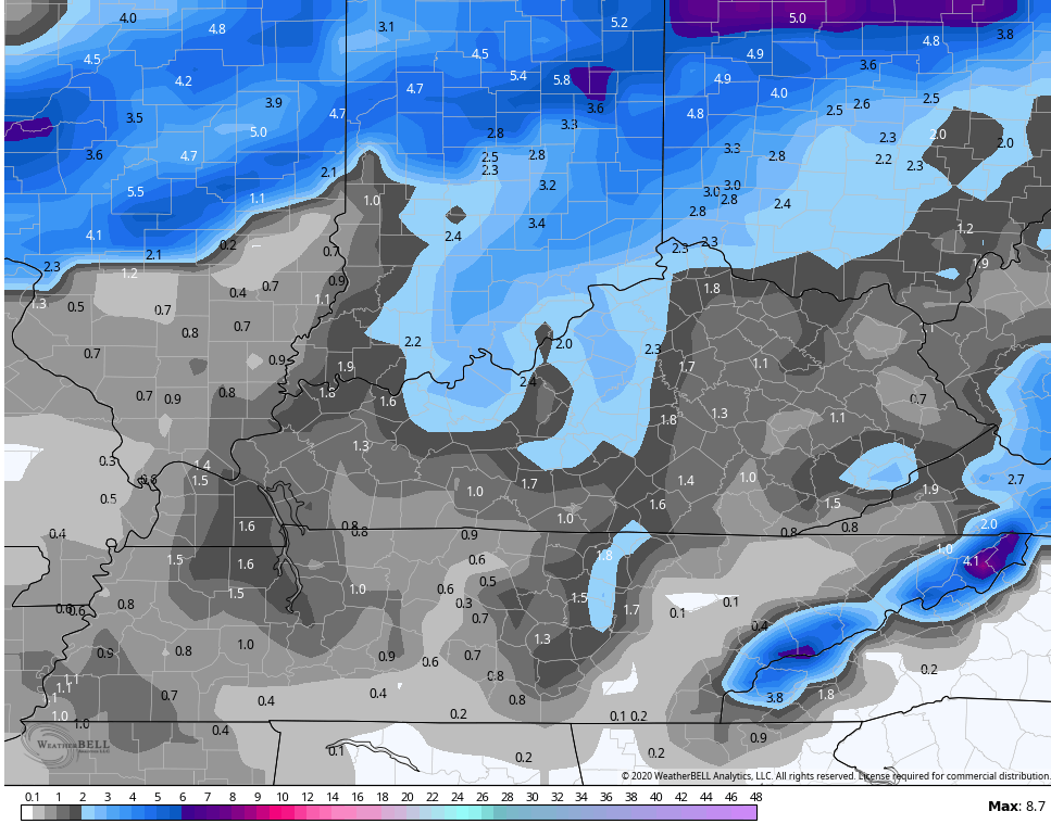
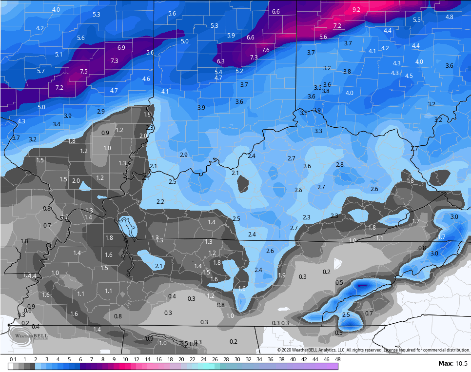
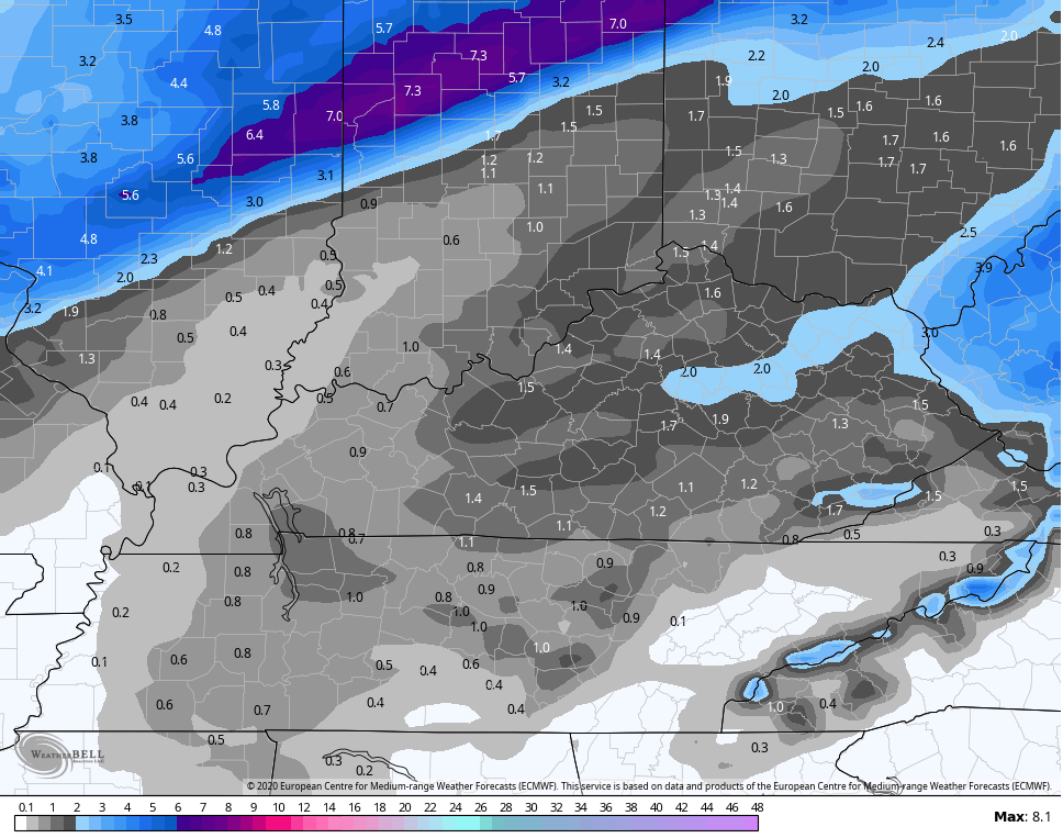
Given how much rain has already fallen, the forecast numbers through tomorrow morning are very concerning…
NAM
 GFS
GFS
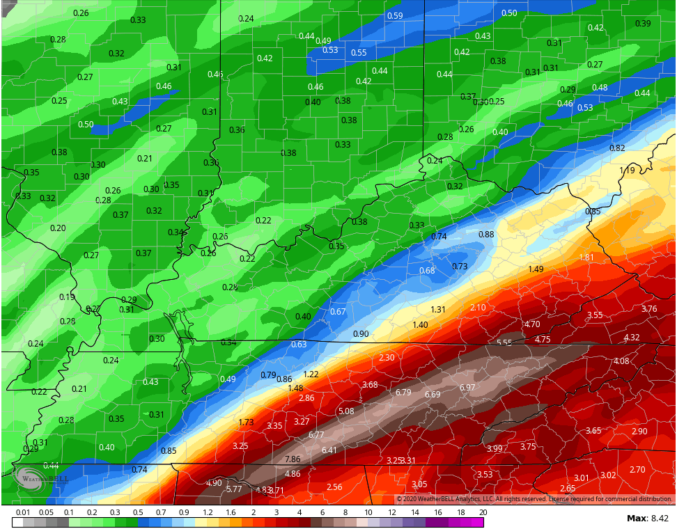 Flash flooding and general flooding issues are likely with those numbers. Please keep a very close eye on water levels and be prepared to move to higher ground.
Here are your tracking tools for the afternoon…


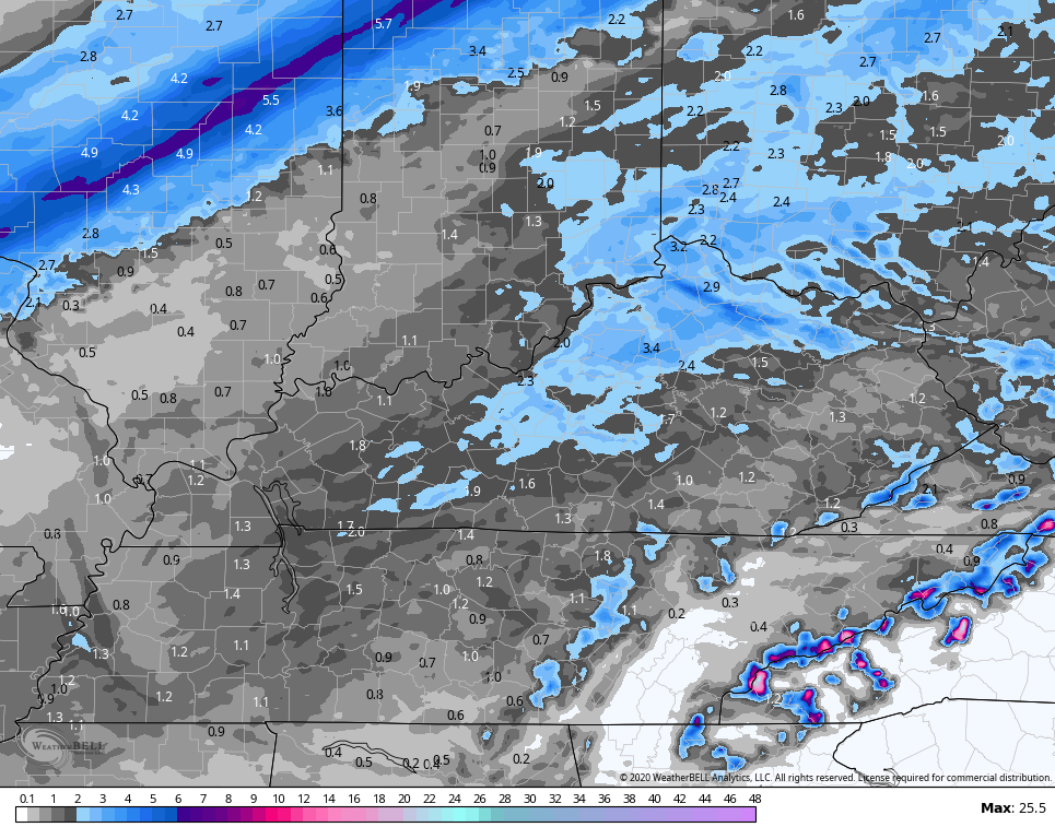
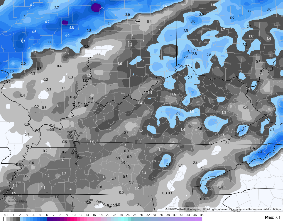
The light snow Thursday night and Friday continues to look more widespread with some areas potentially picking up on a few inches of snow.
Hi Res NAM
 NAM
NAM
 GFS
GFS
 Canadian
 Early morning EURO
The system coming in behind this for Saturday will drop some more light snow on the region.
Next week turns stormy with heavy rains returning. Yay! 🙁
I will have the latest on WKYT starting at 4pm then again on KWC this evening. Make it a good one and take care.

Thanks Chris! Oh please let it snow! My kids want some so badly (and, ok, so do I)! Thanks for all you do!
Meanwhile, Coffeelady is HOME and if you haven’t heard from her yet, you will be soon! thanks again everyone for your thoughts and prayers!
Hi! She’s been here a couple of times in the past few weeks! So happy she is recovering, and many heartfelt prayers and wishes continue to go out to her! She’s absolutely THE NICEST on this blog, and we sure have missed her! It just hasn’t been the same without her and her positive comments I’ve had the pleasure of reading the past 10 or so years! Here is hoping she will continue to get better and better and bless us all with her presence on the blog! 🙂 <3
LOL..You calling us other people ‘mean’. I get it 🙂
I love the Coffeelady as she doesn’t complain like the rest of us and certainly is respectful, kind and 100% sweet!
Nooo…Not at all! She has always been here since I’ve been here, and she’s always just the sweetest and nicest commentor here! Never a bad word to anyone, just as you said, too! 🙂 A very lovely lady that we can all learn from?! <3
Glad she’s on the road to recovery!
https://www.pivotalweather.com/model.php?rh=2020020512&fh=384&dpdt=&mc=&r=us_ov&p=qpf_acc&m=gfs
May have to get a bigger rain gauge in SE Ky if the GFS is right..Goes through February 21st..No doubt that will move north some..Lordy Lordy..
It is incredible really. This likely ends up my third consecutive February with 12 + inches of rain! That number would be a good amount of snow but RAIN! OH MY.
Old school Clipper coming to visit our state this Saturday.
I don’t think I have seen this type of system for at least three years.
Looks like the heaviest of the snow will miss the Chicago area to the south and southwest tonight and Thursday morning, as that’s where the Winter Weather Advisories are. There are even Winter Storm Warnings near the St. Louis area. Still, the NWS is predicting 2 to 4 inches for most of the Chicago area by Thursday afternoon, even though there is no WWA yet for the area. We’ll see if they find it necessary to issue one later on. The snow is on track to get here by 4 PM local time.
Meantime, looking at the radar, there’s really an impressive area of rain moving into Southern and SE Kentucky from Tennessee. Looks like your area is in the bullseye for the heaviest rain, Terry!
It is heavy now. Really, only half inch today but very heavy now that just started, so the flood threat begins!
This will be catastrophic for yours truly if this holds up. Not only is the forecast calling for 3 inches plus of rain through Feb. 9, it is also calling for 1-2 inches of snow (for the WV coalfields), plus yet another heavy rain event next week. Please wish yours truly the best. I am in big time trouble if this holds up. If you knew my personal situation, it is even worse than I am saying right here. :'( Only one day of sun is predicted here as of today, Sunday. Rain/snow every single day during the next 7 save for Sunday. :'(