Good Wednesday folks and thanks for dropping by the blog. We are coming off of a terrific Tuesday across the state… clear blue skies and temps around 70 was exactly what the Doctor ordered after all the severe weather and flooding in recent days. It was actually our FIRST day where there was nothing falling from the skies around here.
That is unfortunately not going to last as we are heading back into a setup that will likely produce daily rounds of showers and thunderstorms. The first threat for some scattered stuff will come today as a warm front moves eastward across the region. It looks as if the heaviest rains will stay to our north, which is GREAT news. Many areas may not see much at all today. Whatever is out there, you can track it here on radar…
The greatest concentration of showers and thunderstorms will likely come early Thursday as a dying squall line approaches from the northwest and then again over the weekend. The weekend looks to me to feature the highest risk of heavy rains around here that we will REALLY have to watch out for. Our front is likely to stall out for a few days as waves of low pressure try to form and move eastward along it. The GFS is showing more heavy rain totals across our region through Sunday…
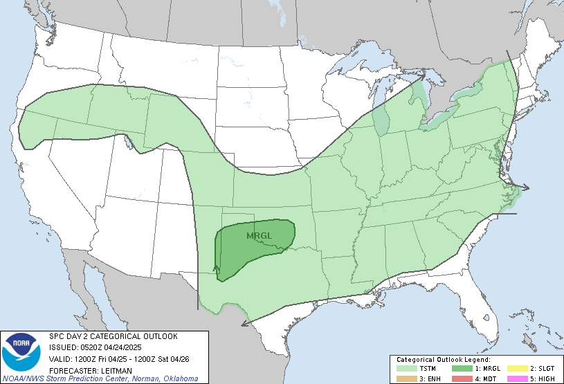
How about the risk of severe storms? The plains into the western Ohio Valley will be the areas to watch today…
That outbreak could get nasty as the squall line gets cranking. That line will be moving in here early Thursday but that is a bad time of day for severe weather and it SHOULD be weakening out before getting here. It will likely leave a few boundaries around that may fire up some afternoon storms. The Storm Prediction Center has us in the famed “see text”…
So… here is the text. ![]()
A PROGRESSIVE COMPACT UPPER-LEVEL TROUGH IS FORECAST TO MOVE EWD
ACROSS THE ERN GREAT LAKES THURSDAY. AN ELONGATED MCS SHOULD BE
ONGOING ACROSS THE OH VALLEY AHEAD OF A COLD FRONT THURSDAY MORNING.
MODEL FORECASTS SUGGEST THE CONVECTION WITH THE FRONT WILL DECREASE
IN COVERAGE BY MIDDAY. NEW STORMS SHOULD INITIATE IN THE AFTERNOON
FROM THE CNTRL APPALACHIANS SWWD ACROSS KY AND TN DUE TO LOW-LEVEL
CONVERGENCE NEAR THE BOUNDARY AND SFC HEATING. FORECAST SOUNDINGS
ALONG THIS AXIS AT 21Z THURSDAY SUGGEST ENOUGH INSTABILITY AND SHEAR
WILL EXIST FOR A MARGINAL SEVERE THREAT. THE ENVIRONMENT WILL
RAPIDLY BECOME UNFAVORABLE AFTER PEAK HEATING AS LOW-LEVEL FLOW
WEAKENS DUE TO THE EXITING SYSTEM OVER THE NERN STATES.
A few more thoughts…
1. This will be a rather humid air mass moving in here from late Wednesday through Saturday giving us a very muggy feel.
2. That same juicy air will lead to some proficient rain producers in any storms that go up.
3. We are likely to see a decent shot of chill coming in by Monday. Some upper 30s for lows early next week? Hmmmm
4. Why do I get the feeling that something tropical may form early this season?
Have a great day and I will update if needed. Take care.
Select Page
So far, this is like 2004 all over again in the LEX area. Wow.
At least the heaviest of the warm front precip is staying well off to the north.
Still hope the NWS is right from their statement yesterday, but I still think we will be keeping an eye on water levels Sunday.
Hey gang take a look at this it is pretty cool!
http://www.news9.com/Global/category.asp?C=167025&nav=menu681_3_7
SHEESH!!!…heavy rain, humidity, tropical development,and upper 30’s all in one blog post, all we need is some snow to throw into the mix…:(…how about some calm sunny 70ish weather like yesterday and most of today has been…:):)….
looks like a nasty storm getting ready to come through here. the sky is the darkest blue ive seen in awhile & its just now starting to thunder…
Bailey, it’s pool opening season, we simply don’t need 30’s for temps…come CB and mother nature, this cool spring needs to take a hike and NOW!!!! By the way, all the rain we are getting now, bet ya it’s bone dry this summer. It’s either feast or famine around this area.
That is so cool, thank God for technology. I want to go one one of them chase tour one of these days.
Those are some nasty looking storms in Illinois…hopefully they will die out tonight..