Good Friday afternoon, gang. It’s ugly out there! Rain, wind and chilly temps continue to dominate the weather across much of our part of the world. A huge storm system continues to develop across the Mid Atlantic and throw rounds of rain into Kentucky.
These rains will be heavy at times with winds gusting to 35mph at times. I can’t rule out a 40mph gust somewhere out there.
I’m finally liking what the GFS is cooking with the east coast storm and with Joaquin. The two stay separate with a Thewave of heavy rain working westward into Kentucky early Saturday…
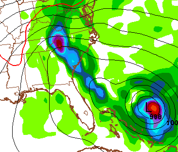
The model then brings that slow-moving band of heavy rain into eastern and central Kentucky through Saturday evening…
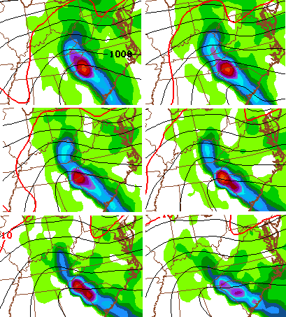
If that’s correct, local high water issues could develop. Check out the rain totals from this run…
Winds will continue to be gusty with temps in the 50s.
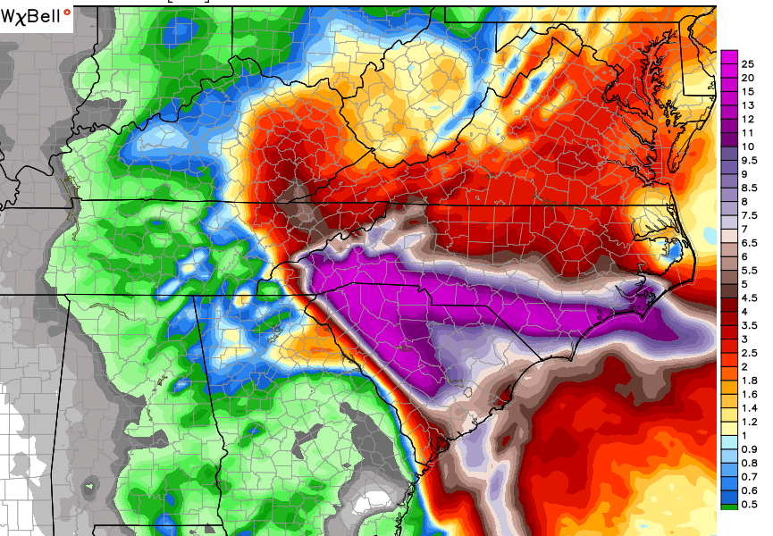
In case you missed it last weekend, here’s the map I created showing the pattern I thought would be setting up for today…

Not too bad… I’ll take it. Don’t hate on my shameless plug of my mad forecasting skillz. 🙂
I’ll focus more on where we go over the next few weeks with my regular late night update. Until then, track the cold Kentucky rain…


Take care.

I have corresponded before with NWS Jackson about dangers of landslides and mudslides during heavy rain events. While the one I corresponded with agreed that he thought about including such wording in Flash Flood products or as a separate product, I have yet to see any change in language. Concerning the potential danger that exists in higher elevations of Kentucky studies by the USGS show that there is a significant probability for such events during prolonged heavy rain events, such as occurred in the Spring.
So, here is a sample product released recently out of the Spartanburg SC NWS office to illustrate how easily it is to at least mention the dangers of landslides, rockslides, mudslides, in addition to flash flooding.
http://forecast.weather.gov/product.php?site=NWS&issuedby=GSP&product=PNS&format=CI&version=2&glossary=1&highlight=off
Well, here’s another one just across the state line out of Blacksburg VA NWS office for its Flash Flood product…
http://forecast.weather.gov/wwamap/wwatxtget.php?cwa=jkl&wwa=flash flood watch
sorry…
http://forecast.weather.gov/wwamap/wwatxtget.php?cwa=jkl&wwa=flash flood watch
One more time, if this does not work, it works well on my blog
http://forecast.weather.gov/wwamap/wwatxtget.php?cwa=jkl&wwa=flash flood watch
We need the rain but not the flooding. For this up coming winter from what I have been herring we are going to have the worst winter that we have seen in 50 Years.
Can anyone even try to imagine what it would be like if ever got the 25 inches + forecasted in parts of Western North/South Carolina here in the mountains of East KY?!!
“we” ever…sorry!
I am surprised that there are no flood/flash flood watches for KY as some creeks and rivers are already running a little high!