Good Monday, everyone. Back in late January, I highlighted the period of February 7-11 for the return of harsh winter weather. That time has arrived and we have a lot of harsh winter weather settling into our region. As a matter of fact, some of the current models are taking a big walk on the wild side over the next week.
There is so much going on, I’m finding it hard to highlight any one threat. This post is likely to be all over the place, so buckle those seatbelts and let’s roll.
Our first blast of winter weather is moving through early today with a band of rain and snows. Some slush is possible in a few areas, but the main bands of snow arrive late today into the evening. Between these two, temps will briefly spike, before they crash during the evening.
Snow showers and squalls become widespread later today and last through tonight and Tuesday. Early on, some thunder is a possibility! These squalls will have blinding snows and very gusty winds.
This action continues into Wednesday as arctic cold settles in. Temps on Wednesday may not get out of the upper teens for highs with single digit wind chills. Actual thermometer readings Thursday morning may drop into the single digits for many.
This is when we get another system to zip in from the northwest. That could have another streak of light accumulating snows. The GFS continues to indicate the snows add up from late today through Thursday…

Between late today through Thursday, this is likely to be a widespread 2″-5″ snowfall for much of the state. Lighter amounts will be noted in the far west, with higher amounts in the southeast. Again, this is not all falling at once and comes over the next 4 days.
A MAJOR blast of arctic air then arrives late Friday into the weekend. The GFS and Canadian Models show another round of snow with this…
GFS
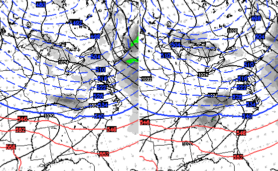
Canadian…
The European Model decided it wants to make turn that system into a full blown arctic wave snowstorm…
 Holy cow! Given the arctic air in place, that would REALLY fluff up and blow around. The European continues to bring, what amounts to, the polar vortex close to our region…
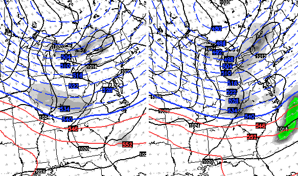
 The actual Valentine’s Day lows from the European Model via WeatherBELL…

Funny thing is, the European Model surface temps are usually biased warmer than what actually occurs.
The same model run then goes on to show another snow maker from Sunday night into early next week. It’s not as strong as the earlier run with that, but more than makes up for it with the Friday arctic snowstorm.
The Canadian Model still has a huge storm…

Watch that wrap up to our northeast…

For fun, here’s the what the Canadian Model shows for snowfall from today through next Monday…
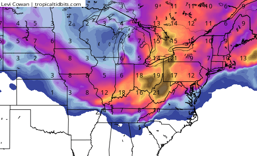
That’s just a snapshot in time of what a computer model thinks will happen, so keep that in mind. However, we are certainly seeing some extreme possibilities showing up on all the models over the next week. Like I said, buckle up!
I will update things later today. Until then, track winter back into the region…


Enjoy the day and take care.

hmmmm I don’t see a FIRST CALL SNOW MAP. to much punch at ur party Bailey Boy..lol
Oh my … I wonder how many days of school we might miss over the next couple of weeks …
Thanks Chris!!
Will I get out of school any this week? I need one day..please!!!!
Looks like a MISS for the Bowling Green area. I’m ready for Spring, but if its going to be cold, I want the snow! ha!!
Agreed, can’t believe we still haven’t seen a first call for snowfall map yet.. Oh well, keep up the good work Chris
Wow!
I think we dont need a first call for snow map.
1. Most of monday will be rain
2. Tuesday through Friday morning on off snow showers the map would be like placing small nickel and dines across a map of ky
Yep. Wind and the sporadic nature of the snow would be hard to peg a map. Mainly scenic snow, but slick morning conditions likely. If the snow stars were to align, this could be a creeper and surprise some folks. I think CB would be saying that though, if he thought it could be the case.
Interesting week or so of weather on the way! Rodger loves snow squalls; they’re like being in a snow globe! He’s also hoping we can get a southern system to roll this way while the cold is in place. Fingers crossed for another BINGO snow this month! Rodger in Dodger
Is the Candadian ever correct? I hope it is this time. Even a blind squirrel finds a nut now and then. No first call map as BengalFan said nickel and dimes all over. Or better yet pennies and nickels all over.
OH THE SNOW MAP was after the SUPER BOWL on TV.. hmmmmm I don’t have cable Bailey.. cmon man!!!lol
All u need is rabbit ears to get wkyt, come on man, lol
no way for a 1st call snow map to work with the snow makers we got moving in the next couple days
rain/snow mix here in Athens Ohio
This deserves and old school Harry Caray “Holy Cow!!!”
Thanks for the great update, Chris.
The last snow we had…that’s enough for me. I have no four wheel drive and I live on back roads. So…every time it snows, I can’t get out while everybody else on the main roads are roaming everywhere. I’m ready for spring. Winter just slows down all of my plans
looks like early March in Kentucky is going to be very warm …..
http://www.accuweather.com/en/weather-news/2016-us-spring-forecast-march-snow-northeast-widespread-severe-weather-april/55085474
Just picked up a quick 1/4″ deck duster in Metro Lou. South of the city looks to have picked up a little more. Looks like a few more squalls later this afternoon.
I drove through the snow shower in the southern part of the county on the work to work this morning. Rain at first, then a quick change to large, fluffy snowflakes. Didn’t stick to the road, but very pretty.
I’m fearing the NW shift on that monster next week.
These little squalls probably won’t amount to much. I’m fearing I won’t get much use out of the snow boots and sleds. And my kids are probably getting out in May like they’re supposed to. Bring on Spring!
Your fear in this is my hope. Much different perspective 🙂
Haha
Big, huge FAT fluffy snow for about the past 20 minutes here in La Grange….
look at all that blue turn to green on the radar right now. Nice!
That green was heavy wet flakes here in the Metro.
Sun shining nice and bright driving up I-75 from Williamsburg to Corbin, no rain or snow to be seen.
It’s coming tonight but most other weather outlets are already downplaying the treat for anything significant…at least in the southern counties
Thelma Lou would love to see about a 5 inch snow Friday night…just in time for Valentines weekend. I have a feeling that snow chances will melt quicker than a box of chocolates left out in the car! Guess I better order some flowers.
@Clays Ferry…Just started fat flakes of snow coming down with little wind…then eased up or should I say teased up! This is another fun multi-day event.
Light snow/sleet mix falling west of BG in Warren Co.
Chris,
Google marks your site as “This site may be hacked” in search results. Might want to check that out.