Good Friday, folks. We have a bitterly cold air mass sweeping into the region to start out the weekend. This is being introduced by a period of light snows this morning, with snow showers waiting in the wings for later today into tonight. From there, it’s all eyes on how much of an impact a developing winter storm will have on our weather.
Let’s start with today and roll forward. Light snow across southern Kentucky can put down some light accumulations to start the day. After that moves away, the arctic front then drops in from the northwest with snow showers and some squalls breaking our in central and eastern Kentucky. This action can put down light accumulations into Saturday morning.
Temps by tomorrow morning will drop into the high single digits to low teens. Gusty winds will make it feel MUCH colder than that. Wind chills from 0 to -10 will be likely across the state. Highs on Saturday will generally range from 15-20 with a wind chill near zero.
This brings us to what you are all really here for… the potential for a winter storm to impact our region from late Sunday through Tuesday. I want to see how the early day model runs look before a full blown upgrade to a Winter Storm Threat. There’s still just enough wobble potential to keep me from pulling the trigger. This is actually very common among models in the 3-4 day window.
That said… I do expect this winter storm to impact the region. I just haven’t honed in on to the exact extent.
A swath of accumulating snows move across the state Sunday into Sunday night. Once into Monday, the main storm forms and likely works across the Tennessee Valley and into the Mid Atlantic states. The exact path and strength of that low determines how much snow you get where you live.
The European Model gives us a very slow moving storm with a secondary system diving in behind it…
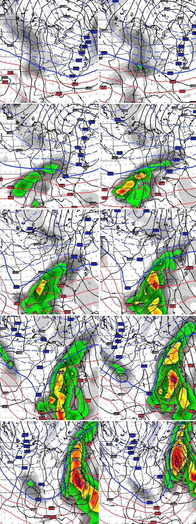
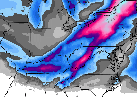
Verbatim, that’s snow to heavy snow to a mix then back to snow for many areas of the state. The accumulations from that run courtesy of WeatherBELL…
Here’s the track of the low from the GFS Ensembles average…
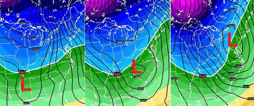
That track is usually a big snowmaker for our part of the world.
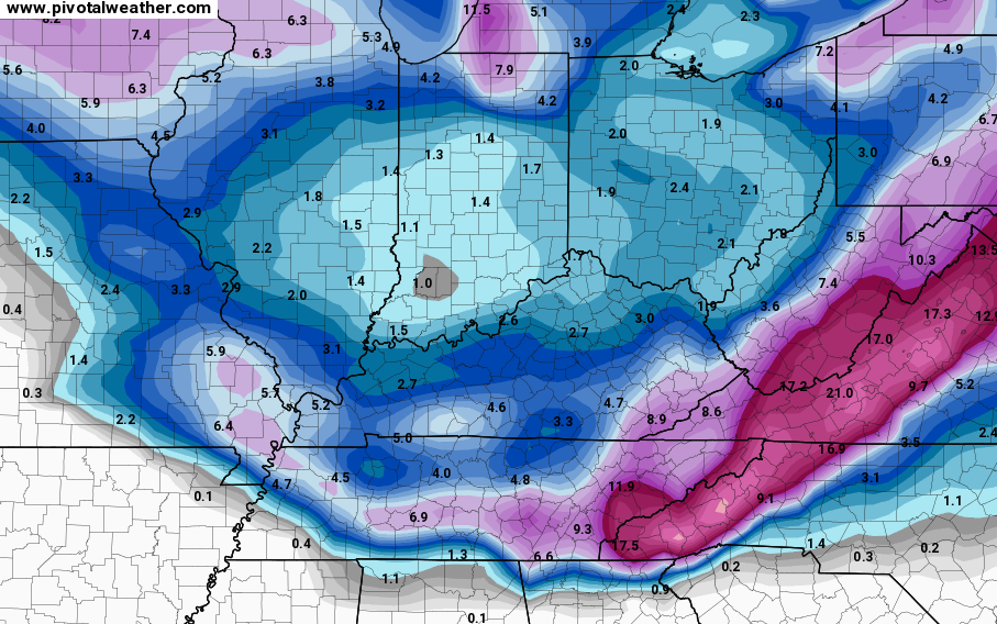
The latest GFS continues to have some issues. Each run is vastly different from the run before, especially with the low level temperatures. The latest run brings snow across the state Sunday and Sunday night then focuses most of the precipitation across eastern Kentucky. Here’s the snowfall from that run…

The Canadian Model gave us a rather convoluted solution…
As you can see, it’s clear we will be impacted by a winter storm. The extent of that impact is what I have to figure out.
Updates on this whole setup will come later today. I leave you with your Friday tracking toys…


Hamburg Area from WKYT Studio
Lexington

I-75 @ Winchester Road
Lexington
I-75 @ Iron Works Pike
Lexington
I-75 @ Clays Ferry Bridge South
Between Lexington and Richmond
US 60 @ US 127 Frankfort

Mountain Parkway near Slade

I-275 approaching KY 20/Airport
Near Covington

Downtown Louisville @ 2nd & Broadway
Louisville

I-64 @ I-264
Louisville

I-264 @ Freedom Way
Near Louisville International Airport

I-75 at MP 36
London

I-75 at MP 23
Corbin
-65 @ 234
Near Bowling Green

Natcher Parkway MP 5
Near Bowling Green

Enjoy the day and take care.

If all snow Monday, 2-5″ the way it looks right now. Nothing major. Of course it could change and miss us entirely. Still 3-4 days away.
I know that you can’t watch any other main stream source right now because they, not mentioning names, have KY getting mostly mix to a cold rain with hardly any accumulations at all. I am sticking with CB but still nervous that too much warm air could destroy this system. This may be a Pandora type system where many see freezing rain/sleet change to rain while cold air stays strong enough entrenched that a few areas see several inches of snow before a change over. I sure hate to see the warm air come in so fast next week. Regardless of whether or not we see several inches which I hope to see, the huge warm-up next week will quickly wipe it out:(
If no ice, call it a win regardless of what falls 🙂
Ugh ugh ugh. It looks clear either way ya go that the West Virginia corridor is going to get blasted with a mess. I mentioned before that I’m supposed to be having surgery Monday and leaving Tuesday for DC but that does not look like a safe bet at all. Anyone have thoughts on the timing for Monday? If we were to leave Lexington mid-day Monday do you think we could make it through West Virginia and into Maryland before this thing hits?
Yep. You guys to the east NE can have the shoveling 🙂 😉
Rooting for more of a mix myself. 😉
This! Just say No to shoveling snow 🙂
Seems mix will be a key word, the more south you go. The warble CB mentioned will make it hard to peg totals, even 24 hours before. I am concerned about Ice becoming a word in the forecast, so hoping just my paranoia.
Stay safe Monday friend.
Fortunately I will be home then, so it’s all good in my hood.
It is strange that despite the track of the storm and all of the super cold air ahead of the storm that we are even talking about a mix or rain. I’ve always thought that if the storm tracks south, the northern edge gets snow, especially with how cold it has been.
What are the odds that the eastern shift last night comes back west today?
Wait for the model runs. Can’t wait regardless!
All rain for ky. Even a mix far north as central ohio.I don’t see any ice or snow accumulation at all for the entire state of ky.
wow, I wish we all had a crystal ball like the one you have!!!! This is the only comment I will leave for you, it seems like your wanting someone to comment, so I felt bad that nobody had
CB personally shot down that scenario yesterday when the same post was made. Don’t know why they keep posting it again.
Lol! ZING!
The weather channel says same thin as well as accuweather and local channels. With temps in mid to upper 30s commen sense has to kick in.I’m not looking for response just stating facts.
I would not in any stretch call accuweather and the local channels cloning them to be common sense. I would though call it lazy forecasting, or the blind leading the blind.
Whatever the case, no ice = win.
As a longtime reader of the blog, I’ve learned to pay attention when Chris says “arctic air doesn’t get pushed around easily.” The weather models from the computers don’t detect this, and spit out a forecast where the temperatures are higher than they actually end up being. Moral of the story? It’s too early to tell either way.
Therefore…my current concern with this system is the possibility of frrezing rain.
chris,
you are allways right about winter stroms
Thelma Lou says artic air can be a little bit stubborn & don’t like getting pushed around. That being said temps are forecast so warm in Southern Ky that even an 8 degrees lower than currently forecast temperature swing would still result in rain.
right now they are calling for 1-3 in my area, Athens Ohio and a High of 40 on monday and Tues
Clipper system gave me about 1/2″ snow this morning here at watts bar lake in east tn..moved a bit further south than expected.. Hopefully that will be trend with next storm as well we have missed all the big snow makers this winter so far.
there is nothing to look at here folks… the weather has harlan ky and london ky rain and lower 40s monday and tuesday… so its not going to snow ….. period
LOOK! Bowling Green is winning the snow award on the live cams so far this morning 😉 pretty flakes fallling down!
Just started snowing here in northern Clay county!
Also here in Knox.
6=10 for SE Ky..
Faith in the western shift I have.
Snow we will have.
To rest doubters will be.
The “low” is strong with this one.
All we can do is sit back and watch. The weather is the one thing left in life that money and politics haven’t corrupted 🙂 Rodger in Dodger
I agree
also, weather is the one thing that no one or no cumputer will ever be able to accurately predict “100% of the time” no matter what technology comes down the pipeline in the future. Mother nature will always have the last laugh.
Thanks for the great update Chris. I like how you explain the different scenarios.
I’m getting a big kick out of the early predictions from the posters.
Fun stuff!
How does the stuff on radar not show up in the air? I know this has been explained before but I can’t recall. Warm air aloft? Or too dry?
Looks impressive on the radar. I wouldn’t mind a little preview of what’s to come!
Dry air.
Dry air aloft causes the precipitation to evaporate before it hits the ground. The radar beam is detecting it in the air, but it never reaches us on the ground. It’s called virga.
Beautiful fluffy snow covering Laurel County. Looking lIke about an inch so far.
What time do new models run?
I think the 12Z runs are something like this: GFS is around 11am, Euro around 2pm. When the NAM gets within range, its 12Z run is around 9:30am. I may be a little off but those seem about right!
CB pretty much just tweeted that Kentucky is going to get some snow and another system might even throw some in on Tuesday-Wed. Three shots of snow from Sunday to Wednesday. I hope it’s a good snow for much and lets move back to normal highs in the 50s. Bring Spring (after one more big snow)
Waiting for the wishcasting from the SEKY Crew.
Realist here saying it will be more rain than snow for SE KY . How’s that 😛
I seriously believe this will be mainly rain and freezing rain for most of Kentucky. The track through Tennessee and up the mountains is usually a great track for snow, here. But I`m sensing rain……………..I want all snow for Shepherdsville though and lots of it………….a foot or more.
I felt better about the Monday storm a day or two ago. All the locals in my area of WV keep raising the temps for Monday and Tuesday. This seems like a repeat setup to the storm last year that came between the two big ones. Temp went from – 15 to 35 in less than 24 hours in my area and I got almost 2 inches of rain.