Good Saturday, everyone. I’ve decided to upgrade to a Winter Storm THREAT for late Sunday into Monday. This is for the potential for four or more inches of snow falling across parts of our region. If my confidence increases, we will upgrade to Alert status. If it goes the other way, the threat will do the same.
Let me be clear off the bat that I do NOT expect this to turn out anything like our recent winter storm, or any of the storms from last winter. All Winter Storm Threats are not equal. 🙂
The overall setup of the Sunday through Sunday night part of this storm continues to be similar to what I have been describing of late. Snow develops from west to east Valentine’s Day afternoon and evening. The latest models are fairly impressed with the snows. Here’s the NAM…
 That run of the NAM even shows the potential for thundersnow in Lexington Sunday evening…

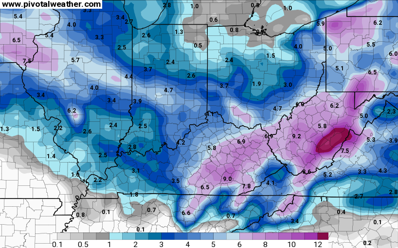
Here’s the NAM snowfall forecast by Monday morning…
 Again, that’s JUST a model forecast.
The NAM goes on to keep the Monday storm system across central and eastern Kentucky. By this time, it shows more of a mix of precipitation that tries to be just snow in the heavier band…
 That then adds to the totals across the eastern half of the state…
Again, that is JUST a model forecast.
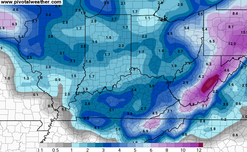
The European Model holds steady with what it has been showing for the past few days…

That’s a healthy swath of snow statewide Sunday into Sunday night with 4″ or more for many. The model does bring a mix into the equation on Monday before going back over to snow before ending Monday night.
Snowfall from the model…

The GFS handles the Monday system totally different with each run. That makes it very hard to use, but it does have the Sunday afternoon and night snowfall…
I will have updates later today and get some new snowfall forecasts out. Some tracking tools until then…


Stay warm on this Frigid day and take care.

Looks like much of nothing… So glad spring is around the corner.
nah, just a potential winter storm….
I have my water running in hopes that it won’t freeze off again.
I wouldn’t get too used to the milder air coming in late next week…I still think Old Man Winter has at least one more dart throw coming around March.
Last two runs of the NAM hinting at Winter Storm Warning criteria for areas along and east of I-65….Still rather wait and see what 12z run has to show, that 24-36 hour window is usually the best run for me.
Catch is how much of the precip falls as mix.
I meant for the just the Sunday time frame, which should be mostly snow for our areas between Louisville and Richmond. In fact areas of south central Kentucky might see the most.
So whatever snow if any falls gets washed away for sure Wednesday if the models are right
Yep. Snapchat snow.
…and of course much of Tennessee may get the freezing rain threat. At this time, it may not be enough to cause many power issues. But we know too well that it takes very little ice to create havoc on the roads. I don’t know if road crews can pretreat roads before any freezing rain starts, but sure hope the ice threat will be short-lived. Nashville’s big snow a few weeks ago was made worse by the steady rain changing quickly to snow (no pretreatment was possible, then the rainwater froze up on the roads).
Looking forward to the much warmer temperatures later in the week 🙂 . But as Mike S touched on, the signs may be that winter could return at least one more time.
Thanks CB!
That is what happened in Knoxville Jan 96 when I was living there. It absolutely poured rain (about 2 inches) then that switched to about 6 to 8 inches of heavy snow, followed by bitter cold for a few days. The result was packed ice/snow on main roads that could not be scraped. It was so weird driving on them
I wonder if any of you guys could point me to the best website to gauge the prediction of the hourly timing of this Sunday storm’s arrival? I am going to be traveling I-65 and want to avoid it as much as possible.
Thanks in advance! 😀
The best option for you is provided by the national weather service. Find the forecast for the particular area on the nws website. There will also be a graph (usually in the bottom right corner) that shows expectations for every hour of the forecast period including temp, wind direction/speed, amount of precip and type of precip. It’s updated often.
In a tweet yesterday, CB mentioned another snow system for Tues and Wed. Is that still a possibility?
Thanks Chris. I have a qurstion fior anyone… With snowfall first and then a wintery mix, and back to snow, chances for very icy conditions are growing, right? Or is my thinking a little bit off? Also, is it time to run out for milk and bread yet? ;). Have a great Saturday everyone and GO CATS,!!!
Hi Coffeelady. I’m with you on the mix sandwich. I’ll take an app of snow and then snow for supper and dessert.
Hi Coffeelady. Let’s hope the mix threat won’t have a very high freezing rain to sleet ratio! Anyway, the Weather Prediction Center feels at this time that Kentucky in general will have a somewhat lower ice risk then, say, Tennessee (for both storms). It will be interesting to see how much this risk may evolve the next few days.
It’s looking like areas on the east side of the Appalachian Mountains (like western North Carolina) may get the brunt of the freezing rain threat as a typical “cold air damming” setup may be in the cards there.
Accuweather snowfall forecast Paducah 2-4, Louisville 3-6, Lexington 4-8, Cincinnati 3-6, Ashland 1-3.
The name Accuweather for that site has always struck me as ironic 😉
Thankfully the temps didn’t pan out down here as predicted.
Huh oh. Looks like the dreaded wedge is about to rear it’s ugly head for WV and SE KY. Oh well I guess we had our one in 10 big one a few weeks ago, now back to normal.
Not everybody got the big snow a few weeks ago
or a big snow last winter either.
Yeah, places like Middlesboro got less than 6 inches in spots. I ended up with about 10 inches here in Harlan, so the last few winters have been much better for big snows but nothing like the 90s.
SE KY HAS STILL MISSED THE VERY HEAVY STUFF LIKE THE ACCUMULATIONS FROM THE 90S TYPE OF STORMS!!!
WE ARE GOING TO GET ONE THOUGH, EVENTUALLY:)
Anybody else notice the weather links on the left nav are no longer working?
Its been that way for a while. The NWS has moved or changed the links and nobody has updated them with the new links on the blog.
Ready for some snow tracking and ready for the Cats on the road.
Go Big Blue!!!
Thanks Chris.
Louisville is saying 2 to 4 inches Sunday, it looked like temperatures rising through the night and 36 on Monday with rain. So if we do receive snow on Sunday, it`ll be gone by Monday afternoon.
I’d like to see a little more NW shift please
Cats by 8
About 6 hours ago, graphic from Weather Prediction Center shows a moderate chance of at least 4″ exists just south of Louisville.
http://www.wpc.ncep.noaa.gov/wwd/day2_psnow_gt_04.gif
It is still an interesting set-up but a little run of the mill for my liking:P
Either way, the mix or even plain rain will likely ruin a lot of Sunday night’s snow in most of Eastern KY and possibly most of Central KY, then (IF) we get some good heavy, wet snow later Monday, the whole event will be a distant memory by Wednesday/Thursday. Next week is just going to be too warm, but winter is not over yet. Like most are thinking, I think we will have a least one or more big storm threats yet.
Here is hoping for a foot of snow before the warm-up:)
There might be a few colder days scattered around, but for the most part the transition starts around this time. Next week average highs hit 50 here in southern Kentucky. I’m looking forward to getting outside and picking up some of the limbs in the yard to get ready for mowing season. It’s almost time and I can’t wait for the warmer days.
NWS offices in Jackson and Louisville basically saying 2″-4″ by Monday morning area wide with a touch more in southern ky. Then snow to mix to rain Monday Temps near 40 Monday.
I predict we will see nws issue winter storm alerts of some type by 2 this afternoon. They likely want to navigate through the noon models before making a final decision on the type of alert.
Yes if any snow falls, no matter how deep, it will be quickly gone. From what I understand, snow pack can keep the air really cold and cause temps to take a dive UNLESS there is a south wind……A potential snow storm is just not exciting to me at all if this is the case…I mean, I’m still interested in watching it play it and see what happens, but the level of excitement is nothing compared to the last 3 we’ve had (for me anyway)
I’m flying out for Las Vegas from Cincy next Friday so I hope we get a lot of snow here in Pike County but I’m glad it will be warming up somewhat by the middle of next week so hopefully the main roads won’t be bad by then and I can have safe travels.
From Sunday thru Tuesday I hope we see a nice healthy snowstorm but I’m afraid the dreaded cold rain will show up.
I think the only reason why no winter storm watches have been issued is the fact that there is no real model agreement and the overall runs keep lowering the totals. It starting to look more like a winter weather advisory kind of storm with only parts of the state getting into the winter storm criteria. I am not impressed with what the temperatures look for most of KY on Monday, especially the southern half maybe pushing 40 degrees:(