Good Tuesday, everyone. We are coming off a night of strong storms and high water issues, but the weather looks better over the next few days. There’s a southern system that may give us a brush with rain Thursday, but the pattern is mainly dry until next week. Temps will do a little roller coaster during this time.
Severe weather hit areas of western Kentucky earlier Monday evening, with Tennessee taking the brunt of the severe weather. A devastating, long tracked tornado ripped through the Nashville area.
Some parts of Kentucky have picked up more than 3″ of rain and flooding is ongoing in some areas this morning, so let’s keep that in mind. Here’s a look at the current warnings…

Here’s our regional radar to track the rest of the action out of town…

Once the leftover showers and storms move away this morning, the afternoon looks really good with temps hitting the 60s with a mix of sun and clouds.
A little cooler air seeps in for Wednesday, but things remain dry. The Thursday system could still bring the potential for some rain in the south and southeast, but it’s missing the connecting flight with a cold front dropping in from the northwest…
 That’s a cold shot of air coming for Friday and early Saturday, but things turn much milder later this weekend into next week.
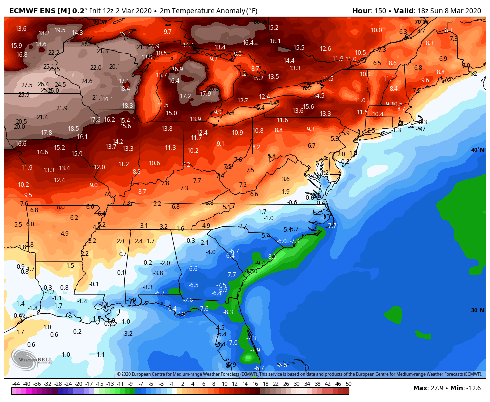
The overall trend continues to be warmer than normal through the middle of March on the Euro Ensembles…
 I will have updates for you late today, so check back. Until then, have a good one and take care.

Just looked at the pictures of the aftermath of the early morning Tornado that occurred in Nashville, Tennessee. I’m worried about TennMark and his family. I pray that everyone is okay. Please let everyone know TennMark if you are able to read my post.
I was thinking the same thing. I HATE severe storms and I’m so sad winter is almost over 🙁
Let us know if you’re ok.
I will never understand why some people get so excited about tornado season.
Im guessing it’s the adrenaline rush of storm chasing. Me personally I think tornadoes suck!!
The only thing that is worst is earthquakes.
Hard to take precautions for that event.
At least hurricanes you can plan for the worst.
Im sure many people would also say why do some people get so excited about Winter Season? Winter weather always has and always will kill more people and cause more property damage than Tornadoes.
What a narrow minded comment! Especially at a time like this. Perhaps later, convince us by means of your STATISTICS next time that winter weather ALWAYS kills more people and causes more property damage than tornadoes.
He is probably should of said that winter weather kills more people than spring weather.
Me personally I will take a blizzard any day over a tornado.
He also fails to realize tornadoes occur year round, including winter. Winter Weather has a more limited time frame
Thanks, Schroeder and others.
My family and I are good, as we’re actually well south of downtown; it was the north edge of downtown Nashville on north that was affected. I still went to work today, in fact. We sure were ready to bolt into our cramped crawlspace with our daughter. But while our power flickered several times, it never went out.
Putnam County TN (includes Crossville up on the Tennessee Plateau) actually by far has the highest fatality rate even though much of the attention has been focused on Nashville.
As Chris Bailey touched on earlier in a tweet, kudos to the New Channel 5 (Nashville’s CBS affiliate) mets/reporters and other area mets that somehow kept a lot of their cool even as the tornado roared just outside. Wow!
Brain cramp.
I only grew up in Tennessee, but of course it was Cookeville TN that was devastated, not Crossville TN. Still true that Putnam County (includes Cookeville) has by far the highest tornado fatality count of any Tennessee county from the March 2-3 storms.
Crossville is actually in Cumberland County TN, closer to Knoxville.
Lots of rain, and small hail last night in WKY.
Wow, it’s rare that a tornado of that strength happens in the middle of the night like that, but it can indeed happen. Obviously, that’s the worst time for a tornado to occur, since so many people are asleep. A NOAA weather radio is so valuable for a situation like that.
According to usatoday.com, at least 19 people have been killed from those deadly storms and tornadoes to hit the Nashville area overnight.
Very sad and tragic. All the best thoughts and prayers to TennMark and his family, and everyone else there.