Good Monday, everyone. It’s the week we say goodbye to April and hello to May. As you know, April has been a pretty active and ugly month with a few severe weather events, above normal rains and below normal temps. I guess it’s appropriate we have the potential for severe storms, rain and below normal temps before the month is over.
Let’s begin with a little good news and that’s the weather out there today. Skies become partly sunny with temps reaching the 60s across the entire state. Even warmer air moves in for Tuesday and it could be introduced by a couple of thunderstorms. Temps reach the 70s on a strong southwesterly wind.
Those winds are along and ahead of a strong cold front sweeping in here Tuesday night and Wednesday. The potential for strong to severe storms will be possible along and ahead of this…
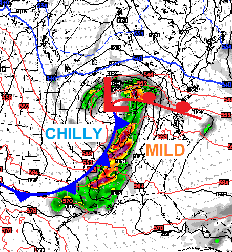 Here’s where the Storm Prediction Center is highlighting for possible severe weather Tuesday…

Here’s the Wednesday Severe Weather Outlook…

Temps will come way down behind this system as an upper low spins right on top of us. That allows for showers to linger into Thursday, the final day of April, with temps only in the low 50s for some.
As May begins on Friday, the sun returns and temps make a big jump. That sets the stage for a surge of warm air this weekend into early next week. This looks to be accompanied by a pattern that can include multiple waves of thunderstorms, some of which could be severe…

Make it a great day and take care.

Thanks Chris, Storm totals yesterday at 1.39 inches of rain in my backyard. Indeed one of the coolest and wettest Aprils that I have ever experience. I don’t recall the exact year, we had in southwest Indiana one of the hottest Aprils and driest I have ever experience. This just goes to show that April can have the extremes of March. I certainly hope that May shows some signs of a pattern change to the warmer and drier, but at this time this holds very little promise.
I see Lexington has had 15 days in a row where the average temperature has been below normal (and 17 out of the last 18). Maybe that will change this week…
…and at the start of April the forecast models said April would be warmer than normal.
You can always bet when the SPC has the worst of the severe weather south of Tennessee, that Kentucky won’t get any severe weather.
Record low tied in Lexington today. 32 degrees.
Nashville dropped to 37 this morning, but calm winds resulted in some frost on the outskirts….apparently outside of the “heat island” effect. Clarksville TN recorded 34.
Hard to believe today marks nine years since the 2011 Super Outbreak of tornadoes which devastated several states including AL, GA and TN. 2011 rivaled and in some ways exceeded even the first Super Outbreak (1974). Back in 74, Kentucky and Tennessee were two of the hardest hit states as those old enough to remember know only too well.
That was a horrible day Mark.