Good Monday, everyone. We have another storm system ready to rumble across the region through Tuesday, bringing the potential for more big storms in the west. As the week wears on, our temps return to much chillier than normal with a flat out cold pattern settling in by the weekend. That’s when record lows will be possible.
Let’s begin with what’s cracking out there today. Temps are in the upper 60s to low 70s for many, with thunderstorms flaring up in the west this afternoon and evening. That’s an area the SPC is highlighting for more severe weather…

Those showers and storms roll through the rest of the state tonight and Tuesday, with chilly showers trying to follow that up for Wednesday…
 Temps for Wednesday and Thursday will be well below normal, but look to only be an appetizer to what’s coming this weekend. Folks, this is a setup that’s straight out of the winter months and is one you really never see this late in the year.
A chilly rain maker moves in here by Friday, with cold air diving in behind it this weekend. Check out the amazing look on the EURO…
 Yes, that run joins recent runs of the GFS and Canadian in showing the potential for historic snowflakes possibly showing up…
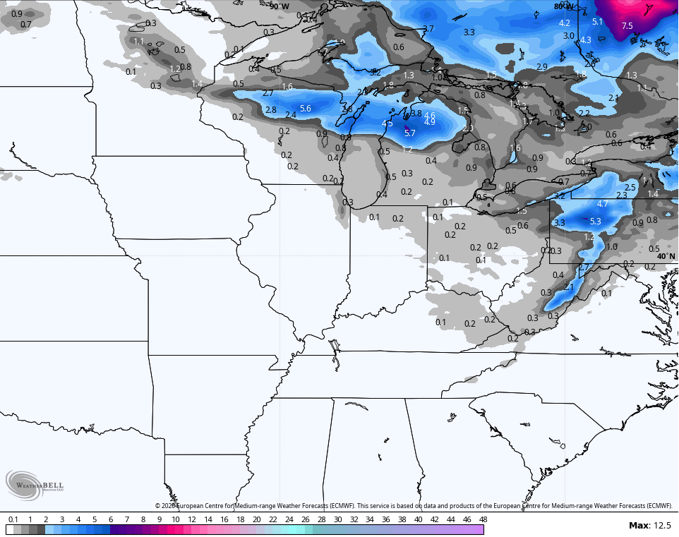 The chance for any flakes actually showing up is very small, but it’s incredible to see forecast models actually showing that in the middle of May.
It shows just how anomalous of a pattern is setting up across the eastern part of the country. What I think is most likely is frost and freezing conditions. Historic lows are possible on more than one occasion.
The GFS continues to bring 20s in here for Saturday morning…
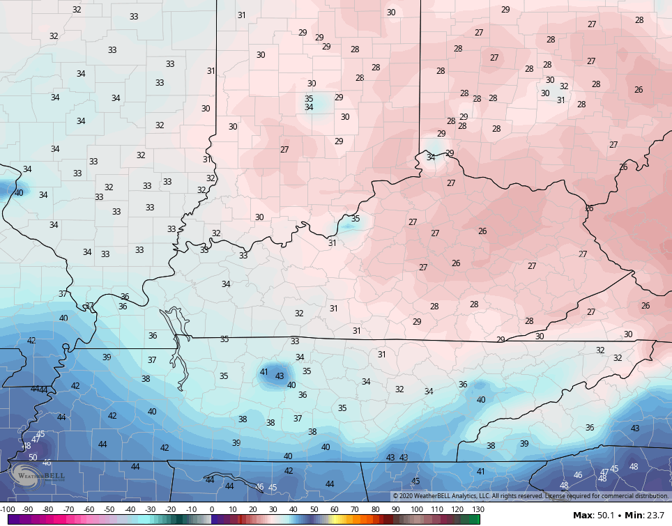 The model then does it again with another cold shot by next Tuesday morning…
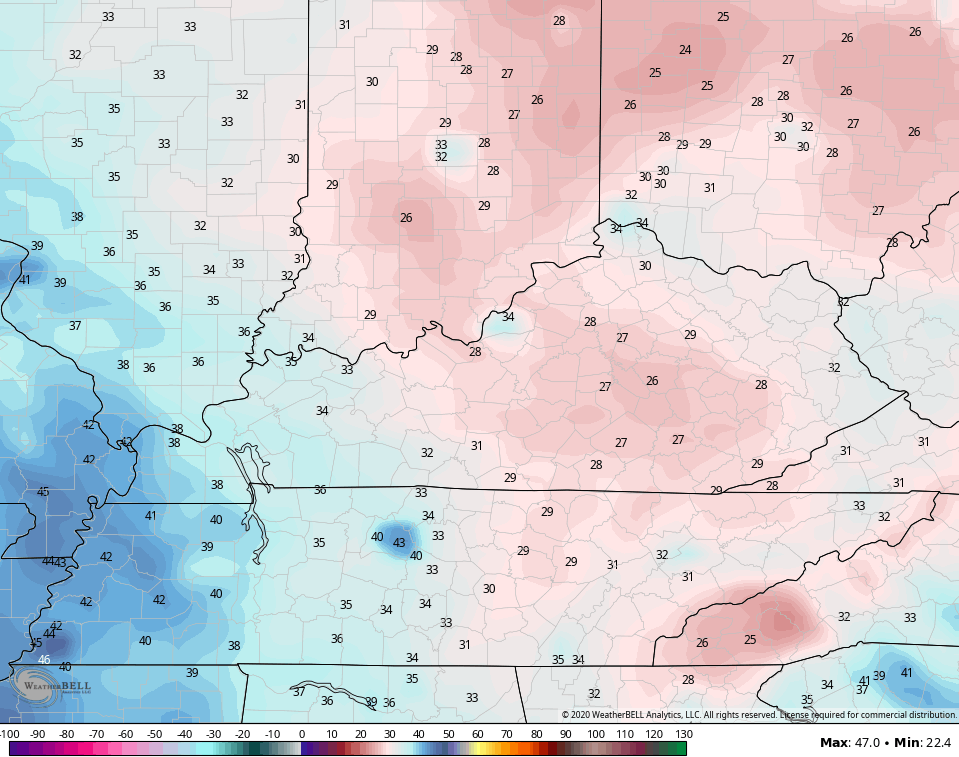 Folks, if any of these numbers verify, it could potentially be devastating on green thumbs and farmers who already have some crops in the field. Here’s hoping this pattern flips quickly!
I have the tools you need to track today’s action…


Current watches

Possible Watch Areas

Make it a happy Monday and take care.

Thanks Chris, and a happy Monday to you too. I have been studying the Arctic Region since late Winter and have read that changes are taking place with the Polar Low ( or some may call it the Polar Vortex. )Meteorologist, are detecting a slight weakening of the Polar Low and with the westerlies decreasing is allowing colder air to move further south into the United States. Interesting read, but not understood why this is happening now in the month of May. My rhetorical question is why didn’t the above happen in December through February ? On NOAA prediction for next Autumn and Winter is a continuation of ENSO neutral which is another repeat of this past Winter. Apparently, NOAA has not for some reason factored in the current changes now taking place in the Arctic Regions. Maybe on their next run changes will show up in their predictions for next Autumn and Winter and the eastern half of the United States will have a colder drier Autumn and Winter 2020-2021.
Rainfall totals in my backyard from yesterday 0.58 inches. Late afternoon Sunday we had a weakening line of storms come through Taylor county with some high wind gust along with a brief period of heavy rain and pea size hail. Biggest storm so far this Spring here in Taylor county’s north side. If the models on a ” May hard freeze” pan out it would be a disaster not only to crops but to native trees and shrubs. Lets all pray that this doesn’t happen. We do not need this on top of what is happening to our economy. Ugh !
maybe my mind isn’t what it used to be but I can remember my grandfather, who was born in 1915 saying the latest he has ever seen it snow here (pike county) is may 7th. he said he was a young man in his early 20’s. the last time I remember this cooler than normal pattern in may was 1999. my sons birthday that month. I recall he couldn’t wear shorts because it was so cold. I recall having conversations about the weather saying we don’t think its ever gonna warm up this year. but this year is something special for sure. historic and potentially devastating for farmers & vegetation. ….and I cant stand it.
Where was this pattern during the past winter?
Good question that can’t be answered.
The Farmers and Gardeners ( if it does freeze this coming weekend ) will still have time to replant, especially soybeans and sweetcorn. Cold crops in the ground now can be mulch heavily with straw and come through without harm if freeze warnings are issued. Mother Nature will help the native vegetation recover.