Good Thursday, everyone. IT’S WARM OUTSIDE TODAY!!!! I feel like climbing to the top of the WKYT-TV tower and screaming that to the world. 🙂 This warm air is settling in through the weekend as humidity levels also increase, leading to the potential for a few rounds of showers and storms.
Temps today are in the upper 70s to low 80s for highs. Southwest winds are going to be cranking and there’s the chance for a storm or two going up…
Temps are in similar fashion for Friday as we get a little better shot for some storms going up. The threat for a few storms will take us into the weekend as temps continue to take off. The numbers may reach into the low and middle 80s…
The best threat for storms will come from a cold front inching in here by Sunday night and Monday. At any point through early Monday, storms could be strong or severe…
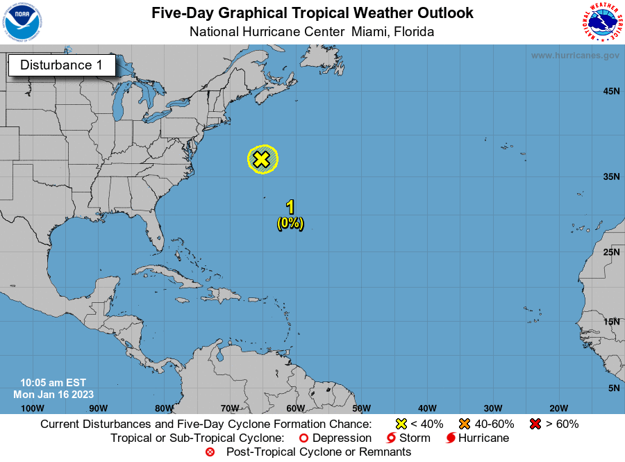
At the same time this is happening, a tropical system may get cranking off the southeastern seaboard. This is the early season development I said to watch for and it’s something we have been seeing more and more frequently of late. The National Hurricane Center shows the area of interest…

With the system working through here early next week, there’s a chance it absorbs that into a major east coast storm that lingers a while…
If that’s the case, our numbers would come down a little for the middle of the week, but would rebound quickly by the end of the week into Memorial Day weekend. That’s when some 90 degree thermometers may show up.
Make it a great day and take care.

Thanks Chris, You called it in an earlier blog that the tropical systems in the Atlantic would start early. Good Work Chris ! I am going to enjoy the early Summer temperatures but may have to dodge the showers this weekend.
On another note after using my horticultural knowledge, the native trees and shrubs suffered no damage from the recent hard freeze, however landscape plants that are not native and somewhat not hardy suffered, but in my opinion they will recover quickly.
Still waiting for that first official 80 degree day in Lexington. We are only 8 days away from trying the record for the latest. If not today, it should happen sometime between now and Sunday.
I don’t think we have had an 80 degree temperature so far this Spring here in the hills of Taylor county, and meteorological Summer begins June 1st.
Just got back from a walk down to the “mail box row” no mail, but I got my dose of vitamin D. Nice day, but very windy.
The Lexington official thermometer seems to run a bit cool..high of 79 as of 4:30 P.M. The Fayette County mesonet site has hit 80.
Well, it’s always run hot in the past. Chris has complained about it forever for running hot……..said they may replace it. I wonder if they did?
chris, im right there on the tower with you. this is amazing.
A Flash Flood Watch is in effect from tonight through tomorrow morning for much of the Chicago Metro Area, as most of the area had between 1 and 1.25 inches of rain earlier today. 1 to 2 more inches, with locally higher amounts, is predicted to fall tonight and overnight into the morning. The severe weather threat is low though, with just a marginal risk. There’s a better severe weather threat further downstate.
It’s a nice late afternoon now, with temps around 70 and a sun/cloud mix. Nothing is imminent on radar, but that will change after dark.
It was low 80s in Richmond today. So perfect.
Thanks Chris. Lad to see such a waitifl say! We needed one or 2 or 3 dozen! Was wondering if we were ever going to see spring. Nice to see folks taking a walk (with masks on, of course). And neighbors waving and speaking to neighbor. A hint of normalcy. Hopefully we will keep the warm weather for a while. Sure hope so. Enjoy it! And be safe. Out there!
The severe weather threat has been expanded further north than they expected tonight and overnight. The Severe Thunderstorm Watch that had been in effect for NW and Western IL until 1 AM has been extended East to include the SW suburbs of Chicago, including my county, Will.
There’s already been a Tornado Warning issued for the areas just to the NE of Peoria, and the radar looks really impressive with a strong cluster of storms approaching the Mississippi River in NW and Western IL, along with the tornadic storms NE of Peoria.
We were overdue for the severe weather, as the only previous episode of severe weather here in the Chicago area was over a month ago on April 7th.