Good Tuesday, weather weenies. Here’s hoping this finds each of you well as you travel down the highway of life. As we continue with our run of summertime temps, we are seeing the beginning of a change blowing in out there today as isolated storms kick in. This is a sign of things to come as rounds of showers and thunderstorms target the region, bringing much cooler air by the holiday weekend.
Temps today are back into the middle and upper 80s with a local 90 showing up for areas with those hotter skewed thermometers. As humidity levels inch up a bit, we will also see a few showers and storms try to pop, but this action isn’t terrible widespread…

A threat for showers and storms will then increase into Wednesday and a few strong storms will be possible by late in the day. Here’s the future radar from 7am Wednesday to 7am Thursday…

Thursday finds a potent system working toward the region from the west and northwest. The setup ahead of this means temps rebound into the mid and upper 80s again on a gusty southwest wind. Given the trajectory of this, we will have to watch for some strong to severe storms by Thursday night and early Friday. Gusty showers and storms would then linger through late Friday…

This ushers in much cooler air for the Memorial Day Weekend with the EURO going bonkers with low clouds and leftover showers on Saturday. These are the forecast highs from the current run…

The GFS is even cooler for Saturday highs…

Holy smokies!
Lows by Sunday morning are in the 40s…
GFS

EURO

Highs on Sunday look to be in the low and middle 70s with a mix of sun and clouds.
Memorial Day itself will find a few more storms trying to creep back in as temps climb back into the upper 70s and run near normal into early June.
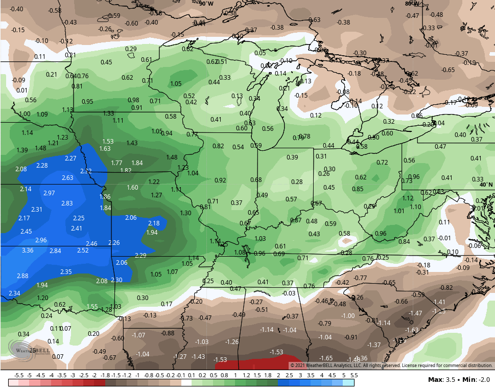
The GFS Ensembles for the next 2 weeks show above normal rainfall…
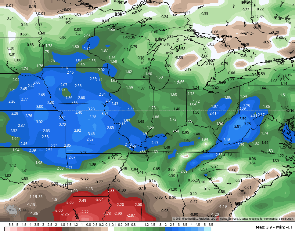
The Extended GFS Ensembles run through June 28th and are even wetter…
Have a great day and take care.

Love the forecast.
Temps. in the 70s for the holiday weekend.
Get out enjoy the great outdoor.
We don’t need that much rain.
The first 90-degree day of the year in the Chicago Metro Area occurred Monday, as highs reached 90 at both O’Hare and Midway Airports. In the SW suburbs at the NWS Forecast Office, it reached 88.
This makes five days in a row of 80+ degree temps. The month is now averaging warmer than normal, with continued drier than normal conditions, and severe drought conditions in far NE Illinois.
Even though we’re in late May, still no organized severe weather has occurred in the Chicago Metro yet this year, and no severe weather watches have been issued. This is the latest into a year that I can remember without any severe weather occurring in at least part of the Chicago area.
We had many days with highs in the mid eighties. Ninety degrees hasn’t occurred yet where I live here in central Kentucky. Maybe today if it doesn’t cloud up.
The return of cooler temperatures will give us a delightful break before the real heat takes hold sometime next month.
Not drought status here, but it is getting close to abnormally dry.
My PWS just south of Bowling Green recorded a high temperature of 92°, the third straight day where the temperature reached 90° or above.