Good Tuesday, everyone. A potent low pressure is slowly wrapping up to our southwest and this will lift northward through the region over the next several days. The end result will be rounds of showers and storms that put down heavy rainfall. This may lead to some local high water issues before the week is over.
I’ve also got some winter talk, so buckle up for a long post.
Today finds a mix of sun and clouds with temps well into the 70s. Scattered showers and storms will go up, but this action starts to increase later tonight. As the low pressure moves across the western Tennessee Valley into the western Ohio Valley Wednesday and Thursday, this sets the stage for some pretty good rains. I have no changes to the overall setup…

The models continue to increase rain amounts as we get closer. The NAM did fairly well with the weekend heavy rain and it’s latching on to the idea of more heavy rains through Thursday night…

You can clearly see how the bands of showers and storms work to the north and northwest. Again, local flooding issues will be possible.
Showers and storms will linger into Friday before ending and giving us a fair looking weekend. Another system may bring rain in here by early next week…

The temperature pattern will continue to skew above normal through next week, but the western part of the country is a different story with some headline making snows possibly showing up at the same time.
I’ve been pointing toward a pattern flip during the second half of the month and most of the seasonal models have been picking up on this well. It’s interesting to note how similar the latest control runs from the EURO Weeklies and GFS Extended are. Check out the banana blocking high in Canada with a mega cutoff in our region…
EURO

GFS

That’s pretty crazy at how similar they are and are only a few days apart from one another in the week or so before Halloween. Have I mentioned the big cutoff low potential for the fall and winter?
On a related note, the EURO Weeklies continue to show early season flake potential into the first few weeks of November…

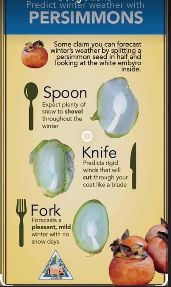
Speaking of snow, if you’re a believer in folklore forecasting…
Not a good sign if you don’t like snow @Kentuckyweather pic.twitter.com/bsJmcW56ZH
— Michael Staton (@mstaton3) October 4, 2021
For those who want a quick rundown of what the heck that even means…
❄⛄
I leave you with your Tuesday storm tracking radars…

Make it a great day and take care.

NAM only showing 0.30” for the Louisville area hope it is correct.
Looks like a good part of Tennessee is in the bullseye for the heaviest rain this week.
Only scattered showers are in my local forecast until the weekend when Summer like weather is forecast to take over with plenty of Sunshine. I wish we could shake this awful weather pattern and get into some great Fall weather. I’m tired of having the air conditioning on to get this high humidity out of the house.
Those maps are beautiful to look at, but isn’t that indicating the same weather we are having now with the upper level low pressure systems ?
Folklore weather forecasting is fun. Every place I’ve live had a Persimmon tree in the yard and back in the 1950’s my Grandmother would always check out the seed to see what the upcoming Winter would bring an announce her forecast at the Thanksgiving table. Good loving memories.
I’m just hoping the heavy rain holds off until later in the day since I’m having all my windows and patio doors replaced today.
Looks like the EURO is picking up on a tropical system off of Cabo.
I’m ready for some more later fall weather, not the early-mid Sept stuff. So far, this fall is tracking warmer than last year, when we had several mornings in the 40s already, and we hit 31 on 10/17.
Gives a whole new meaning to ‘Let’s spoon!’ and with persimmons-pucker up!