Good Friday to one and all. The severe weather threat continues late today through early Saturday across the entire region. This setup is rather potent and is likely to cause some issues across Kentucky and surrounding states.
The Storm Prediction Center is sounding the alarm bells with the Severe Weather Outlook through tonight…

The threat for tornadoes is increased across the western half of the state and the potential is there for a few strong tornadoes. Here’s the current tornado risk map from the SPC…

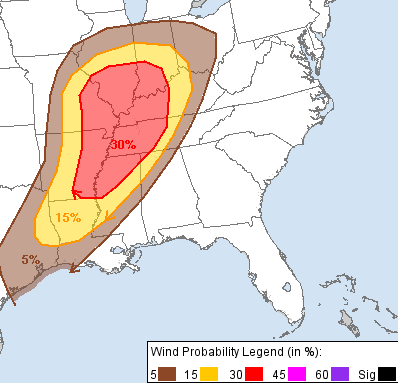
The damaging wind potential is much more widespread across the region and that’s reflected in the latest from the SPC…
While the line should decrease some as it moves into eastern Kentucky Saturday morning, it still can produce severe weather. The Storm Prediction Center has this lower risk area highlighted…

Once again, damaging winds and a tornado or two will be possible.
Temps crash as the storms move away with readings reaching the 30s by late Saturday afternoon.
Seasonably chilly temps will be noted on Sunday before temps surge again next week. Highs are back into the 60s until a cold front moves in later Thursday. That knocks the numbers down and begins to break the pattern down. That pattern breakdown continues into Christmas week with the evolution toward much more of a winter pattern.
I’ve shown the evidence for this switch for a while and now the operational models are going more in that direction. Here’s the latest GFS in the longer range…

That’s NOT for specifics and is to only illustrate the different look to the pattern.
I will have updates later in the day so check back. Until then, here are your storm tracking tools…

Current watches

Possible Watch Areas

Enjoy the rest of the day and take care.

Thanks Chris for the update. I’m concerned more for western Kentucky and southwest Indiana for a possible tornado outbreak. The NWS gives a medium chance of this happening so lets all pray this doesn’t happen !
In my area of south central Kentucky, forecasters are predicting a medium to high chance for damaging straight line winds with the passage of the cold front. Sounds like we may not have power early tomorrow morning ? I have my portable generator ready to respond if this happens, but I won’t have any heat in my home. Maybe a bundle up time in a warm quilt. Stay safe folks !
Thanks Chris, please keep us updated on the severe weather threat.
That’s bad timing to have storms when most people are sleeping.
Just saw a video updating the high potential for severe weather in your area of Western Kentucky. The convective available potential energy is forecast to go over a thousand. Stay safe !
Just issue a tornado watch until 11.00pm apparently the front is moving in my area here Western,ky quicker than thought. Stay safe everyone.