Good evening, folks. It’s a full-blown Winter Storm THREAT for late Friday into early Saturday. A developing storm system will dump snow across the region and there is the increasing likelihood of several inches of snow.
Let’s get straight into it and I’ll spare you the bullet points this go around.
Here’s my very early First Call For Snowfall…
Remember, that is subject to change and it WILL change up until I put out the Final Call For Snowfall on Friday. Still, we are less than 48 hours from this storm impacting the region and confidence is high of a substantial hit for our region.
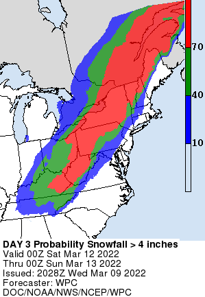
The Weather Prediction Center is also highlighting much of the region with the potential for 4″+ snows Friday night and Saturday…
In terms of the forecast models, some of them are laying a smack down across areas of central and eastern Kentucky.
The new GFS is targeting more of central Kentucky…
Here’s the latest NAM…
The Canadian…
Short Range Canadian…
The EURO…
As you can see, my forecast isn’t going to what some of the models are showing, but I’m taking a conservative approach since we are still a few days out.
Bitterly cold temps come in behind this storm with temps by Sunday morning getting as low as the single digits for some.
Hang tough my springtime friends, temps warm quickly next week and 70 is likely before the week is over.
I will have the latest on WKYT News at 10pm on the CW Lexington and on WKYT-TV at 11. Have a great evening and take care.


If that map holds true as usual western ky will be spre again. The pattern has been so weird this winter, but anyways I’m ready for spring anyhow.
Although I am ready for spring I can deal with hopefully a decent snowfall. All the snow will probably be gone by Monday.
I am looking forward to tomorrow it will be a beautiful day to go outside and enjoy some activities.
*yawn*
WKY misses out…
Surprise
Suprise
Surprise
yet again.
Just come on spring already.