Good Wednesday, everyone. It’s a very active weather day across the Commonwealth with the high winds and the threat for severe thunderstorms. This is ahead of another potent storm system rolling in here for the closing days of March.
Let’s break down what to expect out there today and tonight:
- A Wind Advisory is out for much of the region as non-thunderstorm wind gusts may reach 50mph.
- A line of severe storms moves into western Kentucky this afternoon and early evening.
- The line then moves into central Kentucky during the evening with areas from Interstate 65 to Interstate 75 seeing the storms moving west to east in that 8pm-12am window.
- That line will weaken as it moves east and that weakening will really show up across eastern Kentucky.
- Damaging winds will be likely with this line of storms, especially western and central Kentucky.
- There’s also the chance for a couple of tornadoes to spin up along this line. Those are usually short-lived and the best chance is in the west.
- Colder air comes in behind this for Thursday with some leftover showers around early. Winds are still gusty.
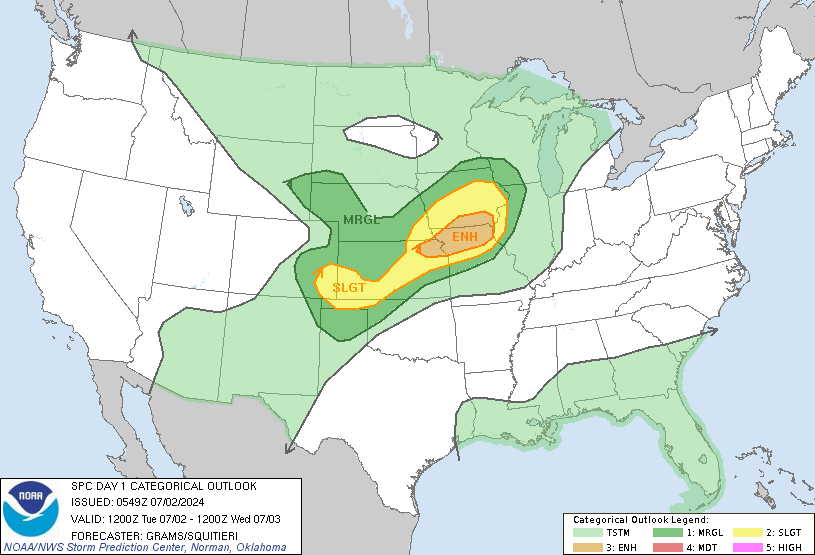
Here’s today’s Severe Weather Outlook from the Storm Prediction Center…

Here’s the overall view showing the greatest risk just to our south and southwest…

That matches up well with the Map I made Saturday…
A few showers will be noted over the weekend with seasonably cool temps. The numbers are likely to come up for the first half of next week ahead of a big storm system. That’s being pushed by another cold shot later next week…
The GFS Ensembles are still insistent on replacing that with a ridge of high pressure a few days later…
I will have updates on Twitter: Follow Me
I will also have the latest on WKYT-TV starting at 4pm and as needed through the night. As usual, I have you all set to track today’s severe weather threat…
Possible Watch Areas
Have a wonderful Wednesday and take care.


Only about 45 days more of madness then it’s warmth and mostly sunshine for a few months! #TeamSpring 🙂
And Humidity.
And High Dew Points……..
I’m Hoping we Receive Rain as we Need it Here in Maple. Only about Two inches Recorded this Month. No Rain in My local Forecast for Today, but Early tomorrow Morning there is A Hundred percent Chance of Storms and Rain Showers. Fingers Crossed on this Forecast. LOL
This has Been the Windiest Month of March I have Ever Experience and also One of the Driest. Wind Gust up to Fifty miles an hour has Prompted a Wind Advisory for my Area Today. UGH !!!
Right now. it’s 74° at my PWS near Bowling Green, and I’ve recorded a 36 mph wind gust. In terms of severe weather, the SPC has Warren County on the border between Slight Risk and Enhanced Risk. The good news is that so far, dewpoints have stayed in the low 50’s. But the Sun has been out since early morning, and as more moisture is injected, the chances for destabilization will increase. However, today’s biggest threat will be straight-line winds. The NAM, Hi-res NAM, and GFS wind estimates are showing gusts in the 65 to 75 mph range. Also. blossoming trees are presenting more surface area, raising the possibility for these winds to bring down large limbs or even whole trees.
My PWS is showing 81 degrees in Perry County with really strong wind gusts. 15% humidity which reminds me of New Mexico or Arizona! Hopefully we’ll be out of the line of fire for severe storms!
Thanks, Chris, as always. Still #teamsnow here.
The temperature in the BG area is 80°, but the humidity has dropped (!) to 36%. Dewpoint is 50°!
This is nuts…