Good Tuesday, everybody. Our big blast of cold air is here and it’s bringing the chance for a few snowflakes to parts of the Commonwealth. If you’re already tired of it, hang tough, things do turn much milder by the weekend.
Our day is starting with some early flurries flying around parts of central and eastern Kentucky. There’s even the chance for a few snow showers to show up. This makes one of the earliest tastes of winter weather on record for the bluegrass state. I have all your flake tracking toys in a bit.
The rest of the day will feature gusty winds with a mix of sun and clouds, and those very cold temps. Highs will generally stay in the 45-50 degree range for many, but those winds will make it feel much colder.
There’s another chance for a rain or snow shower to brush northern and northeastern Kentucky this evening, but most see clearing skies settling in. That allows overnight lows to reach deep into the 20s for many, with some records in jeopardy. The best chance for those records may be across western and central Kentucky where skies clean up much quicker…
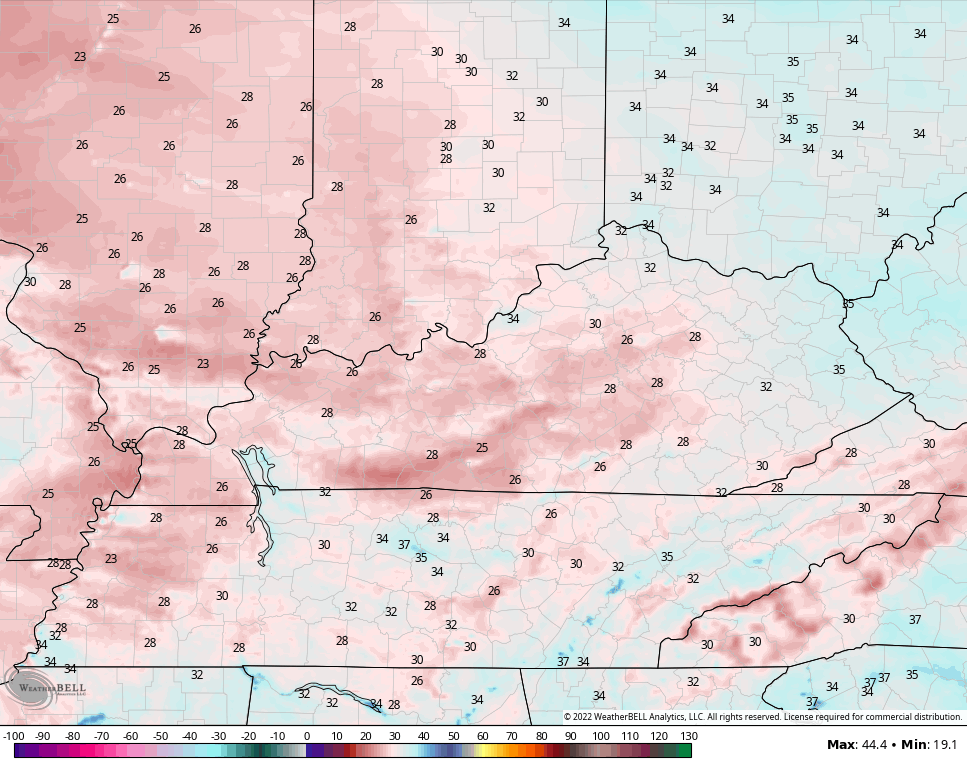
Winds will continue to be gusty and that means wind chills can bottom out in the teens…
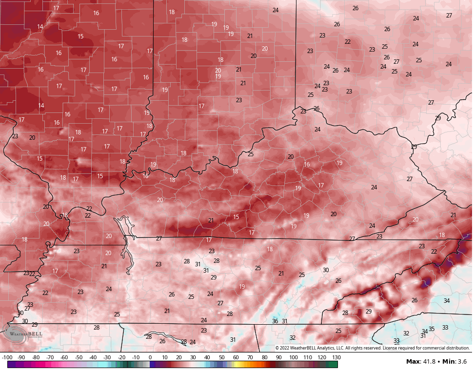
Highs Wednesday are back into the upper 40s to middle 50s from east to west across the state. Wednesday night is another cold one with temps back into the 20s.
We begin our journey out of the winter pattern on Thursday with highs well into the 50s ahead of a much milder push of air on tap for the weekend. Highs are likely to hit 70-75 over the weekend with a strong southwest wind and plenty of sunshine.
Our next system looks to move in with some showers and thunderstorms by Tuesday of next week. At the same time, a system may develop off the southeast coast to further complicate things. The GFS even pops something in the Gulf and gets a little crazy…

That’s way out there in more ways than one, but I do think the pattern can crank a decent trough next week.
Updates will come your way later today and I’ll have the latest on WKYT-TV starting at 4m. I also have you all set with your Tuesday morning flake finders…

LEXINGTON


LOUISVILLE


COVINGTON AREA


FRANKFORT


GEORGETOWN

MOREHEAD


MAYSVILLE

Make it a great day and take care.

Must be exciting for all the young in seeing those first flakes of snow on the radar. To me, I now prefer a milder climate with rains and short lived snow cover to replenish the soils. Not looking forward to those gusty southwest winds and temperatures near eighty degrees over this coming weekend. This can only enhance the Wildfire potential in many areas of the state.
I agree I am more interested in seeing some rainfall.
With no cloud cover last night, my PWS near Bowling Green recorded a low temperature of 30°F, but we’re forecasted to mid to upper 70’s by the weekend, after which temperatures should level off in the upper 60’s to low 70’s range.
Putting together his Winter forecast has to be driving Chris crazy this year, especially in trying to find years sharing similar characteristics to 2022, because in many cases there simply aren’t any! I think the same thing applies when we compare the current La Niña with those in prior years, since the conditions we have long associated with “a normal La Niña Winter” are no longer applicable. Looking at the current Sea Surface Temperature Anomaly chart we see that the body of cooler than normal waters off the west coast of South America are as cool as we’ve seen all year, so what passes for La Niña conditions in 2022 will be maintained at least into early Spring 2023.
In the Northern Pacific, that warmer than normal area is as warm as I can ever recall seeing, but the core of the warm water has shifted farther to the West, near the International Date Line. During the past few Winters, the warmest water was centered in the Gulf of Alaska, stretching over to the Pacific Northwest, which caused the Polar Jet Stream to be displaced northward, and then dove south over Canada, delivering Polar air to the East Coast and the Midwest. If hthe same process applies this year with the west shifted warmer water, then we could see the polar jet stream flow centered on the Midwest and the Great Plains states, along with a possible Polar Vortex intrusion. Further east, a southwesterly flow could set up, dragging warm, moist air from the Gulf. If THAT happens, we could end up with one heck of a Winter!
https://www.ospo.noaa.gov/Products/ocean/sst/anomaly/
This year has got to be driving Chris crazy, especially when he tries to find years having similar characteristics to the current, because in many cases, there aren’t any! I think the same thing applies when we compare the current La Niña with those in past years, since the weather we associate with a “normal La Niña Winter” is no longer applicable. Looking at the current Sea Surface Temperature Anomaly chart, we see that the body of cooler than normal ocean waters off the coast of South America is are cooler ever, so La Niña conditions (the 2022 version!) aren’t going anywhere.