Good Wednesday, folks. Our historic early season blast of winter weather continues across the region, but big changes are brewing for the weekend. That’s when temps get set to take off, just in time to enjoy the peak of those fall colors.
Before we look ahead, let’s quickly review the historic nature of this early taste of winter.
- Central and eastern Kentucky had one of the top 5 earliest snowfalls on record.
- A few spots even had the ground covered for a short time.
- Record cold high temps were also observed
- Record lows may fall this morning then again Thursday morning.
Are there any clues this historic cold and snow can give us about the winter ahead? Let’s focus on just the snow part of this and I’ll sure Lexington as the example.
Here are the top 5 earliest snowfalls on record:
October 6, 1952 – Trace
October 10, 1906- Trace
October 11, 1905- Trace
October 18, 2022 and 1989- Trace
October 19, 1917- 0.2″
As you can see, yesterday’s trace of snow tied 1989 for the 4th earliest snowfall on record. It also tied the record cold high temp from at 47 degrees from the same day in 1989, so let’s start there.
The winter of 1989/90 was one of the wildest on record. December 1989 was the coldest ever recorded with 6 days going below zero. We also had almost 10″ of snow. Once we hit January, winter was done and it essentially didn’t snow again. Temps flipped to much warmer than normal for January and February. Wild, huh?
The winter of 1917/18 is legendary and one of the worst winters on record. It was the 2nd coldest on record and was the snowiest on record. December was the 3rd coldest ever and was the snowiest ever with almost 20″. January was the 2nd coldest ever and was also the snowiest ever with 23″ of snow. The Ohio River froze over this winter, folks.
The winter of 1905/06 featured slightly colder than normal temps and above normal snowfall with a little more than 25″. December was colder than normal with 7″ of snow. January featured above normal temps with 5″ of snow. February turned frigid with a little more than 10″ of snow.
The winter of 1906/07 featured near normal temps with more than 27″ of snow (above normal). December was colder than normal with almost 4″ of snow. January had 9″ of snow with much above normal temps. February turned frigid with around 9″ of snow.
The winter of 1952/53 is the lone winter that didn’t have memorable winter weather. Temps averaged above normal with slightly below normal snowfall.
So we have 4 of the 5 featuring memorable winter weather periods for the following winters, with one of those being the worst on record. December’s also stand out as having some severe cold shots and above normal snowfall.
Oh, and all 5 Novembers were colder than normal and 4 of the 5 featured accumulating snows.
That’s still a fairly limited sample size to pull from, but it’s always fun to look at things like that.
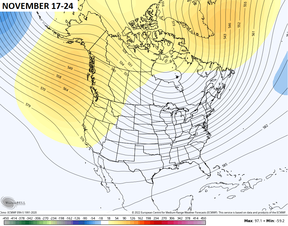
I have been arguing for an early start to winter and the EURO Weeklies are also on my side at the moment. Check out how they have the deepening trough getting established in our region before Thanksgiving…
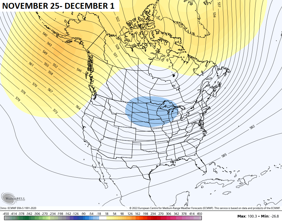
Watch how it closed out the month and kicks off December…
As we get back to the weather of the near term… Temps climb this weekend with highs in the 70s on a gusty southwest wind. The forest fire risk will be way up this weekend, folks!
Changes show up the first half of next week as a storm system rolls through here with our next chance for rain. How this unfolds is still a work in progress on the models…

Have a wonderful Wednesday and take care.

Hey Chris – I don’t know about analogs anymore…. nothing is normal now..
I wasn’t living here in 1989 and although I would take a cold/snowy December…the fact that there was basically ONE month of winter (albeit brutal) only for it to end for the rest of the winter? Not sure I’d be loving that….I think I’d rather Dec be warm and Jan/Feb/March be cold/snowy….But that’s just me rambling. It’s gonna do what it’s gonna do.
Totally agree. A warm second half of winter not only feels weird, but plants seem to think it’s time to go & grow – only to get a rude surprise when late season cold spells crush them.
We seem to almost always have those late Spring freezes. My last one was in 1974 when I lost countless number of Azalea plants. I was totally out of nursery business for two years.
Surprise Chris you failed to mention 1976-77 Winter and 1977-78 Winter which were very memorable as far as record cold and many snowstorms plus my first major blizzard in January 1978. Winter Lover is the only commentator on the blog that has acknowledge these very severe Winters. Are we too old now ?
Schroder, those winters were very brutal not only all what you mention plus the Ohio river froze over too. I was in my teenage at the time never will forget it.
I think most commentator that goes on here weren’t born at the time what transpire back in the mid to late 70’s
I feel old now and I turn a year older in November. I have a lot of memories of many Winters of the past. We never were excused from school because of a 4 to 6 inch snowfall. I enjoyed going to school when it snowed as we had fun at recess with making snowmen and of course many snowball fights.
1969-70 was also a very snowy Winter that lasted from December through the month of March with no Spring freezes. A beautiful White Christmas and New Years day to boot. Looking back 1962-63 was another severe Winter that maintained a snow pack almost all Winter. With temperatures well below zero. Since the year 1978 the Winters have changed to only lasting about 2 weeks. Blame it on ENSO phases the PDO and all the other teleconnections.
The amount of area this current cold air mass encompasses is very impressive! I was just looking at a current temperature map of the US at 12:30 PM EDT, and it’s only in the 50s as far south as the Gulf of Mexico and most of Florida. You have to go all the way down to Miami to see temps in the 60s. Frost advisories are in effect for Northern FL tonight (and it’s only mid-October).
East of the Mississippi River, the only other city that is over 60 degrees as of 12 PM is Caribou, Maine at 62 degrees. Caribou is in far Northern Maine and is usually one of the coldest places in the country this time of year. The cold air hasn’t advanced that far east yet.
I just hope we have at least one good snow. Thanks Chris for all your work.
I just wish we would enter a very rainy or snowy pattern. This current pattern has wore out it’s welcome BIG TIME !!!