Good Friday to one and all. Changes are showing up out there today as scattered showers and thunderstorms roll in from the south. This is ahead of a of a much bigger system rolling in here Saturday night and Sunday. That brings storms and much colder winds behind it.
Temps today are in the 70s across Kentucky with clouds spinning through here. Those clouds are from that low coming out of the deep south that will also bring some scattered showers and thunderstorms with it. The greatest threat for these today will be across central and eastern Kentucky, but this is NOT all day stuff.
Here are your radars to follow along…
That pulls away later tonight, leaving us with just a small shower or storm chance on Saturday. Highs reach 75-80 degrees for most of the state, making for another winner of a weather day.
A potent low pressure works from the Plains toward the Great Lakes Saturday into Sunday. That drags a strong cold front across the state into Sunday with showers and storms along and ahead of this front.
This looks a little slower for the arrival time and that may keep the greatest risk for severe weather to the west of Kentucky on Saturday. Here’s the Saturday Severe Weather Outlook from the Storm Prediction Center…

With a slower arriving front, we will need to see if we can fire off some stronger storms for Sunday across the eastern half of the state. Here’s the Sunday Severe Weather Outlook from the Storm Prediction Center…

Cold winds crash in quickly behind this system with chilly showers into Monday for the central and east. Wind chill temps on the GFS look ugly…
This same system may produce flakes just to the north of the Ohio River…
What the what is that? 😡
Temps do warm quickly by the middle of the week with 80 degrees possible before the week is over. That will be ahead of what may be a strong to severe storm maker late week or next weekend.
The various Ensembles continue to advertise a colder than normal pattern into the final week of April. Check out this ugly setup…
Where was that during the winter?
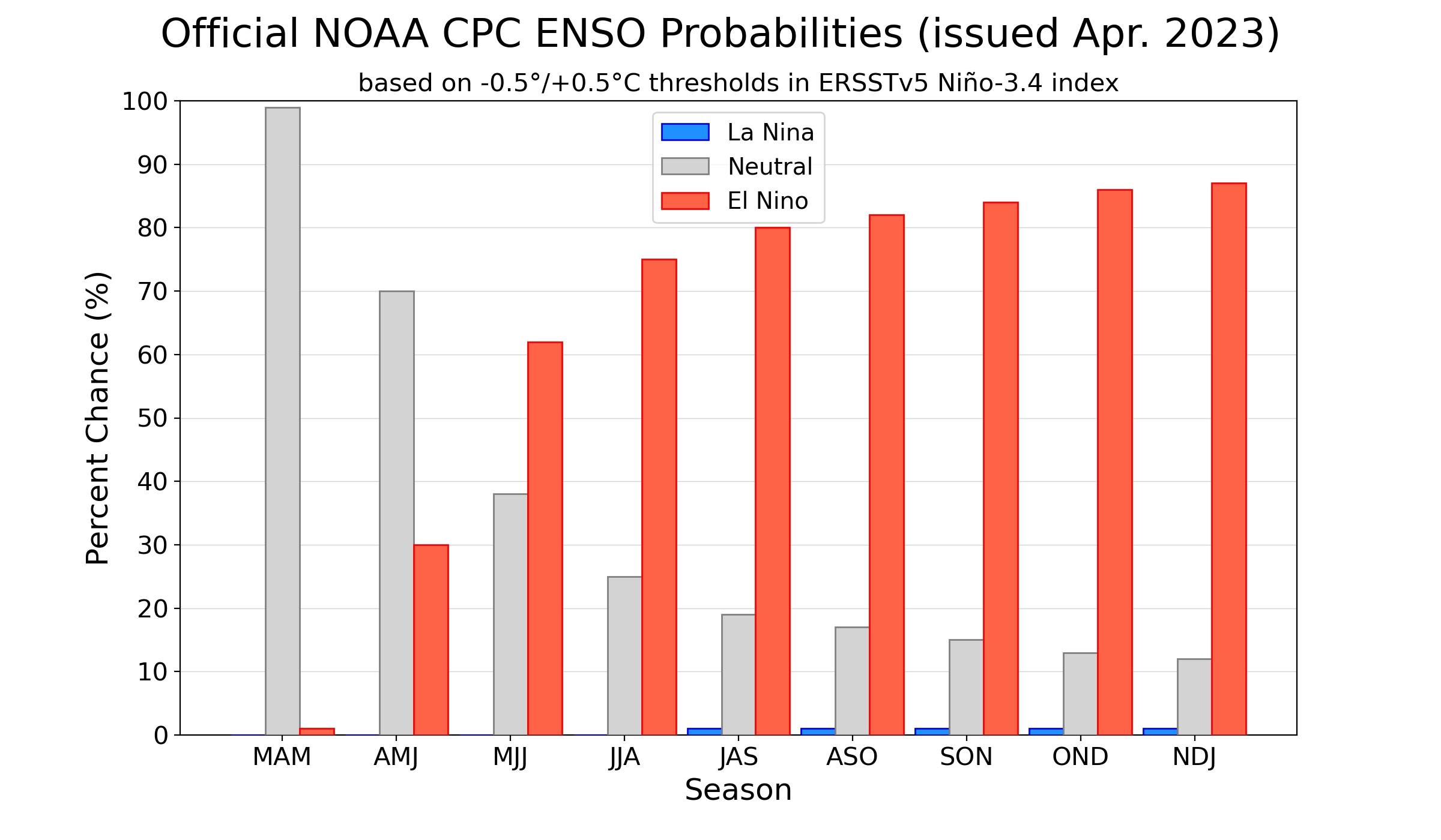
For a while now, I’ve been talking about how we are coming out of a three year La Nina and going into an El Nino and I have no changes to that thought. NOAA is out with their latest ENSO probabilities, and you can clearly see how likely this thing is…

With trade winds expected to decrease along the equatorial Pacific, this El Nino may really take off this summer. A moderate to strong El Nino is possible by fall and winter.
Enjoy your Friday and take care.

The ensembles have been waffling so I’ll just believe it when it happens.
Looks like the thermostat is going to be hotter than normal this summer.
Thanks Chris. Really nice and pleasant weather this past week, but we could use a period of ‘ April Showers ‘ to bring the growing season into full swing. The cool nights and low relative humidity and dewpoints has been slowing down foliage maturity in my area.
The low pressure system to our South has a very interesting look to it. Hopefully, we will receive some much needed showers from the system. Below normal temperatures ( model forecast ) is the reaction to having such a mild Winter.
Glad to see that the Pacific may be turning positive and the Atlantic negative. Next Fall and Winter will be interesting. About time we have that change.
I thought Cali got their good rains during EL NINO years….You know, like they had the past few months…
Glad to see you back posting Mark. Been wondering where you were. I then thought you went home for Easter in North Carolina ?
California in the past El Nino years was pounded by severe storms and flooding rains. I don’t think it makes any difference what phase ENSO is in for what weather type they may receive on the West Coast.