Good Saturday, everybody. It’s a busy weather day across Kentucky with rounds of showers and thunderstorms with the chance for strong to severe storms also showing up. This will be followed by a temp crash and the chance for some snowflakes to show up on Sunday.
Let’s get to the breakdown of the day:
- Scattered showers and thunderstorms will rumble across the state early today.
- The prime time for severe weather is roughly 3pm-10pm with the progression from west to east.
- A line of strong to severe storms develops west of Interstate 65 and then rolls eastward.
- The greatest risk for severe storms looks to be south of Interstate 64 and between Interstate 65 and Interstate 75.
- Damaging wind is the main threat, but a few storms may be spinning so I can’t rule out a tornado or two.
- Storms should weaken into the east late this evening.
Here’s Today’s Severe Weather Outlook from the Storm Prediction Center…

Here’s a breakdown of the individual threats we’re facing today…
Damaging Winds

Lare Hail

Tornadoes

This animation of the HRRR future radar goes from 1pm through 11pm…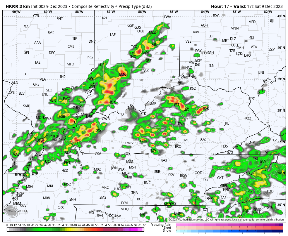
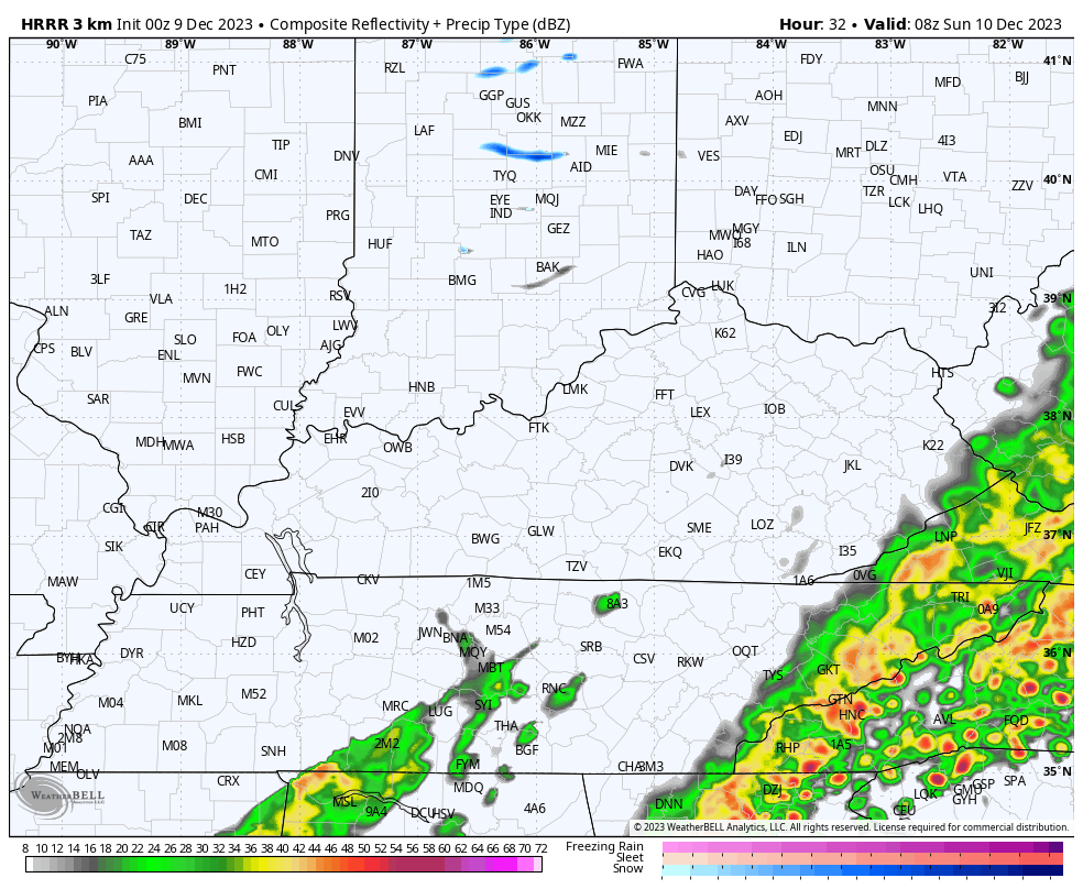
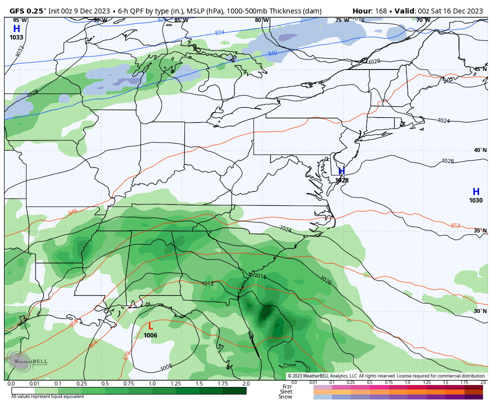
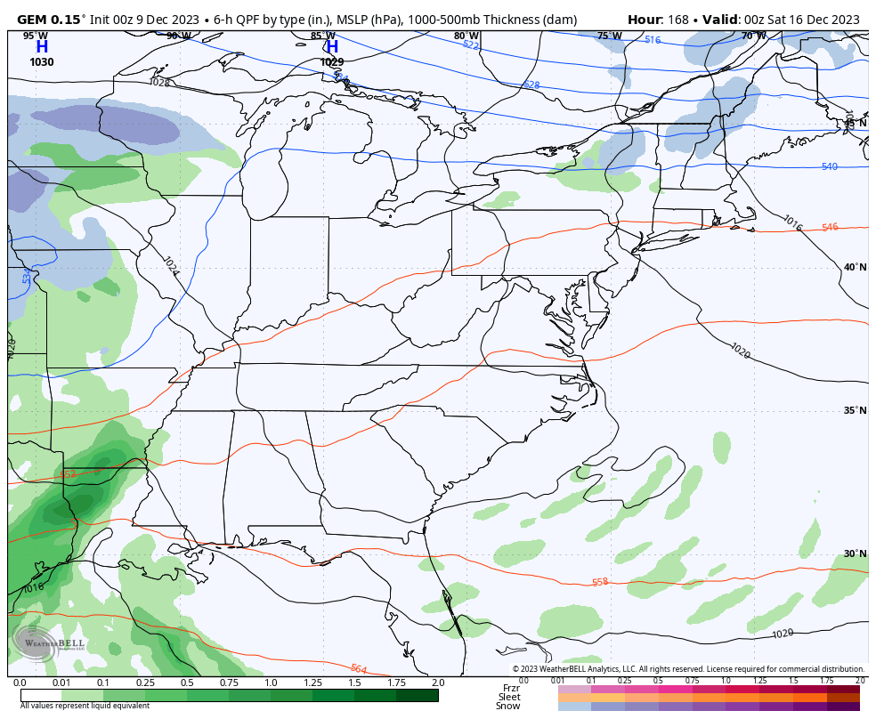
The low pressure developing along this front brings more rain to the eastern half of the state tonight with a switch to some wet snow on the western edge of this. The best chance for this to happen is across the southeastern part of the state.
For the rest of the region, a northwest wind will try to spit out some flakes from time to time from Sunday afternoon through early Monday morning. The latest future radar from the HRRR continues to be the most optimistic with these flakes…
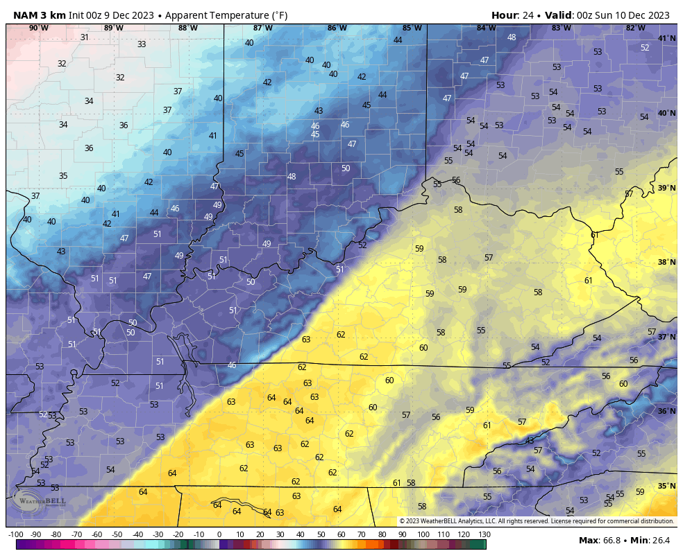
Sunday is a cold day with temps falling into the 30s behind the front. Gusty northwest winds will make it feel much colder. Check out the wind chill forecast from 7pm this evening through 11pm Sunday…
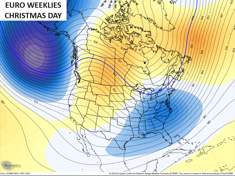
Monday is another seasonably cold day before temps moderate to normal from Tuesday through Thursday as the weather goes calm for a bit. That doesn’t look to last into next weekend as the signal for a big eastern US storm system continues to grow. The models are trying to get more interaction now between northern branch and the system coming out of the south…
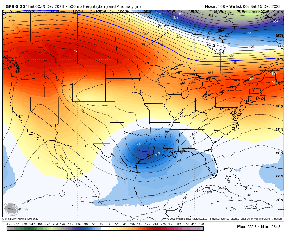
The surface reflection continues to suggest this big storm system somewhere in the east…
GFS
CANADIAN
This seems to be lining up with the time period the MJO starts to emerge out of the warmer phases and go toward the colder phases for the second half of December.
Speaking of, the EURO Weeklies continue to give us a good look for Christmas Day…
The Control Run does too…
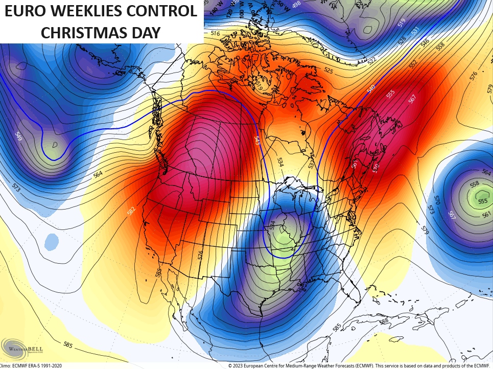
Interesting.
I will have additional updates later today. As usual, I have you all set to track today’s strong to severe storms potential…

Current watches

Possible Watch Areas

Have a great Saturday and take care.

Well after 2 days I was able to log in. I almost gave up.
I’m not upset with this winter so far at all…. Look at it this way… If we have a brutal cold/snowy December… odds are that will be it for winter… Hasn’t that happened several times? I know 1989 and a couple of others years Dec was terribly cold and snowy…but then after that, the rest of the winter was BORING…It seems like if winter holds off at least until late dec, the odds of it being a good winter for snow/cold are better…. But this isn’t scientific at all obviously. Anything can happen. I think the winter of 76 and 77 didn’t start until after New Years…I remember someone on the blog talking about how that winter was boring up until New Years then we got blasted for the rest of the winter.
Mark, it was 77-78 winter that was boring until New years. We had that blizzard that occured in January and one snow fall after another miss over month straight of school. Temps never got over the freezing mark from Jan to March. I was a teenager at the time never will forget it. To add more note the winters 77, 78,79 was a string extreme winters when comes to cold and snow. Even the mighty Ohio river froze over in one of those winter. That’s how cold it was
Right Mark, When I was living in Indiana in 2004, we had 2 feet of Snow on the ground with below zero temperatures on Christmas morning. The rest of the Winter 2005 was Snowless and boring.
There was a minor ice event in central Kentucky too.
There was a MAJOR Ice Event in Kentucky in 2008- 09 that did 10,000 dollars worth of damage to my property. No power for almost a month. Nearly froze to death.
I certainly remember that like we all do. My power was only out for four days thankfully.
Thanks Chris, Hoping we receive some Rain out of this system, as our soil moisture is still way down. Does anyone else notice that this weather pattern just keeps repeating year after year ? I like the temperatures, but not the drought we are in. I read that the Pacific Decadal Oscillation will remain in the negative phase until 2030, so there is no point in discussing this any longer.
Not agreeing with any weather models and predictions for a Colder and Snowier Winter. I just don’t see it happening, especially in my area of Kentucky.
I’m concerned about the chances for severe weather in South Central Kentucky late this afternoon. We will definitely be in the system’s warm sector, with higher dewpoints and increased instability, and the most recent HRRR run is hinting at the possibility of supercell formation in the region. In addition, the latest forecast shows the jet stream oriented over Western KY, so there will be abundant shear. The setup is eerily similar to mid-December, (almost to the day) just a few short years ago!
I’m concerned to Joe. In 2020 when we had that Tornado outbreak in Western Kentucky, a Tornado touchdown in Taylor county about 1/2 mile from my home that early Saturday morning. The j/kg is forecast to go to 300 this afternoon. It looks now there may be Sunshine later this afternoon. Not good. No Rain has fallen in my area and I don’t expect much out of this system and another dry week is ahead. Forecaster’s just keep ” kicking the can down the road. “
There’s a Tornado Watch in effect for all of South Central Kentucky, including Warren County and the Bowling Green area. The watch is in effect until 7:00pm CST.
Strong to severe thunderstorms will continue to develop and increase through early afternoon near an eastward-moving cold front, with additional/more isolated development also possible ahead of it later this afternoon. Increasingly low-level moisture and strong shear will support the potential for severe storms including a few tornadoes.
If we go by recent winter trends, it does not look super good for this winter for snow. Especially last winter, that was a record or near it for low snow totals for most of KY. When some YouTubers were touting 20% more snowfall than normal for this winter, that does not even get us in double digits using the last few years as “normal”.
I’m fine with not much snow, just as long as no big ice or super cold….. Or no big wind events….. All stuff we got instead of snow for the last few years… Another thing not good from a recent trend standpoint.
The resident contrarian returns!
I don’t like ANY weather event that takes out the power. My prefered temperatures for Winter would be 40 to 50 for a high and 20 to 30 for a low. NO Ice and a few 4 to 8 ” Snows. This Winter I would like to see several good, soaking Rains, but I don’t think that is going to happen.
It’s been a very mild first eight days of December here in the Chicago Metro Area, with temperatures averaging almost seven degrees per day above normal, and only 0.3 inches of snow so far for the month. That’s very typical of an El Nino Winter in the Midwest.
Several days ago, a couple of the computer models indicated a significant snow area in or near Chicago for Sunday, but that’s not going to happen anywhere close to here. That continues to show the unreliability of long-range precipitation forecasts more than a few days out, especially in the Winter.
I am skeptical of predictions of below-normal temps for the second half of December, but it was last December when that brutal cold wave hit for several days before Christmas with wind chills here of -35. We’ll see how things play out.
Currently we are receiving our Cold air from the North Pacific and not the Arctic region. I’ve read very little on the Polar Low or the Polar Vortex. I did read that the Polar Low will undergo Sudden Stratospheric Warming like it did in that very frigid period last Christmas. It just amazes me that we have not undergone any changes in the precipitation and temperature patterns. Both remain weak and inactive for several years now. Has to be that seldom discussed PDO in the negative phase. ENSO is present only at the surface, just not reacting to our Atmosphere to change the Jet stream. In 2014-15 ENSO the PDO went strongly positive in 2014, and resulted in a very Cold and Snowy Winter.
Schroeder hope your ok heard tornado touch down in your county. Take care
I’m OK. We didn’t receive anything but a few bouts of Rain / showers here in Maple. Thanks for caring Winter Lover.
Wow it’s been close to 70 here I think last temperature I got when I checked was 68 I just heard from a reliable weather person that there was a tornado near or close to Bowling green area and something about Tennessee boarder and in TN has anyone heard that????? Are there a Bowling Green Tennessee???? I guess we all should be weather aware as Chris has been telling us. It just bothers me in the east we didn’t usually get our severe weather till after dark after it works across the state stay safe everyone.
Guys that good of been Tennessee they were talking about not sure
A Tornado touchdown in Clarksville, Tn. I saw on the news that there was a lot of damage in certain areas of the City. I pray and hope there wasn’t any lost of life or serious injuries to the residence of the City.