Good Wednesday, everyone. Another extreme weather pattern is taking shape across our region starting today and running through the weekend. A tornado outbreak is possible later today into tonight for parts of Kentucky and surrounding areas. This kicks off an extended period of severe weather with flooding rains.
Here’s a fresh breakdown:
TODAY
- Gusty southwest winds may have gusts in the 40mph to 50mph range at times.
- Temps surge into the upper 70s and low 80s.
- Isolated showers and storms will be possible.
- Strong to severe storms develop just west of the Ohio and Mississippi Rivers this afternoon and then roll east.
TONIGHT
- Severe thunderstorms blow up across western Kentucky early this evening.
- Tornadoes are likely to develop with the possibility of a few long-tracked, violent tornadoes.
- The greatest tornado risk is across the western half of the state.
- Severe storms become more linear by late evening as they move toward Central Kentucky.
- Damaging winds and a lower tornado threat will still be noted.
- This line of storms will be oriented from southwest to northeast through the state and may not make it into the southeast.
- Torrential rains are likely with these storms, with local flash flooding developing.
THURSDAY
- Waves of strong to severe storms continue to develop and roll from southeast to northeast across the state.
- Damaging winds and a low-end tornado risk continue to be noted.
- Torrential rains will also continue with the flash flood and general flood threat increasing.
- Some areas may pick up 2″-5″ of rain on the day.
- Once again, the southeast sees the least amount of action.
FRIDAY
- The day starts with widespread showers and storms.
- Once again, severe storms with damaging winds will be possible.
- There’s still a low-end tornado risk.
- The focus of the storms should gradually shift northwest through the day.
- This means the greatest threat for flooding Friday into Friday night focuses on western Kentucky into the northern part of the state.
SATURDAY
- Widespread flooding is likely across areas of western, central and northern parts of the state.
- Strong to severe thunderstorms should focus across the west and north through the early afternoon.
- A large chunk of central and eastern Kentucky may spike into the 80s with some sun, making for a very unstable atmosphere.
- The severe storms risk then focuses across the rest of Kentucky later in the afternoon and evening.
- Damaging winds and a few tornadoes will be possible.
SUNDAY
- Widespread flooding may be ongoing to start the day.
- Heavy rain and thunderstorms across central and eastern Kentucky start to slow down.
- Gusty showers will be leftover in the afternoon as colder winds kick in.
Here’s a general look at the area at greatest risk for significant to major flooding issues through Sunday…
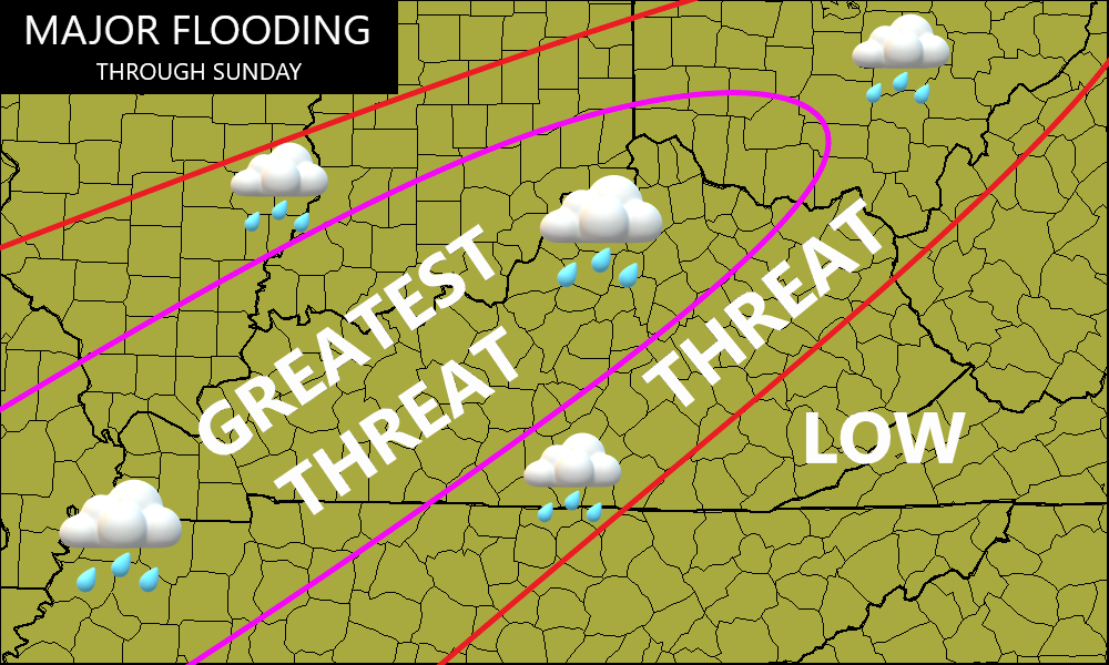
We may very well see a VERY sharp cutoff to the heaviest rains across eastern and southeastern Kentucky. As a matter of fact, many in the far southeast may not see much rain until Saturday night.
The Storm Prediction Center now has a rare HIGH Risk for severe weather across western Kentucky with a much lower threat into eastern Kentucky…

A few tornadoes are likely later today in western Kentucky. Here’s the Tornado Outlook from the SPC…

The Damaging Wind Threat continues to be the top severe weather risk…

Large hail is also a big player in the west, with a lower threat across central and eastern Kentucky…

The severe threat for Thursday looks like this…

That threat continues into Friday…

The threat for severe storms then rolls into Saturday and Saturday night.
I’ll have updates later today and will likely be on WKYT-TV as the severe weather is blowing in. Until then, here are your Sunday severe storms tracking tools…

Current watches

Possible Watch Areas

Make it a great Wednesday and take care.
