Good Tuesday to one and all. Kentucky continues to be under the influence of a brutally cold air mass today. It’s one that may produce record lows to start the day. The good news is that thermometers start to warm up over the next several days. The bad news for mild weather fans… it’s not going to last very long.
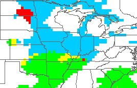
Let’s start with today and roll ahead. Lows this morning should range from 0 to -10 and some records may fall. Track it all courtesy of the good folks at the Kentucky Mesonet…
Today’s Lows

Current Temperatures

Wind chill readings from -20 to -25 to begin the day and will head closer to 0 later in the afternoon. That’s when high temperatures warm into the upper single digits to low teens.
Wednesday will see the barbaric cold give way to a more seasonal brand of cold with upper 20s to low 30s. Clouds will increase later in the day and we will see the possibility of a touch of light snow by Thursday…
That’s on the nose of some milder air that moves in for Friday and Saturday. Temps should warm into the 40s as our pattern becomes rather unsettled. This should mean some rain over the weekend and any warm up that starts with rain is usually one that’s short lived.
The models are trying their best to crank a bigger storm system by Saturday and Sunday…
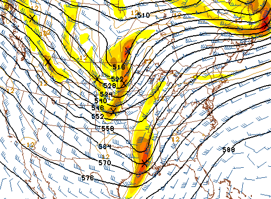
There isn’t a ton of cold available by that time, but it will be worth watching to see if we can phase the streams.
From there… watch how the upper level pattern reverts back to a deep trough in the east… 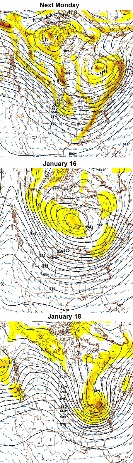
The GFS Ensembles are all over this, too…
What does that mean? A lot of cold and many snow chances are ahead of us for the second half of January and into February. I don’t think we are done with the extreme events and I have NO doubt the biggest snows are still ahead of us.
Make it a great Tuesday and take care.

Thanks CB!
I’m depressed over the Auburn loss. With regards to the future of snow in central ky I’m equally depressed. No disrespect Chris but DeJa Vu.
True dat. CB rocks, but our snow likeliness sucks. Many years and this winter so far for the usual suspect areas is about zip for anything above a few inches. Seeing several ankle biter chances but that is it.
With the lake freezing where we get our clipper action from- TREND says BEND to the knees and hail it’s mighty powah’!
an ankle biter would quadruple the snow total I have had this year
Amen here too!
Lakes not frozen yet. Still lake effect snows going on in NY….1-2 1-4 inch an hour going on there.
2 Plus feet of snow off Lake Onterio through tommorow….Road Trip anyone…
In regards to CB’s retweet of Jennifer Palumbo, there’s actually a really large “campus” right by the New Circle Road / Richmond Road interchange that would have made for a “mega” helpful temporary shelter for this brutal cold weather situation. And yes kids, it is fully functional right now.
For right now, instead of leaving those people outside, just take them across the street to the Waffle House. The late night manager at that location is very nice, as are some of the regular customers, and I have no doubt would help out.
CB, given that you feel we have some just as bad or worse situations in the near future, please make your expertise known to Mayor Gray in the hopes of pushing for additional measures before we’re in this again.
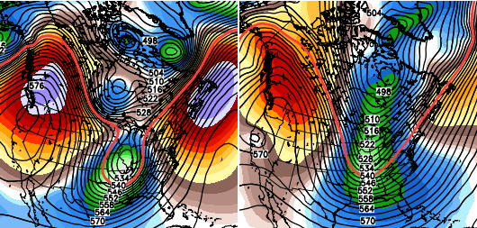
Also, the left half of the GFS ensemble looks like an angry owl. Ugh, I need to sleep.
That is one mean looking owl!
Who?
Is going to be the Cards next coach?
Did lex ever hit -5 tonight? Guess we won’t go below the -6 of 2004 or the -7 of 2003.
I think -4 will go down as the official low. I had -7 in Lawrenceburg as a low, which is also the current temp here.
As I suspected, mesonet low was 2 degrees colder than BGA low, which is sort of opposite to normal because BGA was the colder of the two in the past…It makes you wonder, had this cold snap happened a few years ago, before whatever happened to the BGA thermometer, it very well could have been a tie or record.. Either way, not a record, which is hard to believe as extremely cold as this was.
Needed more snow pack to get to those numbers it would seem. We got more of a snow packaging (thin layer).
Thanks Chris. Everyone stay safe in the cold today. Excuse me now while I go get into enough layers to dress two people to go to work.
I predict “the doubters” will have fun with your prediction of the “biggest snows being ahead of us” today. As long as it’s not a “wall of snow,” I give it a 50/50 chance. Thanks for all you do, Mr. Bailey!
Most of the Doubters on here are very big snow lovers who follow the trends of Ky Snows. Until the trends over the past 15-20 years change I doupt we will have a big snow over the 2-4 that our area usually receives. I am in Lou. and I am sure BubbaG, MarkLx, Chris Mercer, Andy Rose and others would agree. Unless it is a freak storm Ky will get Ankle Biters. Not getting to excited by any model that comes out in the future. This last storm was the last one I get excited about 3 days out. Ky snows stink…..But I will still THINK SNOW!!!
“biggest snows being ahead of us”…..well, 1″ is all it will take here at my house to be the biggest snow of the year, so, no excitement here over that statement. Bring Spring!!!!!
I hear ya, about a 1.5in. snow is all it would take in my area of Frankfort?
hey all you weather buffs out there i need some help and possibly some research about the polar vortex…….is the vortex a common occurrence or is it a thing that happens 1 time out of so many years…..seems a met from the huntington, wva area posted on fb that this was an occurrence that happens all the time in our neck of the woods……this met got his info from the nws in newyork city……while it may be a frequent deal up there, i say this is mostly false info……this is not about who is right or wrong but giving the facts to the public…..thank you guys and gals for any help.
doesn’t the blocking cause it? causes the jet stream to dip thus bringing a piece of it off and bringing it south…..
What I have read is that the the Polar Votex is the upper layers of the Stratosphere in which are very very cold. When you have warming of the upper Stratosphere the cold air has no where to go but down as cold air falls correct. If we have blocking in place the Jet stream heads south bringing the cold air with it. This happened a couple times last year but the extream cold dropped in Europe instead of the US.
Could be wrong but 2 winter’s ago the Vortex was sitting out in the pacific..Remember when part’s of Alaska was buried with cold and snow while we Blow torched..The cold is on our side of the globe this winter with a favorable Pacific.. If we could get some blocking to go with it systems will not go north to the lakes..
Minus 2 here.
I see the GFS has the rain snow line near the Kentucky and Tennessee border. by Thursday that line will Be on the Kentucky and Indiana border.
wwitwb…..You are absolutly correct
-3 in London currently. Whatever we may or may not have looming in the future, a brief warm up would be ok with me. If I may put in my order for next week, a general 8-12 inches of snow across the whole area, with temps staying in the teens for a few days. Positive numbers are nice.
I for one hate this weather; i’m so ready for spring, forget these days like this!! has anybody read the farmer’s almanac ? did it predict this bitter cold ?? curious
I believe The Farmer’s Almanac called for snow and biting cold this winter. The biting cold part is really panning out it seems.
our low here at my house was 5 below last night! Why is there always a “hole” over the Greenup/Boyd area on the kymesonet temp map above? It would be nice to see what our temps/winds are on that map. thanks Chris for all you do to keep us up to date on the weather!!!!!!!
Someone must be holding a lighter under the Hart Co. thermometer. Mesonet shows 18.
Considering the biggest snow at my house in Knox co. has been about one inch I guess the “biggest snows are yet to come” comment has a good chance of coming true. Lol
I know the feeling, except the fact it would only take about 8 tenths of an inch to be the biggest here. That may just happen over the next couple months!.
My thought too. Not hard to hard for more with almost nothing so far.
Wondering if my igloo comes with a lifetime guarantee. 🙂
Well If you want to be technical, according to one poster, Lexington did have thunder snow when the front blew through here with the heavy snow. I wonder what made the system sort of intensify just as it got past Frankfort? And it was very heavy, and I don’t doubt that there was thunder. If that snow had lasted just 3 hours at that rate, we could have had 4 to 5 inches at least.
I just heard a “coming up the next hour” on tv that a town in TN’s water supply froze? That made me wonder what keeps ours from freezing? I guess by code the pipes have to be buried so many feet due to climate? I dunno
..
My hot water pipes froze at my house but my cold pipes did not got no hot water but have cold water I even let the water trickle last night and hot water pipe still froze. 🙁
we had 5 below in town – 7 below out in county.
looking forward to some more snow chances after the thaw!
thanks, Chris!
Dodger says in past cold winters the storm track often sank further south and the lower Ohio Valley typically got at least one good snow by early March after missing Jan chances to the north. Guess we’ll see. Dodger
A lot of naysayers on here forget that several of the big snows they remember happened in March or April. The “storm of the century” happened in March of 1993. The deepest snow I have ever seen, 36 inches, happened the first week of April, 1987. So don’t give up the sled until summer, notice I didn’t say ship:)
Where are all the naysayers that said it couldn’t get below freezing without a deep snowpack?
You mean below zero?
Yep, definitely meant below zero.
There were 4-5 different posters who said that from what I remember. Several of us know who they are. lol
I remember only 1 saying that and it was ME . I’m not hiding as you can see I posted earlier today then I had to plow through all the salt on the roads to get to the Grocery store
When will the warm up occur? I never understand the weather sites like crackuweather, lol. If the high today is 10 degrees and the low tomorrow is 22 then does that mean at midnight it will suddenly be 22 degrees?
Just wondering if tomorrow morning is still going to be bitterly cold before the warm up begins or if we can expect somewhat of a warmup overnight?
First and foremost, never, ever, listen to anything “crackuweather” has to say. Second, that is a very good question which I cannot answer unless they are breaking the 24 hour period into day and night. I have seen the same situation concerning temps on several different sites.
if it is so bad, then why is there a link to it on this blog ?? hmmmmmm your boy chris has the same situation also … back at Christmas he said ALL of January would be a arctic zone …. well i’m not a genius by no means, but today is the 7th and we’ve had at least 3 days with temps in 40s and 50’s, and according to WKYT the next 8 days starting Thu are going to be 45 degrees and higher …. so doing the math, that is 11 days out of 15 where the temp is higher than 40 …. so where is the arctic zone ???
Ummm, yeah, I challenge you to go back and find where CB said that every day in January would be an arctic zone. You cant, because he never said that. Just as you said yesterday that Accuweather called the arctic outbreak 2 weeks out….they didn’t, and it was long after Chris said it would happen before they even mentioned it was possible. Quit making things up as you go….which is obviously what you do.
ummmm yea … Dec 26 post, here is a copy/paste of the exact words …
“You will have plenty of cold and snow chances coming next week and for most of January. This is also a pattern that can deliver the elusive “big one”. Practice up on those snow dances… you will be getting your groove on a lot in the coming weeks”
so troy, no apologies needed – I don’t make things up …. you’re a big boy, go back and read it – it is in the archives
I see nothing in that post about “ALL” or “everyday” of January. Sorry, try again….
na
you can’t change stupid !!
First, in what you quoted it said no where that all or everyday would be “arctic”. Second, if you think CB is such a bad meteorologist, why do you come here? Why don’t you just stick to accuweather if you think it’s so great? Oh, that’s right, there is nowhere to troll on accuweather!
lol. She already answered your question Big Papa……answer:you acn’t change stupid!
I’ve
never
ever
said
chris
was a
bad met,
just
stating facts
hmmmmmm your boy chris has the same situation also … back at Christmas he said ALL of January would be a arctic zone this is not a fact
I would welcome any ankel biters to come, since that would be a upgrade in my area from 5 toes biters and deck dusters 😉
*ankle
A little childish to correct someone else’s misspelled words. Is it not?
Thanks, spell check police are everywhere!
😉
Where are you when Rolo post LOL?
Lol sorry, just playin’ around. Its just that ankel looked really weird
No problem, all is fun on the blog!
I’m on board with CB. I feel like there are some pretty good snows left in the old pipeline for us. Also summer breeze no where in that statement does Chris say “all”. He says most. Read before you copy and paste.
ok my gosh let me clarify ….. he says “Most of” ….. then what do you people consider most of January …. 1 day, 2 days, even half ??? I am just stating REAL numbers ….. 11 out of 15 days above 40 degrees is a pretty dang big percentage, so his theory of “MOST OF” is gone …. it cracks me up watching and listening to some of you with the manlove you have for chris. I am not bashing him so don’t put words in my mouth !!!!!!!
I don’t have the time nor the patience to look through every post, but from what I remember about you, you tend to bash CB quite a bit about his forecasts when they don’t pan out specifically for your back yard and most all of your posts are negative.
CB nailed this cold blast more than a week away and if the current forecast pans out much of the second half of the month will be bitterly cold too. Just please if you are going to continually bash just wait until the first of February to say his forecasts for January are wrong.
Chris nailed this cold blast back in his Winter Weather forecast he put out back in Nov. 😉
Agreed. He called this way before most other mets even acknowledged it.
You are a moron wrapped in an idiot!!!
I’m a good driver.
Should be plenty more chance’s for snow coming up..The PNA is going stout positive with the AO predicted to go a stout negative..NAO not so much in our favor..Haven’t looked but I believe when we got our biggest snow’s in the past it was with a +PNA, -AO and +NAO..Maybe someone can confirm this..Anyway’s the future looks bright so you better wear shade’s..
http://www.youtube.com/watch?v=8qrriKcwvlY
It’s interesting to me how nobody has mentioned how the Arctic Oscillation is directly proportional to the strength of the Polar Vortex.
Negative AO = weak polar vortex
Positive AO = strong polar vortex.
We’ve been in a negative phase since late last month
great info Mike S & Ready
I agree retro. I love it when we can learn things from each other here. One thing I know is that we all have a love for weather here, and am grateful that Chris lets us talk about it. That is good info to have on the AO.
That’s because the AO has nothing to do with the strength of the polar vortex. When you have a +AO, you have lower pressure at the pole which causes the jet stream to stay zonal (or east-west). This results in less cold air intrusions into the US. When you have a -AO, you have higher pressures at the pole, which results in the amplification of the jet stream which can bring cold air intrusions into the US. In the most simple terms, the AO is a measure of pressure at the Pole. -MJ
The lower the pressure equates to stronger winds, right?
Keeps the westerlies zonal and the cold air where it should belong.
The higher pressure equates to weaker winds; therefore, jet stream buckles sending cold air south.
My point was when the polar vortex is weaker, when the winds are weaker due to the pressure difference, the Arctic Oscillation seems to always be negative.
My simple equation above was to show the correlation, not the actual definition of the AO. Most people on this forum are not professionals, including me. Therefore, a simple explanation of the relationship was what I was attempting to show.
I see “plenty of cold and snow chances”, never said “all, most of, majority, maximum amount, many days, etc.”
better read again Biggin …….. Dec 26 he states: “most of January” …….. i can tell this is going to be an all out attack on me for questioning it, but that is ok …. bring it
But he didn’t not say arctic zone like you are eluding nor did he say the entire state he said plenty of cold and snow chances. Cold is a relative term some think 40’s are cold some think its not cold unless its below freezing. So far we have had snow We had snow on the 2nd ,3rd ,5th, 6th and probably some out early early this AM so out of the 7 days we have had this month it has snowed on 4 or 5 days and there is a “chance” Thursday it could snow.in Kentucky.
My God, you’re annoying…
Amen Vinny. Like a nagging cold that won’t go away.
Ben, you’re always attacking people and calling people names on here. you need to be blocked from posting here. Cyber bullying isn’t kewl.. God Bless
Barb,the only 2 people who spout nonsense is you and summerbreeze. You 2 just beg people to engage you. Please go away.
Official back to back days of lows below zero in Lexington mark the first time since 3 in a row from February 3-5, 1996.
Afternoon everyone. Chris, I am welcoming the news that temps are going to warm a bit, even if it is for a short time. While I am glad that someone thought of long johns to wear for cold weather, when you are in and out all day, they tend to get a bit too warm inside and then you are uncomfortable, not to mention that they give you that “the camera adds ten pounds” look! 😉
Seriously, I really appreciate the job you do here and you and the whole team on KYT. Your blog and KYT are the places we go to get accurate weather and a pretty darn good idea of what is coming down the pike in a week or two. I tell people about this site every day.
We are in the midst of a heat wave here in Somerset! it is 8 degrees!
I also wish, like someone else above me posted that we could get a mesonet reading for Pulaski County.l How wouold we go about getting one here?
Someone mentioned March and April snows around here. They are the messy quick melting snows. I Want snow that hangs around and doesn’t melt in two days. Going to get interesting here in the next few weeks. Short warm up to more cold and snow (rain) chances.
I do not like the small snows, since only good for accidents, meddling kids in the house when should be at school, and salt encrusted vehicles. Oh, and when you jog or walk the dogs, the wind blows the road salt in your mouth and eyes.
Toe and ankle biters suck sour lemons with no sugar to quell the bitterness. Word.
First let me say, I have never posted on this site. I check the blog to see what CB has to say and to get that surge of excitement that comes with the possibility – no matter how slight – of a decent snow. I get just as disappointed as everyone else when a “significant snow event” becomes nothing more than a dusting and I have grown to expect disappointment from Central Kentucky winters. It is what it is.
With that said, the personal attacks on here have gone too far, IMHO. Personally, it’s hard for me to understand how someone can’t like something as magical as snow, but that’s their opinion and I’m not going to criticize them for expressing it. Why come here if all you want to do is attack the opinions/predictions/thoughts of others? I don’t want to read it and I know others are just as tired of it as I am. I love reading through the the predictions of others, the funny comments and your memories of past winters, but I’ve grown to resent having to read through the bickering to find the real intent of the blog.
For those of you who love snow like me, I’ll keep doing my snow dances and keep my fingers crossed for a decent snow or two this winter. As much as I appreciate the time that Chris devotes to this blog, whether or not I’ll continue to muddle through the drama that’s become so prevalent on this blog is questionable. 🙁
im laying in the weeds, trying to pull out a OLD SCHOOL..LOL
last 2 days have shaken sum memories of days gone by. but this is nothing a 2 day cold snap. remember JAN/FEB cold snaps with foot of snowfalls. then the MARCH SUPRISE as well almost on a yearly basis back in the day.
we one day will FLIP THE PATTERN baqck to SNOWY WINTERS, but sum of us may be dead by then.lollll
Hopefully it will happen before then Rolo. Still several months of winter left. We all still hope but there’s several past years of trend to keep our doubts at the forefront.
Looking at the long term models another polar vortex looks to visit us in the next 10 days around the 17th. So enjoy the next 10 days
Where’s Bryant??? I need a blowtorch my pipes froze sure would be real handy right about now.
CHILL OUT PEOPLE !!!
IT WILL SNOW SOMEDAY.
I cannot tell u when but it will snow someday.
Another way to measure a cold snap is by the average daily today. It was 3 above today in Lexington–coldest since February 4, 1996.
Here’s what is interesting about this. Look at the number of days the past 4 decades that averaged that cold.
1970s: 7
1980s: 13 (including 4 consecutive years from ’82-85)
1990: 5
2000s: 0
2010: 1
It’s going back up.
Dodger thinks most of KY – even those in the dome – get a big snow this winter! Call it a hunch
-1 here in athens tn. this morning…brrrr..about 1/2″ snow yesterday….and our Local met. down here says…warm up to 50’s and next week artic again..and a chance of accumulating snow next wednesday here in east tn….lol…
Hi Tim. It was 2 above here in Nashville. Even if we just missed going below zero, not much difference on the skin between plus two and -2. 😉
The all-time record low for Nashville is -17 in Jan 1985.
Tim, for comparsion in your area, the all time records for Knoxville and Chattanooga are -24 and -10 respectively.
Well, I STILL do not like small snows and I am STILL a good driver. Seems the only way folks could be optimistic about a snow beyond 4″ yet alone five in the heart of the fence megalopolis is to get one of them men in Black pens, and zap yourself with it a few times. You might need to write down that you need to do it the second time…. Cause you would have forgot!! 😉 🙂
Well, the KY Mesonet now has a few readings in the low 20s for western KY. Still single digits in the east. A good sign the cold is finally starting to moderate. The 50s will seem like a heat wave!
Sunday was 56 in richmond
Ft Smith, Arkansas today went from the single digits this morning to 47 degrees (currently 40). Yes, that warmth is headed our way 😛 .
It sure was cold in frankfort today, I saw a lawyer with his hands in his own pockets 😉