Good Sunday, everyone. We’re wrapping up the weekend on a super duper weather note across the bluegrass state. Let’s make sure to get out and enjoy it, because another round of heavy rain and thunderstorms rolls in later tonight. That action will get the work week started off on a very soggy note.
Highs today will be into the 60s for much of the state. After some sun to start the day, clouds will increase from southwest to northeast. These clouds will be ahead of an area of low pressure that walks right on top of the state Monday.
Showers and thunderstorms will surge in from the south tonight and last through Monday. Heavy rains of an inch or more look likely for many…
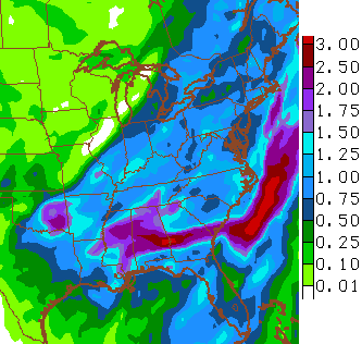 This could lead to some local high water issues through Monday night. I will also be watching to see if this thing can spit out a few strong storms. Winds will also be a big player with gusts to 40mph possible.
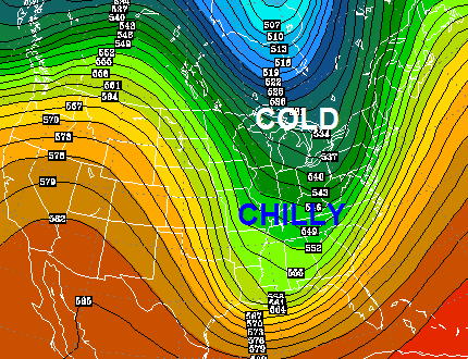
Much colder air sinks in behind this system for Tuesday into Wednesday as a deep trough digs in…
 The good news is we mild things up by the end of the week with thermometers nearing 70 by Thursday. A weak front could deliver a few storms by Friday.
A more pronounced thunderstorm signal is showing up next weekend into early the following week. Check out the next big dip in the jet stream…
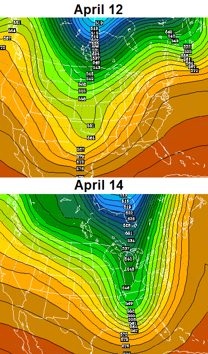 Could that be a severe weather maker around here? We will have to wait and see, but this is a very active pattern that can produce a lot of rain.
Have a great Sunday and take care.

Thanks Chris. Going to get out and enjoy today, but I may have to drag out the galoshes for tomorrow. Glad I have a good raincoat! How ’bout them CATS!!!!! Have a great Sunday everyone and thanks Again Chris for all you do.
Thank you Chris for all you do.
The sky’s are Go big blue today!
Thanks so much Chris.. after three years following your forecasts you are STILL my first “go to” of the day, even here in central WV 🙂
made it to 71 so far today
Absolutely beautiful day.Love the temps.Actually went out and straightened up the garage a bit from the winter mess of just tossing stuff in there.All the feral cats spent the day basking in the sun.
Sounds like the rain won’t last to long so a day or two won’t be so bad.After it dries up I guess it will be mowing time…Lawn is greening up for sure.High 60s here today.
Well I will try posting again,by changing a word.Sometimes I can not figure out what stops my post from being added.
I and others have finally realized that seemingly innocent words like c*l*a*s*s and p*a*s*s will activate the automod. When D*i*c*k*s*o*n County TN (west of Nashville) had their bad ice storm a few months ago, posts about that event were automatically blocked as well.
So one either has to use a new word, intentionally mispell the “bad” word, or insert something along the lines of “*” between each letter.
Glad the better half (wife) and I enjoyed the beautiful wx conditions yesterday and early today 😛 . Good for all the tourists here in Nashville for the Womens’ NCAA Final Four. But clouds starting to really thicken up here as there is now just occasional faint sunshine. Memphis is already reporting overcast. So those to the north need to soak in the next few hours while it lasts.
As perhaps a sign of things to come, much (or all) of Mississippi, Alabama and Georgia now have flood watches up.
Well Chris…just could u give me a shot of when I can finish tilling my garden.it rains enough to keep me from tilling.then not enough days of sunshine to finish.would u start waving your magic wand.thanks for all u do….!!
Rain started in Nashville about two hours ago.
BTW, the radar at NWS Jackson KY has gone tech. It’s estimated that it won’t be repaired and back online until late Tuesday, so wx weenies will have to use other adjacent radars in the meantime.