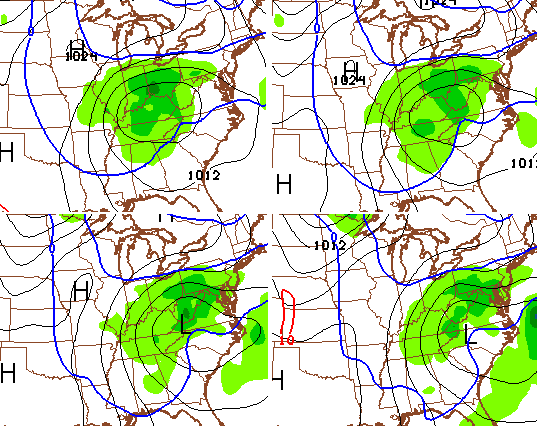
Good Saturday, folks. Our overachiever of a storm system is slowly pulling away from the bluegrass state and it’s leaving a lot of folks under a blanket of white. Snowfall totals were on the hefty side across much of central and northern parts of the state.
A fairly widespread area of 2″-6″ wet snows setup in a southwest to northeast oriented band. I’m not even going to get into the train wreck of Winter Weather Advisories of lack thereof. I’ve been doing weather for 16 years now and can never remember so many counties reporting 4″ or more of snow without even an advisory being issued for them. We all miss on forecasts from time to time, but there is NO excuse to drop the ball on a nowcast event.
The snow will still be flying early today across eastern Kentucky. Accumulations here are a good bet in these areas and we will see if this thing can continue to overachieve. Slick travel is a good bet across our entire region through early afternoon, at least.:


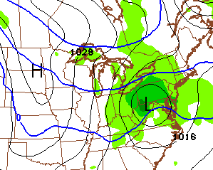
From here we focus on a clipper moving in on Sunday. That likely brings a period of showers and a brief spike toward 40. As the clipper zips through here, a quick switch to light snow looks like a good bet Sunday evening and that carries us into Monday…
That could put down some light accumulations for some Sunday night and early Monday. That’s something for us to watch for.
Another little light snow maker tries to dive in behind that by Tuesday. That will be followed up by another clipper late Thursday and Friday…
The GFS goes hog wild with a potential storm system next weekend…

That’s a system the GFS sees for a while and then loses it. It was doing something similar with the storm that’s pulling out of the region right now. As always… we shall see.
I will have another update coming late today. Enjoy your Saturday and take care.

This system easily broke Winter Storm Warning criteria in some areas. Travel is also a major headache; many people off roadways and even where it looks clear, roads are deceptively slick. Travel is not advised.
I live in North Irvine and we have snow!!!!. I haven’t measured it but everything is covered and it is sticking on the trees, beautiful, and it is still snowing pretty steady.
Here in northern rock castle a easy 3 inches and still snowing. And yes I took pics
Rockcastle
what happen to ARTIC COLD tht was suppose come this week? tx
Models flip flopping is what happened to it.
Why would anyone complain about it?
It would keep the snow around longer!
I’ll take seasonal temps rather than arctic blasts thank you 🙂
If I ain’t getting much snow- the colder air can just stay away.
so Did you get your 2-3 inch snow you had counted on? 😉
We got maybe two inches but I am conscious of being biased 🙂
This certainly pa-ssed winter storm warning criteria for many and the NWS STILL did not even issue winter weather advisories for those places. This was their “excuse” from why they didn’t expand the winter weather advisories from their forecast discussion. “The snow rate is what got the roads slick despite the warmer temps. Decided against expanding the advisory northward based off the lesser impact on traffic, as rush hour has ended, and the chance for roads to improve with the slower snow rates.”
The roads did not improve at all whatsoever in most areas and still decided against it.
conservative – conservative – conservative
I guess sometimes conservative can be a good thing, and sometimes a very bad thing!
I don’t believe Frankfort was under any advisory and we have at least 4.5″!of snow. Beautiful snow at that!
Only thing to measure here is liquid 0.7 inches of rain
Was at Winchester road and it was snowing fairly heavy with already over an inch on the ground at 7PM. Drove to Clays Ferry bridge and the usual light switch effect south of the bridge.
Wifey was stunned herself that Winchester was getting heavier snow and then on her drive home at 930 PM not much after the river towards Fort Boonesborough.
We did get a burst in the early hours this morning so might have 2″ if I round up. Over twice the snow though with less than ten miles span.
My son goes back to WKU today, so I am glad it is going above freezing 🙂
Bubba,
The snow at WKU last night was so much fun. The roads are well this morning with the sun out, so he should be in good shape!
Woke up to a blanket of white here in London. I’d say about an inch of snow. Kudos to Chris.
As he said…completely unacceptable about the NWS not even issuing an Advisory WHILE the snow was falling and obviously becoming a hazard to motorists. They didn’t even follow their own set standards for a snow event!
All hale (or is that hail?
Chris, king of the mets!
Over 4 in SE Lex. Beautiful.
About 2 inches this morning here in Letcher County in seky.
3 miles south of Versailles got 4 inches. Its been a while.
4 inches at the house, and 5 1/2 inches inches 3 miles north at the hospital in Versailles.
You still at the hospital I see. We got about five here at the house.
The NWS issues WWA’s like they were gonna be charged money for them. Too conservative.
Temps are a little warmer here in Carter Co. As of now we have 33 and the roads don’t look very bad. We have maybe 2-3 inches here and it is beautiful.
Just a beautiful snowfall in LexTown. Great walking in the snow last night and a Christmas card view this A.M.
This sneak attack snow was a real treasure.
Nice work Chris!
Go Cats!!!
We actually got about an inch here at my house in Somerset! Not very much but it sure is pretty. Have a great and safe Saturday everyone! I gotta go to work.
Sorry, I meant 30 degrees!
Here in bell county we have 3″ of mud lol
Same here. Sure is “beautiful” isn’t it
Shouldn’t there be some accountability at the NWS? They clearly violated their own rules, misled the public, and attempted to minimize the impact of this storm. The only way to earn the public’s trust is to be straight with them. They should own up to being wrong. That forecaster needs more experience with winter events before being placed in charge of a forecast. Thousands of people were negatively impacted because they were expecting a few flakes. Not even issuing a Winter Storm Warning while 4″ is already on the ground in inexcusable. They didn’t even use their own warning criteria.
Even the basketball goal net is covered over with snow. What a beautiful morning out there.
Waiting on next week. This little snow is just a teaser for us compared to what is coming next weekend. Old skool trend busting thumper.
Did not get but about 1/2 inch here in my part of the Ville. Thanks for the update Chris. Looks like you where right on with your maps.
We ended with 1.5″ in NE Louisville…I know Middletown and Jtown reported 2″.
NWS should bury their faces in a big hole for that poor excuse for not expanding advisories.
Traffic was impacted GREATLY.
Over an inch of beautiful water puddles, 2-3″ of beautiful “green” yard! It’s sooooo beautiful! At least I’ll be able to safely drive to Knoxville today.,
I would not sweat it the majority of the snow that accumulated last night willl turn into water puddles by the end of the day across the state.
We have a couple of inches here in Fallsburg, Ky this morning! Very slick.
Bout half inch here in carrie In knott co
NWS in Charleston dropped the ball big time like they usually do. I just imagine a bunch of goof offs slacking in the office there.
Great job Chris. Your heavier band setup map was right on! We have 4 in. in Chilesburg sub. in Lex. I’d say it was a bit of an overachiever. Was beginning to think this was going to go down as “the winter without snow” lol. Now,IF we can get that winter storm next weekend (notice that I capitalized IF). That would be a good old school snow storm!
Oh yeah, talk about Nowcasting- the WWA was posted after the event already started. Any of us can do that. Jeepers.
CB, put a boot to their butts!
Thank you Chris. You did a great job. You were the only one to even sniff this out a week ago. Your potential snowfall maps were spot on. We really appreciate everything you do for us….GO CATS!!!!!!!
What are you talking about – every met predicted rain to snow and NOBODY got the amounts correct, he even said they miss them from time to time. It’s ridiculous to give credit where credit is not due!
Not true. Chris predicted the heavier band of snow while the other Lex mets were saying trace to 2″.
Meh. You don’t get snow in Beverly Hill.
To expand on Retro’s comment, CB mentioned at least several times that the event was being under played as it began to speed up Friday morning. I believe that he updated his snowfall map to highlight the chance for locally higher amounts in the 2″ zone. The problem is the NWS wouldn’t budge on their forecast even as it played out.
CB did an excellent job with this system.
2-3 inches in Ashland
Be interesting in the coming days watching the models going from jubilation to utter disappointment..Nonetheless looks like someone may cash in on this one while we enjoy our rain..
Beautiful here in Morgan co this morning thanks Chris for all you do for us we got about 2 inches maybe a little more hat to see it melt its so beauiful
The low giveth, and the sun taketh away. By mid afternoon the snow will be a memory.
It was nice on my three mile jog. A lot of overhanging trees on the route, so had several mini snow storms falling along the way. Refreshing without rain 🙂
We got 2″ and was at least pretty this morning. Still wild how a lot of the state can not get any snuv (snow luv).
Tried to get out for a dawn patrol trail run in Veterans Park this morning Bubba… snow was too deep to judge ankle-eaters! Hope to get out on the Town Branch Trail this afternoon for a quickie! It was beautiful though! Looked like an old Christmas card! Woooooooohoooooooo!
Looks like the yard had a slight case of dandruff here in Knox Co. With the low totals we had last season here, it doesn’t surprise me that we missed out on last nights snow also. Still looking for the first measurable snow here for the 2014-2015 winter. This has not been the spot for snow the last two years.
Thanks Chris Bailey for keeping us updated
Close to 2 inches on my farm! Beautiful on the trees!
About 2 inches (on a short ruler) in my part of Richmond. 2 inches more than we have had all year…
5*.0 inches here in SE Lexington (Tates Creek). Chris you nailed it! Looks like it set up exactly like you saw in your crystal weather ball.
Man what a bomb still showing up on the operational..1036 high dropping into the plains with a 1040 high right behind it should help for cold air….Oh only if this was only 1 day from now..
I’m not jumping on anything more than 72 hours out.
Berea reporting in. Though a few straight hours of all rain killed our snow head start over the KY River Yankees, we still ended up with 2″ of a combination of sleet and snow.
Coating to 2″ forecast was correct. Berea Snow Dome still intact, judging by returns just to the north.
I am grateful for that and not only because I wanted to finally see snow again since November. I know how ugly this place would have gotten had we busted either area wide or just the usual busts south of the river.
Let’s get out and enjoy it before the usual sunshine melting happens.
You never know if you’ll see it again. 😉
It is a tremendous sight in northern Madison today for sure.
4 inches at Boones Trace
No snow this part of western k.Y of union.co. s
Chris! Thank you for all you do! I’m from Ohio and kept following you even after you left WSAZ. You were the ONLY one right on the money about the snow! Here in Minford the storm was even an overachiever as we got 4 inches! We haven’t seen that in a year! I almost never comment but I’ve bern lurking for years, and I’ll continue doing so. I’ve learned so much from your blog. Thanks again!
Where the snowpack resides temps are really struggling to get into the mid 30’s. Low level cloudiness has developed in the past hour in the Louisville area. Louisville is 38 degrees but Louisville did not nearly get the snowpack as county’s to the south and east. Louisville warmed quicker but forecast high for Louisville was between 45-49 that might not happen.
Having the same problem with temps and our mud pack
Could that mean we get more snow with the clipper tomorrow? Isnt it supposed to start as rain?
Snow gone here in knott co. Pretty nice day out
Still have snow on the ground at 3:30. Temp 9nly got to 32 deg here today!
Only!
Amazing and typical – Lexington, Versailles, Frankfort … 5 inches or so… South of the river (at least this part of the river)- 2 inches… 10 to 30 miles makes a huge difference…
My history only goes back 10 years here so I need some help with this: When was the last time a “storm” / event has left MORE snow in south of the river (Madison, Rockcastle, Laurel county area) than just north of the river (Lexington, Lawrenceburg, Versailles, Georgetown…). Perhaps we are just regressing tow the mean and I haven’t the history in the area to notice.
Absolutely no melting today here on the ridge in Greenup county…highest we got to today was 30 degrees.
Zip in Bell County except rain and more rain.
Forecasts still calling for 40 degree highs today and tomorrow and it’s not gone above 33 at our house in Lexington and still a good snow cover. Seems to be consistently colder than called for so I’m hoping tomorrow night will bring more snow too 🙂
Hit 41 here in knott co today. Still upper 30s now