Good late Saturday afternoon, gang. Old Man Winter returned to the bluegrass state in a big way last night and that may be just the beginning. The overall setup for the next few weeks continues to feature a lot of winter and the potential for some extreme events across the eastern half of the country.
I’m not going to talk you to death with this update, but I have a ton of model maps to throw your way.
The first set of maps deal with a clipper working in here from late Sunday into Monday. There continues to be a slight adjustment to the south on the track of this clipper. The GFS…

The NAM…
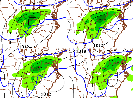
While the track on both models is a bit farther south, we would still need that to drop a littler farther south for the best snows to fly across Kentucky. As of now, showers develop Sunday with a quick switch to light snow Sunday night into Monday. Some accumulation can’t be ruled out. That’s also a very windy system that blows up into a monster as it turns the corner up the east coast. We may see a blizzard develop in the northeastern part of the country.
A weak system dives in behind that Monday night into Tuesday…

That won’t show up well on the models, but you can see the NAM is spitting out a stripe of snow from working in from northwest to southeast. Those can sometimes bring sneaky snow accumulations.
Things turn quiet by Wednesday before another clipper moves in late Thursday into Friday. The GFS…
The European Model…
That may bring another chance of showers ahead of it and light snow behind it.
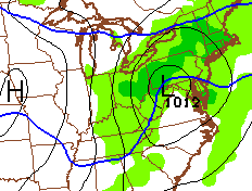
That leads us into the weekend and several models continue to indicate the potential for a much bigger storm system impacting our region. Here’s the GFS…
That’s a week away and a lot can change, but the models have been showing the storm signal for several days in a row.
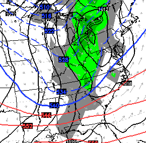
Storm or no storm… arctic air sweeps in during this same time and that’s how we open up the month of February.
I will see you guys later tonight for the full update. Wait… this one was pretty darn full. 😉 Take care.

U.S. Figure Skating Championships are airing today & tomorrow and I am going to enjoy watching during this period of cold wintery weather. Thanks for the look ahead to more of the same as we end the month of January.
Well, Lexington has basically made up for lost time. We are near normal for the season with 6.6 inches thus far. Most came in two events. One in November and this past one. I’m very curious to see how the rest of the winter will turn out.
There is still 3 to 4 inches left of snowpack here in Lex. If we didn’t have snow cover we wouldn’t of had all this cloud cover. That’s because the snowpack sublimates/Evaporates into the air when the sun is out. It rises, cools and created thick low level clouds. It was supposed to be sunny without this snow though.
That’s odd. I’ve noticed sunny days with no clouds with snow on the ground, yet today, it got cloudy. I guess conditions have to be right for the melting snow to develop clouds? A lot of the snow is STILL here and it looks like it only ended up reaching 34 or 35 today in Lexington.
I noticed Chris said we’ve had more snow so far this winter than last winter. That’s wild – but true.
Yes, the right conditions have to be present. Look out at the sky right now, have you noticed all or most of the clouds have dissipated? At least it has in my area, but clouds should increase again tonight because of an approaching low pressure system. Basically you need a strong high pressure to not have the right conditions. That’s usually a-ssociated with bitter cold air this time of year.
Congrats to those who got the snow on Friday! Rodger has had NO snow since November. These maps give him so hope! Looking forward to an “interesting” week.
Maps taken verbatim atm do not equal snow for ones that haven’t had snow yet this year sadly. I’m still waiting on the 1st measureable snow. This time last year we had several.
Rodger understands those maps are possibilities and to be taken with a grain of salt. After this crappy winter, he’s happy to have something to watch (and hope for). Roger in Dodger!
that track is excellent for the weekend.
even if there is a northern shift we still have a few miles to give.
Thought i would ask this again…
My history only goes back 10 years here so I need some help with this: When was the last time a “storm” / event has left MORE snow in south of the river (Richmond. Mount Vernon, London area) than just north of the river (Lexington, Lawrenceburg, Versailles, Georgetown…). Perhaps we are just regressing to the mean and I haven’t the history in the area to notice.
1993 and 1996 two of the largest snow events to hit the state had by far the largest accumulations in the south central and south east parts of the state.
76-77 and 77-78 were a couple of years when the whole state got it but the southeastern part got buried . As for the upcoming week, it does look interesting for sure. I’m the eternal optimist. I think it will….I think it will…
Those are some analogs that many of mets have been using for the end of Jan/Feb going to be interesting to say the least.
The Dusting of 1998:
I lived in Richmond at the time and we had 18″
I can still hear the weatherman on the 11 o’clock news “could see a dusting by morning”… Lol
Thanks everyone for your collective memories. I lived in Richmond as a kids from 77 – 88, moved out of town and then moved overseas to return in 2004. A lot happened between 1988 and 2004.
If anyone thinks we get hammered with snow next week, I have awesome beachfront property in Montana. A few runs ago, the system was over the Deep South, now it’s further north. It will tease us, the the models will converge on a lake cutter by Wednesday.
If any part of KY gets hit it will be the usual suspect-Loserville. I guess we will have all those Loserville Thuginals crying about never getting snow.
Bailey needs to quit including Loserville in any of his forecasts. He hates that dirty town like the rest of us, he’s even said so
This storm will not miss us to the north. A piece of the PV is being pushed into the eastern third of the country. If anything the storm is suppressed south.
Wow, hate much? Thanks to Louisville’s population and tax-generating capacity it subsidizes much of the state’s poor population. Most of the state’s larger population centers do the same, but nothing as much as Louisville. Of course, I realize that’s probably too complicated of an issue for many to understand.
Grow up. Basta.
CB will ban you soon for name calling
CB will ban you for being an idiot!
Speak for yourself and don’t say “the rest of us”. Louisville is a beautiful city….. the center of business, commerce, finance, and culture for the state. If given my choice of a different place to live in KY, it would be Louisville hands down, any day of the week.
Funny you guys from the ville get your feathers ruffled. Guess it’s ok for you all to pick on eastern Ky. Well, Mr Bailey hails from Salyersville. And I want him to tell you guys like it is.
He’s no Loserville fan, I’ll tell you that much. Of the university or the crime ridden city. Go follow Belski and those boys at WAVE. This is a Kentucky blog
Actually, I live in southern KY and have no connection to Louisville. Also, where CB is from has no bearing on the subject either. No soup for you!
Drink another one and take your frustration out on one of Rolo’s goats. If you know what I mean.
Sorry Rolo. This was in no way to put you down. You are one of my Fav’s on here.
Watch it jenks. Article 5 of the blog laws states no mentioning of debauchery with farm animals.
Ridicule the torch, but spare the goat.
I think Lexington, Versailles, E-town were the big winners in this last snow event. Last time I checked, 4.8 inches of snow is a pretty significant event, which is what Lexington recorded. I had 5.5 inches in Woodford County.
Bryant…..Since I live in Loserville and we are all thuginals…and we are a Dirty city…I have a couple choice words for you.
BLOW ME…..blowtorch…….
Sorry Chris! But you have to draw the line somewhere…
Bryant your an @$$
No blowtorch for you. Sources tell me that jenks will get banned this morning.
And that’s good, because my third cousins 8 year old reads this blog and would be hurt by your insensitive comments regarding the torch
technically Newport is the farthest north in the state..you should be jealous of them
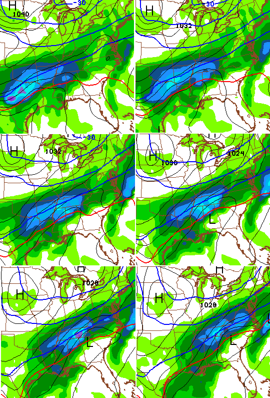
To my untrained eye it looks like the new NAM is continuing a little further south on the 00z run and has a little more moisture to work with as well.
Louisville is a nice city. Let’s watch the criticism and tone. We need to have a good attitude and any part of our great state is good.
PNA goes positive while AO goes negative. NAO goes neutral and MJO is still in a favorable phase. All of this occurs next weekend….and 1993 is showing up as one of the analogs late month. If we get a storm it will be one to remember…we are overdue. I think this will be our best opportunity for a good snow this winter. If we don’t get it…time to focus on spring.
We need to get the old blog going again with Vinnie,WXMan,Rolo. Bubba and others. ain’t nobody got time for the dirty birds from the villle.
In other news, no soup for any of us clowns next week, Bryants weather models are projecting a lake cutter followed by a blowtorch.
I’m also predicting that UK wins their ninth and Loserville falls in the nit. Pitino can be found at porcinis.
Good night and think blowtorch
I think we need to develop our own southeast ky weather blog. As much as I love Bailey Boy,he has neglected this part of the state.
Rolo, , Andy rose you guys are in charge of web development.
Sorry fellas the mud and high water is getting to me.
Thanks Chris for all you do for all of us,it is much appreciated. I was thinking back on a big snowfall in the 77-78 time frame, Chris or anyone was that really big snowfall that we got right before the big flood?
WOW is all I can say.