Good Friday, folks. This is going to be a very busy day as I try to get a better handle on the developing winter storm slated to slam our region later tonight into Saturday. Snow, sleet, freezing rain and rain will all be likely throughout our region. All of this will be followed by ANOTHER round of bitter cold air.
We’re stating this day out with temperatures that are absolutely unreal. Many thermometers will shatter records for the day and could approach all time record cold readings. Rural temperatures will fall to between -20 and -30 degrees. I could see a few reports of lower than -30.
-37 degrees is the coldest temps on record for the state of Kentucky. That was in Shelbyville back in January of 1994. That’s from the same week I talked about this one trying to replicate. And… here we are with a VERY similar week.
That brings us to our next item up for bids… another winter storm. This system will bring snow, sleet, freezing rain and rain to the bluegrass state over the next 36 hours. Winter Storm Watches are out as of this writing and many of those will likely be upgraded at some point today.
Here’s what I think I know:
– This system is loaded with moisture, but isn’t a strong storm. Much of the moisture is overrunning and that usually spells trouble when you have arctic air and a snowpack in place.
– Whatever form of precipitation falls where you live… there will be a lot of it. You could get all forms of precipitation to mix it up a bit.
– I still don’t think the models are handling the thermal profile well and that many areas may wind up a touch colder than the models suggest. A deep snowpack and arctic air will have something to say about that.
– This has the potential to get downright ugly with the trio of sleet, freezing rain and snow. I just can’t pinpoint which type and where. I hope to do that with my next update.
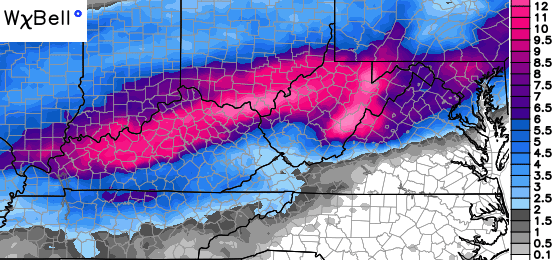
Here’s where the NAM shows the greatest concentration of winter precipitation falling…
The GFS is much more choppy with it all, but the GFS hasn’t exactly been burning up the model world in the past week…
Don’t just look at those maps and think snow… think snow, sleet and freezing rain.
Look what follows all that up by Monday morning…

Next week looks to be another brutally cold week! Watch a system trying to develop late week into next weekend.
Updates come later today and I will be tweeting out the latest model info and the latest on just how cold things wind up this morning. Help me out and tweet some pics of thermometers where you live or throw some numbers at me in the comments section.
Stay warm and take care.

Thanks for the update. I have -14 in Salyersville at the moment.
As of right now same here in barbourville according to computer.
-10 in my part of Lexington as of 2am!
Currently -4 in Owensboro. Temps have risen 5 degrees in the last few hours.
Chris, I have a feeling tomorrow you will max out on your tweets, lol! 😛
Harrodsburg -15
-9 in Irvine. Hope we miss out on the ice. Thanks Chris for keeping us updated. Everybody stay safe.
-15 here where I live in Morgan co
Good grief. Is there no end to this? I still can’t get off my hill from what snow we already had here in Perry County.
Almost same here. Our street which lies on the bottom of a hill was just plowed yesterday. (About time!) And my neighbors and I have been stuck all week, only the bigger vehicles were able to get by. The sun has melted a lot of the snow away now, and we are now able to get out. With this coming, we may stay for another week!
About the same for me.Haven’t been able to get out since I ran an errand early Valentine’s Day morning.Snow still appears to be nearly a foot deep on the hill to my house.With the coming weekend round of weather it looks like I will be stuck at least another week.I prepare for it but you start feeling cabin fever after a few days.Never expected to feel that 25 degrees was a big warm up.Was -20 on my porch about an hour ago so mid 20s will feel like beach weather in comparison.Really not liking this weather at all.:^(
-10.8 here in my part of Knott County. Accuweather has the temp raising before dawn here but I don’t see it. Around daylight or just after is usually the coldest time.
-9 here in Middlesboro
Temp 0 degrees and windchill less near Taylorsville.
Still no maps from CB on what each area will recieve? He must be puzzled on this system. Considering it starts tonight. Lol
Hmmm. Didn’t you read what he wrote. He said he “can’t pinpoint which type and where” so natural no maps for now.
I hope everyone has their water running small streams on both hot and cold. They say running water will not freeze. Tonight will sure prove that right or wrong with these temperatures.
Tell that to the Niagra falls. Lol
Eastwood, KY – eastern Louisville at -12 as of 2:45 AM.
Just got off the AEP website. Power outages starting to show up across Eastern Ky.
-11 in Manchester…Clay Co…
Cloud cover trying to keep temps from falling much in far western KY and much of western TN. Nashville is currently a relatively “warm” 11 degrees.
Snow likely in the air just west of Nashville to northern Alabama, although little of it may be reaching the ground with the dry air. The main action of course arrives later, Winter Storm Warning still does not go in effect until noon. But mets around here (including at NWS Nashville) are still trying to pinpoint how fast the warmer air will move north. Sure hoping the freezing rain aspect will be very short. Anyway, glad that I will be able to leave work early Friday to beat any nasty wx.
Be safe everyone. Also, thanks CB!
On this date way back in 1884 was a large tornado outbreak which included parts of KY and TN although Alabama, Georgia and the Carolinas took much of the storm’s wrath (click here).
Safe to say that severe wx conditions are not likely any time soon, although interestingly the SPC was raising the possibility of a few weak thunder showers this weekend in western parts of KY and TN!
Oh, the snow and cold have already postponed many Sky Warn storm spotter c-l-a-s-s-e-s in our area; check the website of your NWS office for updated schedules.
Hey mark ..keep me up to date with snow there been watching a band form all morning..virga Air is so dry..here in Athens it was -2 here this morning..I hope we can get a decent snow and NO ICE..still alot of people over here still without power…
Hey Tim! Memphis already reporting light snow. Just overcast in Nashville at moment. Like your area, still some ice on trees from the last ice storm, especially south of Nashville where there were still some isolated power outages.
They are getting freezing rain/sleet/snow way down in Mississippi moving into alabama
radar is lighting up in a hurry in your area this morning
As of 3 AM temp is -9 deg on my farm!
Clay City, Ky at 3:15 am, Friday morning reading of -17.3 degrees
-12.2 here now…….
I currently am seeing -18 degree temps in Bulan, Ky. This is about 7 miles from Hazard.
-18 in Frankfort
-8 in Richmond according to the WKYT app.
-32 in Richmond, according to the mesonet station!
a major overrunning precip event is going to center over ky it looks like
What a mess, Chris. TY – all four of you weather dudes at WKYT 27 Weather for the excellent job you have done this week and are still doing. You all are doing the best. No one knows how things will play out weatherwise sometimes until they actually do. This could be one of those times for this weekend. You guys do your best – who can ask for better????????
Winter storm warning for southern Kentucky tonight. Northern Kentucky and Southern Indiana will be upgraded later tonight or early tomorrow according to NWS Louisville.
Well nevermind.
Unfortuately, NWS Nashville has an Ice Storm Warning that will take effect at noon Central Time. Up to a half inch of ice for north central TN 🙁 . You may be next, south central KY.
-20 Maretburg area of Rockcastle county at 4:25 am.
Chris, Im still sitting in awe at the fact that the NWS in Louisville is telling people that this is looking to be a rain event with snow in the beginning changing over to rain! Im just stunned. I mean I dont know man. I wouldnt want to be known as a met. that works there when this weekend turns out to be anything but a rain event with snow in the beginning! God help us!
As it is going I now see they may just be right. Lots of gulf moisture with warm air riding all the way to Indy before said an done. Will start as snow and that is about it here in Lou. Do worry about icing though. The ground isn’t going to warm as quick as the air.
-10 now in Middlesboro.
-18 at my house in Knox
As much as I like the NAM in this close (0z run), the setup is very complex, especially trying to figure out where Louisville will fit with the varying types of precipitation. NWS Louisville says the Low will track right over Louisville. However, a small deviation in the track, perhaps just 10 to 15 miles, may make a difference between mostly snow and some sleet to mostly sleet with some rain.
Also, my temperature has just reached -9 degrees in Valley Station
I’m with you. Going to be an extremely tough call, trying to put numbers this.
If the low tracks right over Louisville dynamic cooling one would think would occur. That can spell all sorts of nasty problems
Minus 12 here in Grayson…..60 degrees in my house.
-11 here at 5 am, just off Clays Mill Rd, near Jessie Clark school, south Lexington
-17 → 3 miles west of Winchester.
We are under a WSW here in NEKY for 3-6 inches of snow, sleet and freezing rain from 7 p.m. this evening until 5p.m. Sat. Oh, yeah, winds gusting to 25. Yikes.
-18 Just Outside Prestonsburg & Forecast Apps have been Showing a Rise in temps for the past Few Hrs. but they have Continued to Drop.
Although, My Son says that Temps Did Raise 4 degrees Earlier but, then Dropped 5 MORE After that & is Currently @ -10 in Richmond ??
Floyd Co. Ky. Has Some of the Craziest Weather Outcomes in the Winter months !! With not Only the North\South Thing but, Also the Southern Half of the County is Much Higher in Elevation !! Lol
2 Different Worlds !!
According to the NWS, it is currently -19 in Frankfort.
-13 actual; -28 with wind chill factored in now. Near Jessie Clark school off Clays Mill Rd., Lexington
My husband just drove home from work and the theometer in the truck was -16 here in London.
I should have proof read. Thermometer*
According to ky me sonnet it is -31 in Richmond ky
I like the idea of a “me sonnet”, kind of poetic, really 🙂
Ky mesonet
Faye – I read where you drove from Lex to north Jess and the temp dropped from 3 to -11. That’s so weird. I guess all the traffic and cleared pavement? I’ll bet the temp around different parts of the city of Lexington are dramatically different at this moment. If anyone is out driving this morning around town and sees this, share your info.
In the past I’ve seen people post low temperatures that differed dramatically from the official low temps and I wondered if they had faulty thermometers or read it wrong. Now, I’ve seen it with my own eyes. I still don’t understand how it happens, but I now know temps can vary greatly over a short distance.
-15° F in Danville. Bleh. My lungs hurt.
Cigars or cold? Hmm. 😉
Stay safe if you’re out there on runs today.
Haha only one bowl on my pipe earlier this week. 😉
-17 now in Danville.
-18 in Winchester as of 6am.
-10 when I left home in Nicholasville. -18 to -22 on my drive to Harrodsburg..
-20 in Corydon IN :/
Just saw the latest nam snow map, not good for most of ky, but Cincinnati may get more than a foot of snow. Looks like Lexington Richmond area may be the bullseye for ice,
What bout ne ky
-17.0 DEG F 2mi NE of Allen in Floyd Co.
Any idea on timing for tonight’s precipitation from the Georgetown to Cincinnati corridor?The plan was to take the kids to a concert and heading up looks OK. I’m not sure on what to expect driving back (11 PM CIncy, 12:30ish Georgetown)
“This system is loaded with moisture, but isn’t a strong storm.Much of the moisture is overrunning and that usually spells trouble when you have arctic air and a snowpack in place.”
One of you more knowledgeable cats (or Chris): does “trouble” refer to more precip. or ice, or does “trouble” mean trouble for the intensification of the system?
06Z NAM : http://wxcaster.com/gis-snow-overlays2.php3?STATIONID=LVX
06Z GFS:http://wxcaster.com/gis-gfs-snow-overlays2.php3?STATIONID=LVX
neither doing a thing to clear up this muddled mess headed our way.
A true NOW CASTING event
I like the GFS better Six inches of the white stuff. Looks like the NAM is warming a bit for snow may go over to freezing rain sleet sooner and cut down on snow totals. As Brian Goode said this has a huge bust potential. Let’s hope Mother Nature sees it different.
I’ve got -14 on the Southwest Side of Lexington.
-16 in NW Lexington, at 6am
Driving through G’Town, hit a low of -22 at exit 126
temps are all over the place as I drive north, anywhere from -12 to -22
Bottom line, it’s cold folks, stay warm
-20 in Hindman ,Ky
-24 on the thermometer in the truck here in Olive Hill.
-32 from Madison Mesonet. Berea temp is -31 to -33.
Hard to believe it’s going to be a balmy 50+ degrees warmer from right now for the high today.
The outside temp may be approaching what we had in Jan ’94, but as someone who was out in it, I can tell you it doesn’t feel near as cold right now outside. The wind in that event felt like it was going through your clothes into your soul and out the other side.
Hey, it’s a dry cold 😉
I know, and I’m glad. I’m also glad we didn’t break that state record. Yeesh.
-20.3* here in western Frankfort
I think we already have our answer that all the above will fall. CBs fun will be to figure what type will be the most significant over the areas south to north. There are nor-easters and now we have a now-caster 🙂 Hopefully our power stays on 🙁
I have -31 north of Athens in Clark Co.
in 1994 we were supposed to change over to rain. it never happened
They just mentioned the madison county -32 temp on AMHQ on the weather channel……
My water is frozen in my master bath faucet EVEN though I had a heater running in the bathroom and the cabinets opened!!! The toilet isn’t frozen, and I can still get warm/hot water from the faucet, but turning it on cold, nothing! I thought since the heater and cabinets were opened that I wouldn’t need to leave it running. I guess I underestimated it……..At least I can still get warm/ hot water out of it……That’s the only part of my house that’s on an outside wall…..
-16 in Corbin….
-18 on my trip from Nicholasville to Wilmore. Started out at -8 and about 2/3 way down 29 the temp plunged.
Its -13 in stopover in Pike County
Chris it is 25 below in Hillsboro kentucky in south eastern Fleming co and also had the same temp yesterday keep up good work Chris
-22 @ Stricklett area of Lewis County.
-18 Scottsburg, IN
so we could get heavy snow with backside rain? that’s definitely a 180 from the normal rain with backside snow
I know, you think of heavy snow falling will cool the atmosphere, not warm it to change it to rain…..the other way around sounds more usual.
You may have a rain sandwich. Temps dropping like a rock on Sunday could change you guys back to snow before moving out.
Looks like the snow line may push all the way up to Dayton. Looking more and more like 2009 to me.
21* Below Zero @ 8:00am Langley , ky. Floyd County. burrrrrr
It’s -23 in Blaine, ky this morning
Severe thunderstorm warnings going up in parts of the south, those may help to keep Snow totals and ice totals down as they will be moisture hogs
So Lexington officially dropped to -18°F this morning! That’s only THREE degrees from the all-time record low, and shattered the previous record by 18 degrees, something I’ve never heard of before coming from a climate station with data back to the 1800’s! The previous coldest I had ever experienced was -11° in Minnesota. I never would’ve thought I would see that low again, because I moved here to KY, mother nature proves me wrong. It’s crazy to be outside, the air feels heavy and hard to breathe and your nose freezes, something I haven’t felt in years, and only once. -32° in Richmond? Wow, only 5° shy of all-time coldest KY record. Looks like 1996 will stay the champion.
* correction, 1994*
LOL! Seems so wrong! You lived in Minnesota and Kentucky, and the coldest temp you’ve ever experienced out of the two states was Kentucky.
I had -20 on my home thermo and -20 on my vehicle. Marehaven subdivision off of Alexandria Road… Near the intersection of Leestown.
For CB to lighten the mood a little. Keep killin’ it man.
Figuring out this weekend storm be like…
http://i.imgur.com/gv2f6nH.gifv
We’re supposed to warm up by 50 degrees, and it still won’t be above 30. Just for perspective, if we were at 30 degrees now and got a 50 degree warmup….imagine.
Where is this happening? There is nothing remotely close to 50 degrees occurring????
Nvm. I read your post wrong my bad.
Totally good point… That would be craaaaaazy! 30-80!
-17 Heidrick southern Kentucky
It’s -16 in Ulysses, Ky.
It was -23 in rural Greenup County, KY this morning. It was -10 just outside of Flatwoods, KY.
-26 here in Clay County. BRRRRRR!!!!
Two separate vehicle readings of -23 as of 7am, Dry Ridge, KY.
Here’s what the 4k Nam is showing..Cant tell if that’s .1 or .25
http://tapatalk.imageshack.com/v2/15/02/20/9788414a591d32444ee420b5b698d360.jpg
-13 at 4 am in Pikeville.
A lot of people without power that way looks like.
-25 Greenup County, KY @ 6:55am
im sure it will happen and im probably wrong but I just cant buy a major changeover to all rain …maybe freezing rain or ice …but not an inch or 2 of rain ….I ll have to see it to believe it and like I said , Im probably wrong
and also here locally , yesterday the weather channel had temps at 40 on sat and sunday…this morning they r at 35 and 34…I think even the idiots there r figuring out the snowpack/arctic air
This storm has me worried. Ice is not nice.
-15 Catlettsburg
many without power dis morning. prayers
Power is out in part of Madison Co.
-9 in my corner of Harlan County at the moment.
-11 in bryantsville and electric has been out since 3:50 this morning….brrrrrrrr
Hit -27 on the car thermometer South East Clark Co this morning
It’s -23 at our house this morning in a valley down in jessamine county. Them temps coming up and that rain on the way may help warm us up and melt some of this snow. I ain’t seen nothing like this since I was a boy. I am ready for the warmer weather.
I have seen so many different forecast this morning. This storm is going to be tricky tricky I’m afraid.
Right?! I’ve switched from 3 different stations in my area & I’ve gotten 3 different stories.
From the sound of the ‘forecasters’ in Bowling Green (and nws) we are going to get torrential rain… I just can’t get excited about the rain washing the beautiful snow away 🙁
Shew all you DAs come on here wishing for a big storm, whining and crying about getting no snow … Then we get one and you’re the first to start crying all over again asking when is it going to end, or I’m so sick of this…. Well you wanted it, now face the consequences that come with it.
Nice.
name calling? not needed to make your point.
I said the same thing yesterday ….on here begging for it …then we get a week or 2 of true winter , and people are done …..its funny
Without name calling… very well done 🙂
true 🙂
Maybe it’s funny, maybe it’s not. It’s simple. Some of us wanted so badly, and we got our fix, now it’s time to warm up….I think it’s funny that that’s so hard to understand.
How does Axl know there are a lot of District Attorneys on here?
Very well said Mark. Too much of a good thing can often be as bad as nothing (especially with this upcoming forecast). I have a feeling 99% will be begging for winter to leave after this weekend…
THIS!!! Tell the turncoats 😉
And to think that I am the troll around here…..Axl that is pure bush league BS.
Time to remove the banana from that tail pipe.
Shortwave rolling across the south now will only confuse the model sampling more…
I get the feeling, most if not all meteorologist are scared to death to make a call for precip type! I mean, it could be ANYTHING
I agree. I’ve not seen hardly anybody throw out numbers. This is new for most everybody.
My head is spinning from all the different scenarios. I think I might just stick with common sense. Ground frozen probably at least 8 – 12 inches deep below a foot of frozen snow and 5-8 inches of heavy wet snow. I’m going to guess the rain will freeze before it can melt much snow. Then Sunday night Kentucky will be an ice rink..
The groundhog biting the guy’s face in PA is turning out to be incredibly prophetic.
My husband’s car read -17 on his way into Ashland from Cannonsburg at 750 this morning. Mine only got down to -14 between Summit and Rose Hill around 8.
Here’s another issue that may need to be considered and may already have. If we go cloudy before noon one would think take away any significant warming? With a heavy snowpack temps below zero and clouds fast approaching really don’t see how to warm surface temps all that quickly? This kind of reminds of 1994 to some degree.
Another interesting note… Last night my weather app had my location to be above 10 by 10 this morning. Well I am still below zero. So it is having a hard time warming up this morning.
Rodger seeing the Paducah NWS going with the warmer forecast and Louisville NWS leaning to the colder scenario. Not surprised that Paducah almost alway sides with the GFS. Gonna be interesting. Mr Bailey’s take on winter storms is the only one I put any weight on. Rodger in Dodger!
As of 853 this morning NOAA has Louisville in the snow sleet and freezing rain no rain mention I’m sure this will change though.
Still -10 in London at 10am, whereas most others are at around 0. Is this is a sign that SE counties may stay a bit colder for the next event? If so, would that be a good thing?
Actually up to a whopping 1 degree, so temps are really rising fast as the high pressure departs. Still, it would be crazy to go from minus 16 and a 12″ snowpack to heavy rains and 50 degrees in 24-36 hours. But, it’s Kentucky, and anything is possible.
I have expressed concerns about valley areas, as cold air seems to stay trapped at the surface…icing issues
12z NAM shows less snow but more ice that’s terrible news. North of I-64 decent snow showing up huge cutoff from snow to ice.
Could it be 2009 all over again, let’s hope not
No one wouldn’t think so 2009 was a long duration event. In my opinion this has small similarities of 1994.
10 am & still -8 degrees here. I have 8 to 10 inches of snow still outside my door. The forecast I’m hearing is 3 to 5 more inches of snow then freezing rain then switching to rain that will melt the snow. I’m far far far from an expert but I just don’t see how that can happen.
well CB is up and tweeting …..still saying very ugly …hes gonna have long weekend im afraid
This is a very ugly winter storm moving in tonight & Saturday. Significant amounts of sleet, freezing rain and snow. #kywx #WKYTRulesWinter
Chris seems to think it is going to be UGLY….
still not suggesting rain ….hmmm
Sun disappearing in Louisville now. Hoping this won’t be a repeat of 2009.
It wont that was a long duration event
We all need to pray for CB, honestly.. Pray his eyes don’t cross, his head don’t explode, and he don’t have a mental breakdown while trying to figure this thing out. We need him! I know we all trust him with our choices we make during these events.. Do we spend out last $50.00 on bread and milk or not; Do we buy extra kerosene for heaters, gas for generators?? Do we let out kids stay at a friends house or rather have them home with us?
I personally want to thank CB, a ton for what he does for our area.. He has no idea the effect of decision making for each one of us he has, little ones and great. So say a prayer for him that he can stay calm in the storm, while the rest of us lose our minds, and he can focus on what is at hand. Okay, sappy statement over, but felt like somebody had to lift him up at this moment..Lord knows I would not want to be in his shoes right now!!!
I agree well said what would we do without our CB.
Winter Storm Warnings/Ice Storm Warnings extend all the way south to north Georgia, near the Atlanta suburbs. winter weather advisory for Atlanta area. Really hard to think that this will end up with 40 degree rains for any part of KY.
FLOODING the story here nothing more.
Rolo, maybe where you live.
But, dismissing this as nothing but flooding, just naive.
Role get boat and the Ice pick and pick me up.
Confused about this one. Hopkinsville downgraded to WWA but Clarksville (15 miles south) upgraded to Ice Storm Warning. Not sure what we will get.
Here is the snowfall map for 12z NAM:
http://wxcaster.com/gis-snow-overlays.php3?STATIONID=LVX
Once again, I-64 seems the battleground for evrything. It still is showing anywhere from 1 to 10 inches of snow in Louisville, south to north.
See how much bust AND surprise potential this has? It really is a once in every 20 year type of winter storm.
c-biv, I live close to you just across the county line on Hwy 22 in Oldham! This map shows a foot for us, wow!
I know you are talking about Kentucky. But I live just yards from I64 in WV and it is never a battle zone here during scenarios like this, rain always win. Matter of fact I think it is undefeated.
I don’t think the models know…Bailey’s comment about the temperature profile being critical to the forecast is right on in my view…and the models can only guess on that. IMO we will know what it is going to do when it does it…by looking out the window. Overrunning moisture is always a problem to forecast. So don’t be critical if the forecast for snow turns out to be ice or vice versa. Everyone can guess on a forecast but the level of difficulty with this forecast is very high compared to the Monday snow.
c-biv, any idea what the nam had for boyd? Thanks.
Anywhere from 5-10″ south to north based on latest run:
http://wxcaster.com/gis-snow-overlays.php3?STATIONID=JKL
Thank you!
It was -32 on Forkland road in Boyle County @0700 hrs. this morning.
Whats the deal with all the gray? No snow in these areas?
on the latest map you guys have posted. Seems a lot of counties can go from nothing to 12″
I think it’s great that we have a site like Chris’blog to be able to complain if we choose about the weather. We all do from time today. I’m just greatful I’m still able to and not six feet under. It’s good therapy. But the name calling is totally uncalled for. With school out,there are more children reading this site. Shame on you for name calling.
Yeah, it can be good therapy. Some however might need to consider their constant complaining or venting. No need for multiple times a day, every day unless you need other help really.
As for this weather it was obvious many wanted it and then would be ready for it to be gone. I heard a lot of family/friends complain about wanting snow. They get the snow and immediately were ready for it to be gone and spring to hit. If that had happened they would have complained about how fast it melted.
How much ice is expected for southern Kentucky?
The latest suite from the NAM 12z run shows freezing rain for a good chunk of Kentucky by 1:00am est.
However, the RAP 14hr for midnight shows snow and a mix for many areas of central and north-central KY with freezing rain confined to far western KY.
These models will short-circuit by the time this is all said and done
Thanks.
Looking at the longer range models, spring roars in here in 2 weeks, with some possible 60 degree temps in 15 days,
I’d take that with a grain of salt
Maybe, but we are cloising in on that time of year. Avg highs for the first part of march is low 50s in central ky
Closing
On a scale of a 0 to let’s all run to Kroger for milk, bread, and eggs what are your thoughts?
I can’t help but think it cannot get any worse around here.
I am leaving soon to go to the grocery. It will be interesting how things are going once I get there.
By the way, I think Pandora is a very appropriate name. Here is the definition of Pandora’s box from one site:
“…opening pandora’s box refers to getting into a situation over which one has very little control over.”
I see that temps have been adjusted down a lot of places for my area. Was seeing 40’s predicted yesterday and now down to the upper 30’s. Except accuweather which has held firmly to the mid-40’s. Weather.com is now calling for 1-3 inches tonight and 3-5 inches tomorrow.
NWS Jackson definitely changed. They show my area as 5-8 inches and .10 to .25 ice.
I understand this is a hard storm to forecast and not calling out any one place. Just pointing out how much they have changed in their thinking. And pretty much how the forecasts very. Crazy to think but NWS Jackson is the most wintery with temps and forecasts with weather.com in between when considering temperatures and then the all rain accuweather forecast.
Thanks Chris Bailey for doing a great job on this site. Will be looking forward to the updates and getting a better picture of things.
Where is your location again?
Interesting note: Both WAVE3 and WDRB both in their hourly forecast have Louisville at 12 degrees at noon. It is 11:52 and we are currently sitting at 7. Is that an indication of what may be to come?
NWS in Louisville is still showing 40 here, Saturday, with heavy rain. Light accumulation of snow and sleet before changing over.
In about 3 hours we will see what they say with the new update.
My car said -21 in Burgin this morning
Am I understanding this correctly? I am in Mercer county and we are getting rain maybe snow? Not much being said about ice. Can someone enlighten me? Thank you
NWS in Louisville is calling for the temps in Frankfort to get to 22 today. Its noon and we are sitting at 7. Something is not making sense. 95% cloudy and the wind is out of the south at 6..
Bowling Green is forcasted for heavy rain and 33 degrees at 1am…
what a mess…I dont think we know till we know
Interesting that the HPC has much of Kentucky in the slight risk of 4 plus inches of snow, including some in the moderate risk, and slight risk for 8 or more inches. They also have a slight risk of more than .25 inches of freezing rain, with some overlap. Not quite sure what to make of it! http://www.hpc.ncep.noaa.gov/wwd/winter_wx.shtml
Wkyt just said 1-2 inches of rain.☔️