Good Wednesday, everyone. Additional rounds of heavy rain will target the region through early Thursday, leading to an increased threat for high water issues. The area of greatest concern continues to be across the south and southeast.
Once all this blows through, temps drop and we finally have accumulating snow chances to end the week and into the weekend. I’ll get to more on that in a bit, but let’s begin with the flooding potential. Here’s a look at the Flood Watch…

After a little break early today, the heaviest rain of the entire event will be possible late today into tonight. That’s when some thunder tries to get into the mix. Another 1″-3″ of rain will be possible, especially across the south and southeast.
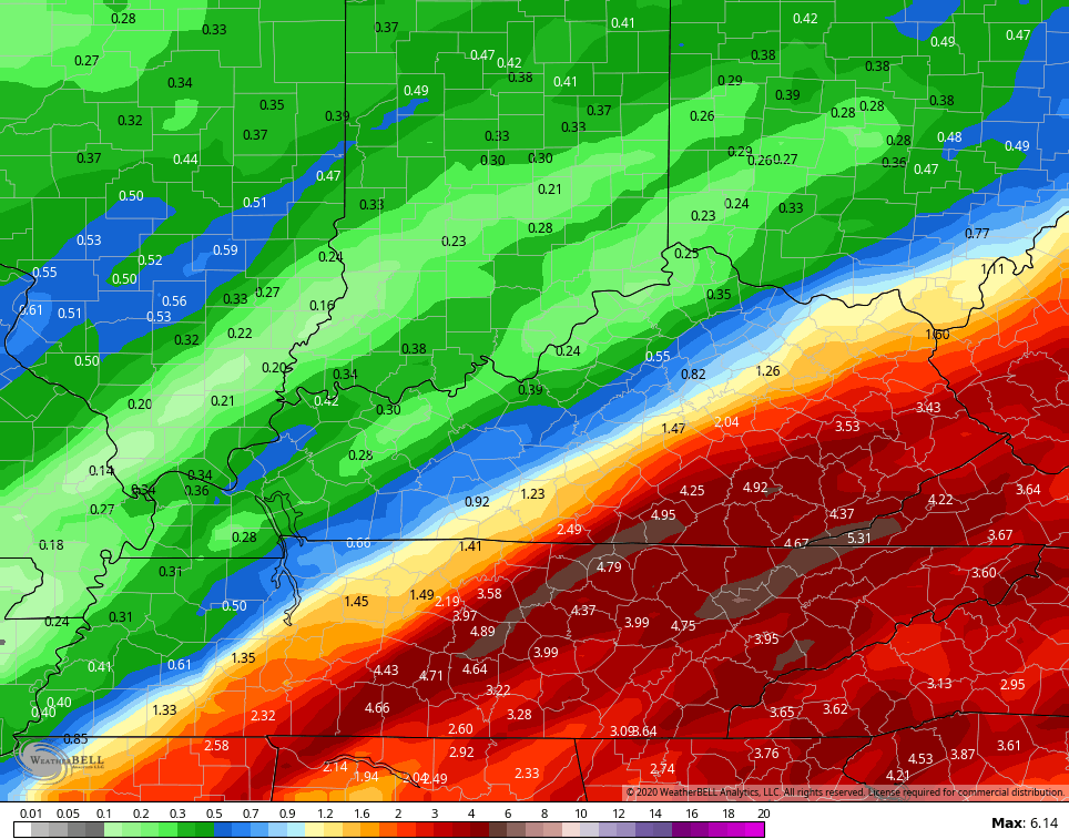
The GFS continues to show some big time numbers…
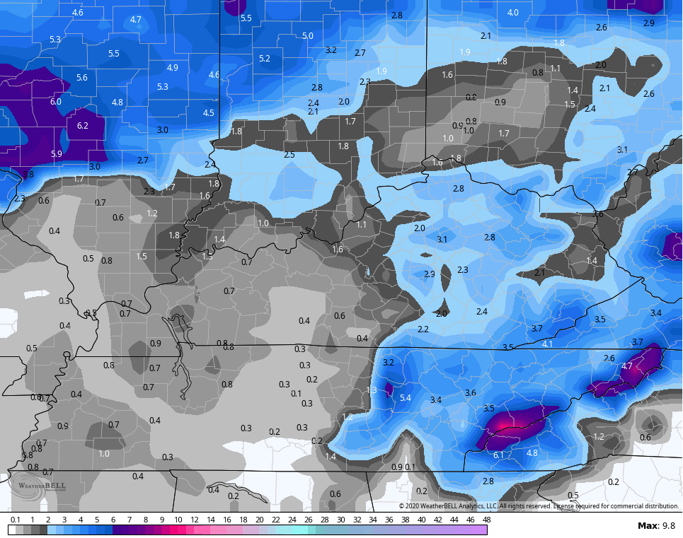
 Here’s the NAM rain numbers…
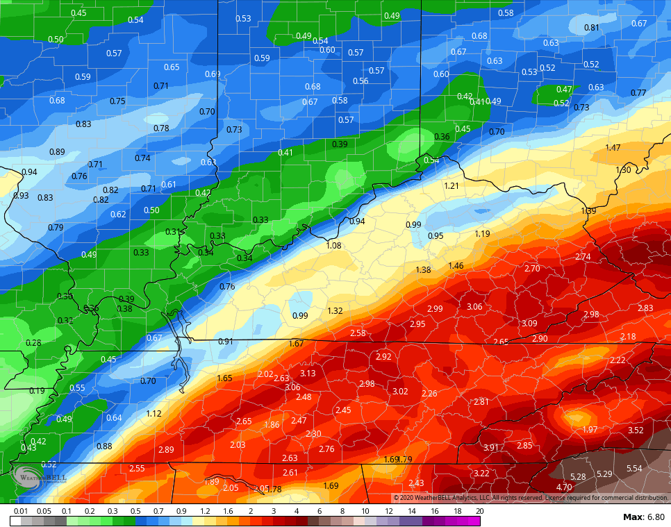 If those numbers are realized, flooding and flash flooding could become a big issue in the southeast.
Here are your Wednesday tracking toys…


Colder air crashes in as another wave of low pressure passes by to our east late Thursday into Thursday night. Light snow develops across the state, with the greatest emphasis on central and eastern Kentucky. With temps dropping into the upper 20s Friday morning, light accumulations appear to be a good bet.
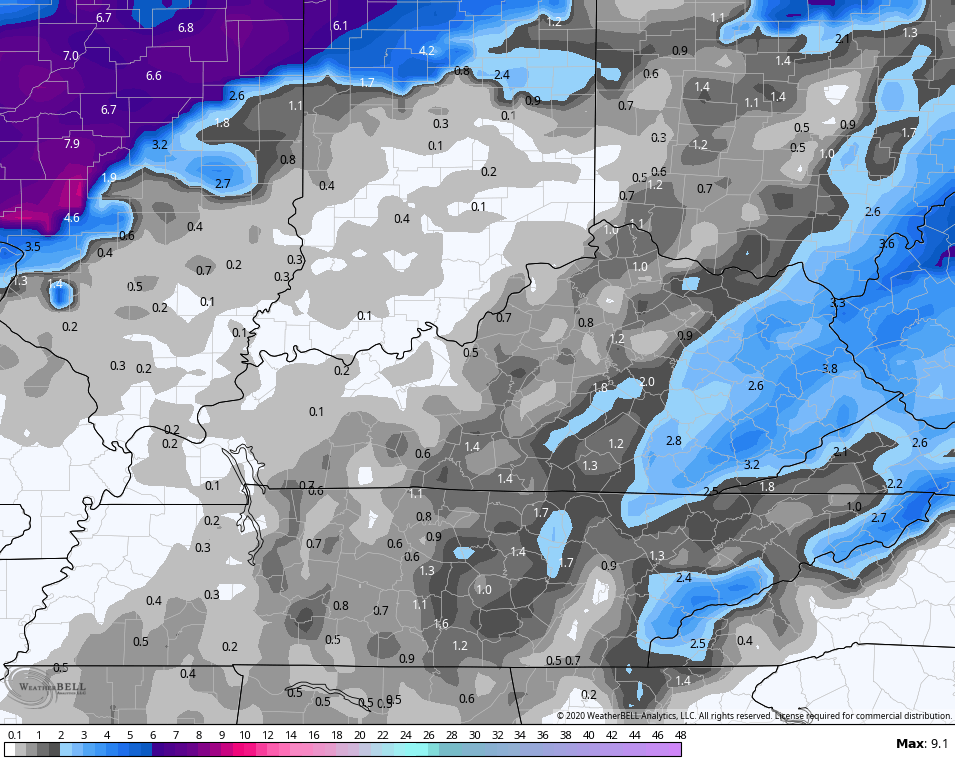
The NAM really likes the snow potential with this…
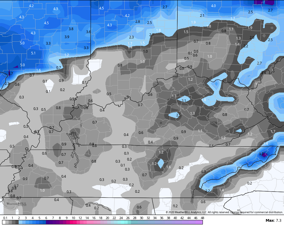
 The GFS is seeing more of this potential…
 It’s possible for some delays and cancellations Friday morning.
As the Friday system shows up a little stronger, the overnight model runs are trending weaker with the Saturday snow maker. The GFS does add some light accumulations on top of the Friday action…
 I will have updates later today so check back. Have a great middle of the work week and take care.

Rain is getting heavy and starting to train in Harlan since midnight. I am now working on 1.50 inches for the event, but starting to add up much faster than the 1.04 inches yesterday which took all day to fall. I think the GFS verifies and we have some big issues by Thursday morning in my poor ole soggy Harlan, KY home.
1.45 so far in the South Williamson area
You are also in line for a good 2 to 4 more inches of rain. Too bad these weren’t snow maps instead as this is a big rain event for our areas.
1.71 at my house since we started
Weekend snowfall is already looking like a bust.
Now, is that a positive attitude? LOL…Truthful attitude trumps positive. Temps aren’t there anyways so I am only concerned with the RainTrain for now.
Debbie, sometime later today, let us know how much snow you got to witness out there in the great state of Oklahoma please! Bring us other starved out snow lovers some back too, lol.
Happy national weather persons day but please keep the rain lol
I knew this snow wasn’t going to hold together by Saturday. I’m looking for it to diminish all together. I’m so over it.
Either the GFS is on steroids or Harlan is in major trouble later today. New run is for over 6 more inches of rain and this is mostly for tonight and tomorrow. Scary thing is, GFS has been pretty accurate lately. Other models are less, staying closer to 4 inches more but still. GEEZE
I hope the models have over estimated the rain for your area. As for me I picked up .29 of an inch yesterday, I knew it wasn’t much since a lot of time it was drizzle. The temp has dropped about 20 degrees since midnight but is supposed to go way up again tomorrow. I am not anticipating more than some wet flakes Friday/Saturday. The ground too wet/warm and temps borderline.
Thanks Chris, and Happy Weatherperson’s Day. Yesterdays rainfall in my backyard was at 4 inches within 48 hours. The Kentucky Mesonet had our total at 2.13 inches within 48 hours. That is a big difference ! Usually my rainfall totals equal the Kentucky Mesonet. Go figure, must have had an extra shot of moisture. No comment on the upcoming weather for today through the weekend. I can however tell everyone that the upper levels of the Atmosphere have not changed Globally.
RIP snow
Kentucky is a prime area for cold = dry and warm = wet, during more polar centric cold winters. It’s a natural process every 30 to 50 years and keeps the polar caps doing their thing.
Humans and their silly, the world revolves around me, mindset is futile. Our time here is truly a statistical blip for true weather trends. Deep stuff, unlike our snow the past several years.
Terry-I apologize how I phrased that comment and/or how you took it. You made a comment about the “rain-train” and I said I was going on the westbound-making a joke! I wish I was in OK. It’s snowing like NUTS out there right now near Tulsa. This is likely the biggest snow they’ve had in several years. Yesterday, one of their mets said if the 4-8″ verified, it would be the first time in nearly 7 yrs. they’ve had over 3″ of snow. I called my 92 y/o aunt yesterday but she couldn’t talk long, and even though I could hear her radio on in the background, she had no clue they were under winter storm warnings! (And yesterday was one of her GOOD days… 😉 ) I’ll call her later and find out, then report back! That may be the only excitement we get snow-wise, Terry! Live vicariously through my folks 739 mi’s away! haha!
Oh shoot, lol. Read too much into that post, LOL. Dang, I thought one of us snow lovers lucked up as they are getting slammed right now. Boo! LOL.
Well, I know how the convo is going to go. As I said, my aunt is 92, and she’s just recently going back and forth on her “faculties”, if you will,lol, sooo…I’ll ask her how much snow they have, and she’ll tell me they haven’t had any snow, then she’ll ask my uncle(he’s 85 and never ages)”Bob?! We ain’t had no snow for how long now??!” and he will reply, “We got 6″ on the ground! Gads….”! btw, not making fun of her or ppl of advanced age-it’s just odd for me to realize that the “Betty White” of our family is rolling downhill at such a sudden fast pace!
Nonetheless, Terry, I’ll let you know. I just watched a Tulsa station and the rain/sleet was just changing over and roads already covered. I wish I was there!
Debbie, we use to have weather like that at least in south central Indiana. When I was going to Murray State University from 1971 to 1974. Not one snow event was recorded. In fact there was a huge Black Jack Oak tree that stayed evergreen the entire four year period. I do remember one major Ice Storm, but it melted within a couple of days of mild temperatures. A very mild and mostly dry Winters back then until Fall 1976 came.
Coating powah!