Notice to all the first time readers… the charts below are computer model forecasts and not an actual forecast from me. 🙂 Happy reading and keep checking back for updates. Click on the banner at the top to take you to the main page.
Good Wednesday, folks. We’re starting out the day on another below zero note for much of the bluegrass state. The brutal pattern of January has been something to behold in our part of the world. A new pattern is developing as we head into February… one that’s taking on a wild and snowy look.
As usual… let’s start with today. After the bitterly cold morning, temps rise into the upper teens and low 20s this afternoon. Your temperature tracking toys…
Today’s lows

Current temperatures

Thermometers will slowly warm into the 30s for highs by Tomorrow after we start the day out around 10 degrees. The first of many storm systems will then impact our region by Friday into the weekend. This is likely to be a messy system that throws rain and snow our way on Friday. That should switch over to rain for Saturday, then may go back to snow or a mix on Super Bowl Sunday. The GFS shows this well…
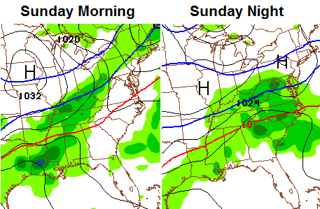
We will have to keep an eye on where that magical rain/snow line sets up because accumulating snow will be possible for some.
The next storm is the one that’s been getting my attention because it looks to be massive. The growing trend among the models is to get colder with this system. The GFS…
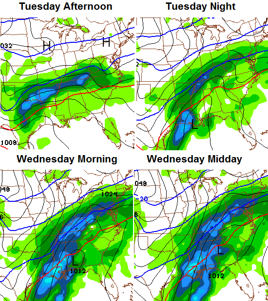
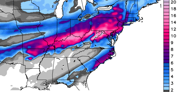
That’s a very ugly scenario across Kentucky as it would mean a ton of snow and ice. There’s almost a February, 2003 look to this. Anyway… check out the snowfall forecast from that model run…
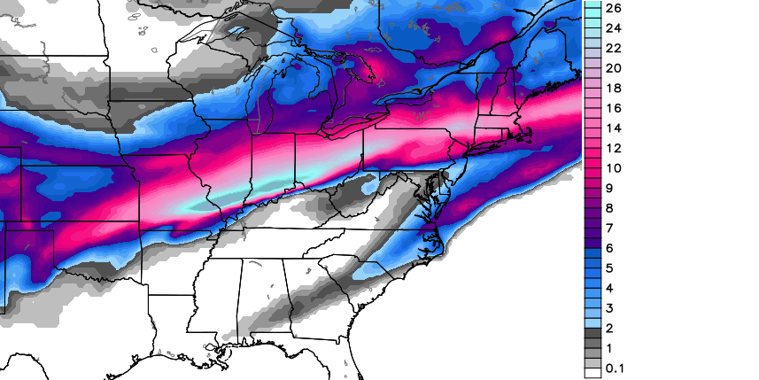
The Canadian Model isn’t as wrapped up as it was with the earlier runs and is focusing it’s winter weather farther south that before…
This has all the makings of a major storm for our part of the world… one that has a tremendous amount of precipitation with it. Whether it be snow, ice or rain… there’s a ton of juice possible with this prolonged storm.
We have plenty of time to track it, so let’s see how this plays out in the coming days.
I will have regular updates during the day. Enjoy it and take care.

Chris, I always appreciate it when you take the time to update us on the weather, but when you see something in the works like February 2003 again, I ESPECIALLY appreciate the heads up! You mentioned a word that causes me so much stress – ICE! That time was a terrible stretch of weather for my family, as it was for so many. Our electricity was out for days and we had a seriously ill son at home, too – we ended up having to go to a motel to provide him with the warmth that he needed while recovering. It was such a difficult and stressful time that I don’t EVER want to repeat it again. Personally, with the threat of ice looming, I hope that the infamous “bubble” holds strong because of the hardships that icy weather can present for so many people as well as their pets and livestock. I know this won’t be a popular comment with many, but it’s just the way I feel where ice is concerned.
Thank you, Chris, for giving us this look into what we may be facing so that we can at least start preparing if necessary and especially thank you in advance for keeping us updated as the storm develops. We do appreciate all that you do for us! This is one storm that I know many will be monitoring closely! Have a good day, everyone!
No, I agree with you. The lesser of those two evils is definitely snow. I wouldn’t like to be without electricity for a week like I was in February 2003.
I totally agree with you. I have a farm and had no power for 8 days. It was way worse than the hurricanes I’ve been through. This current stretch of absolutely ridiculous cold has been no picnic either. In spite of insulating the pipes and dripping faucets I’ve had no water in the house for 2 days now. I almost don’t want to read this blog anymore because it stresses me out, but I need to know so I can prepare as best I can.
What ever happened to global warming?
There is a HUGE difference between a localized system or pattern of weather and global climate change. The world is a great big place!
It’s all in DC!!
Don’t be daft. When you see people on Fox News, showing pictures of snow and saying “hah! Global warming huh?” Those people are idiots. Don’t be like them. You don’t find it odd that generally warm areas are having the worst winter in 20 years, and places that are generally cold are having record breaking high temps for their region? This is our downfall, and it’s happening even faster than they once thought. We can either accept it and start dealing with it, or send our children and grandchildren to their demise. Whether you want to do that based on your learned politics is up to you. Personally, my child’s future is more important to me than any right/left paradigm.
One of the most intelligent responses I’ve read yet to people who make ignorant comments like, “What global warming?”
Everyone is destroying this planet for their children, grandchildren, and as far as the family line will extend…
CB, you rock but wish the ice word was not mentioned, since we know what that would likely mean for a lot of us. Snow tends to not be the main player if rain or mix is part of the precipitation possibility and ice seems to bully into it the main action too. Warm air has a way of dissing snow around these parts. Uncanny.
I bet this comment makes it and my previous doesn’t. I was just commenting on the blizzards of 93′ and 96′. Chris Bailey, why does some comments make the blog and some don’t?
I knew it
Was wanting to share some cool youtube videos of the storms
I’m not particular fond of snow, but I detest ICE!!! Not looking forward to any ice. I love my electricity way to much.
Amen Barb. Ice is a bad word to hear,unless it is in a jar a lemonade on a hot summer Kentucky day. I guess we shall all see. Thank you CB. 🙂
It looks like we are going back to the way it was before it got cold flooding rains followed by flurries
Am I reading the snowfall map right that it is modeling at this time for 10+ inches of snow for Lexington the middle of next week??
Much colder than expected temps just dont wamt to obey the forecast
4 here on knott county this morning
One thing has stayed consistent all winter. Every snow map has that little area from Somerset to Knox Co. on the area that is going to see little snow fall. The top map has 98 percent of the state covered with heavier stuff and that little area is not. Been like that all winter. You guys can have the ice though. We only want snow here. Lol
I live in southern Whitley County and the most snow I’ve seen at one time in my yard was from the snow last weekend–only around an inch! I’m glad the snow tends to miss my area. I hate snow! lol
No snow…you’re so lucky. With last week’s storm I got almost 10in here in Waco, Ky.
Dear God……..Please let it be snow and not a repeat of 2003…..I’d rather have a 24 inch snow 70 miles north of here with NOTHING here than a repeat of the 2003 ice storm.
Wondered what the Euro showed last night..12-24 somewhere??..Anyways anyone ever read about the blizzard of 1899..Now that was a cold time..A lot of similarities showing up..
Lots of rain on the way, which is a good thing in my opinion. We need all this salt washed away. I’m hoping that it’s not flooding rains, but with the frozen ground, the rain will have no place to go.
Go Steelers..!
If its a big system the sure bet is flooding rains for the SE
looks like a lot of rain heading our way…oh to be on the wrong side of the fence,as usual
-5 in where I live in morgan co….
Buenos dias, Marsha.
4 above this morning in Nashville TN.
Too bad this is five days away. Most of us are long overdue for a BIG snow. Fingers crossed that we get it this time.
THINK RAIN!!!!!
If all the models 5 – 7 days out came to fruition we would be burried in snow every winter. Just saying!!!! These maps over KY shoud represent rain totals. That is what we generally get. This one has more of an Icy look to it for the Northern tier counties. Souther tier counties get your Ark ready.
Not seeing this as a big snow event and more big everything else. Who is kidding who here? We all know if the words rain, mix and ice are in the total mix where snow ends up: Bottom of the totem pole. Question is where is ice on the totem pole?
I have complete confidence if ice is a factor in the potential event, where it would be. Boo!
Starting to get the ‘ice pack’ out and be ready as possible for that crap if it shows up. Dread, dislike and disgust.
great
I don’t see 2003, I see Jan 4-5 2014, Models all say 8-10 for Lou area waffleing all week from rain to snow to snow to rain to snow….All rain here with a wall of snow that never happened to a flash freeze that really did not amout to anything but a huge let down. As much as I want a hugh snow for all of KY I am not getting my hopes up. What I see in is a ICE event to all rain for most. The trend will win as it always does here in KY. Not trying to be a Debbie Downer as we have all been through this before.
Thanks for the Eye Candy CB…..THINK RAIN!!!!
So everybody want’s no ice but a 2 foot wet snow..lol…The results will be the same..No power for many days..
not concerned either way cause I know SE Ky will get flooding rains
Change your name to Ready4Rain…..2 feet of wet snow just sounds better than ICE…I can get Ice from my freezer any day.
I’ve been in 8 inches of wet snow and the results were the same..NO POWER for a week..So with that said i hope we get over a foot of wet snow and then an inch of ice….THINK BIG..
Or go Home……I am all in….I want the snow more than anyone on this site. BUT and a big but…..the trend for Ky just points to Snow North (Indiana) / sleet ohio river / ice the parkways / rain southern Ky or all rain for everybody.
Two feet of heavy wet snow would actually be a lot more dangerous to structures and power grids than a typical ice event. I know you are probably being facetious, but that would be killah’.
Let us hope if it is not going to be mainly a snow event it is mainly rain.
agreed 100% See response above. (That is also response that didn’t show up on your past post above.) Epic bubba buster with them maps above if you move the Canadian 100 miles to the South.
I don’t know anything about weather models nor would I ever claim to, but I do visit to see what chris has to say and hear all of your opinions. I notice most on here don’t like accuweather. They have highs this Sat for London where I live at 57 degrees, if the sun pops out it will be pushing 60 but chris does not even mention the weekend. So does people just take their forecast with a grain of salt ?? just curious, I’ve got some outside repairs to deal with would like to plan ahead.
Please. Not February15-16, 2003. Just please, no. For those of you who were not here in Lexington then, you just cannot imagine.
I remember that well. I came out of work late Saturday evening and one of my co-workers said “its just raining.” I said “look at the trees.” They were already iced up. By Sunday morning it sounded like gunshots outside. If that happens again, Fayette County is going to regret all those snow days they’ve had already!
I remember that infamous “gunshot” sound during the 2009 ice storm when I was living in Evansville IN. Hearing that sound over and over again is something you don’t forget. I was fortunate in that my apartment only lost power briefly; part of the reason may had been because its power lines were largely underground.
It will soon be the 20th anniversary of the Feb 1994 ice storm that devastated areas like Nashville, Memphis and northern Mississippi. People in Nashville still talk about it like it was yesterday.
I wasn’t here, in fact, the first wintry weather I’ve ever experienced was 3″ snow in minneapolis in November 2011. Biggest ice, was actually the one here in Lexington this past December. Never experienced an ice storm before, and from many people, dont want to. Biggest snow ive seen, 4″. Im new to this winter stuff since ive lived in Florida my whole life.
I know exactly what you’re talking about. We ended up sleeping in our car, moving it all night as the trees snapped off or uprooted and fell all around us. Our home has three trees THROUGH it, not just on it. It was destroyed. We were also trapped up our hollow until a logger came and cleared the road out. It was horrible and I’m praying we don’t ever go through that again.
This was on a weather website this morning for CKY..I find the statement to be kinda funny :
“Heading into the later part of the weekend and off into next week we are looking at multiple shots of some type of winter weather”.
Some type of winter weather..I know professionals tell people, “well your no professional weatherman (and I do understand!!), but really..I or anyone can say..its going to do some type of winter weather when its the first of FEB!!!!!! I believe winter weather could be a WIDE RANGE from sunshine,snow, rain, sleet, 50’s, teens, ice, cloudy.
The reason I Understand is that NOBODY can really predicted what’s going to happen…they can give us a PERCENTAGE (CHANCE)…Just like predicting the Superbowl, The Wildcats playing basketball or anything that is out of your control.
Oh well, I would say (as many on here would think and say) we will probably get a lot of rain, backside ice/sleet/snow 1/4 inch. That’s going with the TREND..% would be high for that call (NKY though would get snow–wish I lived up there)
But looking at models, % may be higher for snow/ice (of course that % is ever changing based on ever changing models).
This July I here there is a chance of some Summery weather………….Waffles anyone…
LOL at Atlanta. Two inches of snow and the whole city is a disaster area.
I bet Alot of snow lovers in Atlanta now say, the north can have it!
Will take it! 😉
2.6″ of snow wasn’t the problem in Atlanta. The problem there was thick glaze of ice. When snow first started falling, it immediately melted on the roadways and did this for hours before it started freezing and then snow finally started to lay on top of that. Add the cars on the roadways with a population of nearly 6 million people and there was no way to get trucks out to treat those roads. Btw, if you had to spend they night in your car, as many of those folks did, I don’t believe you would “lol”.
I can promise you I wouldn’t have spent the night in my car because I would have had enough sense to stay home yesterday.
Agree, I would have known better!
Thanks, Chris. Can’t help but be thankful for a bit warmer temps, even if it does mean rain. The next little bit after that looks to be interesting, indeed. I have to agree with BubbaG and Strummer though….don’t even like the mention of the ICE word. Unfortunately, it has become a reality in this part of the world. Maybe we can get the snow instead. One can hope. (Always the eternal optimist! ) 😉
Have a great Hump day everyone!
NWS starting to pick up on next week’s possibilities. Whether it’s floods, snow, or ice, this looks to be a high impact storm. Here we go again.
ON TUESDAY…THE UPPER TROUGH OVER THE WESTERN US WILL BEGIN KICKING OUT AND THIS IS WHERE THINGS COULD GET
INTERESTING. WITH THE COLD FRONT REMAINING TO THE SOUTH OF THE AREA…AND AN MAJOR SYSTEM STARTING TO MOVE TOWARD THE AREA…THIS COULD CREATE THE SCENARIO THAT IS NEEDED TO BRING A GOOD SNOWFALL TO THE AREA ON WEDNESDAY OR THURSDAY OF NEXT WEEK. THIS IS PRETTY
SPECULATIVE…HOWEVER IT BEARS WATCHING.
minus 6 deg at my house this morn, Still out of school due to the city’s water issues, We were out all last week due to the snow and cold, went to school on Monday and haven’t been back,. But I would much rather keep the kids in off the roads and out of this brutal cold! We can always make up the days later when it is warmer!!!
Now if those snow maps were about 150 to 200 miles further south we MIGHT be on to something. We all know that they will progress north the closer to the event we get.. Winds aloft were coming from the south, where we need them to be from the north/northeast to get the big snows here in Louisville Metro. Either way there is a TON of moisture with this system and someone in the Ohio Valley is going to get pounded by heavy snow.. Indy?? Louisville?? Somewhere in between?? Who knows, but it’s gonna be fun to track this bad boy…
You did not mention ICE…This has ICE storm written all over it.
I find the Canadian snow projection humorous. It’s as though it saw Louisville and the state of Kentucky, for that matter, on the map and decided “No snow for you”. The best way to know that solution won’t be correct is it has a dusting of snow in Louisville, but close to two feet just 30 miles north.
Regardless, I just watched Bastardi’s video today. He thought a lake cutter was the most obvious solution and cited the Euro from yesterday. He then showed the Euro from today and implied it was too far south. He said the best bet, based on the current data, was a compromise of the two Euro runs. That would be, much to his chagrin, the GFS which is posted above.
Bastardi has no more of a clue where it will eventually go than any other met. It’s easy to “predict” a more northern track because that’s typical of these storms BUT the big high pressure in Canada just might push the storm more south than normal.
When Bastardi was at Accuweather, I would pay the fee in the winter months to see his videos but I eventually realized he was no better at predicting event details than anyone else. He’s OK at predicting long-range patterns but not the details. I haven’t paid much attention to him at all now after he moved to WeatherBell.
I really appreciate the focus on next weeks possible storm whether it hits big or not as I hame heading to the DC area on Sunday and I am suppose to comeback to Lexington on Thursday. The track of the storm could well affect the DC area as well and travel. I am glad to get this on my radar screen now….no pun intended!
I’m getting worried about that forecast for next week. Even if it doesn’t hit here and goes to the north, I’m supposed to take my daughter and a friend to Chicago for a gymnastics meet, leaving on Thursday. Two women and two middle school girls driving to Chicago with the chance of a big snow storm… got me worried.
With the EURO tracking WAY south this far out has me a bit hopeful that it’ll shift more and more and more north into KY and break the dome, but for now, that is just wishful thinking (or wishcasting)
Yea lets hope this is a beginning of a trend..Would rather be to the south right now..The Euro was spitting out 12-24 inches for the Tenn valley last night..Be interesting to see what it say’s today..
Storms like that almost always result in rain, then a little bit of snow at the end.
Bring on the snow!!!
I couldn’t help but read some of the comments about Feb ’03.
Here in Louisville, I recall driving with my father-in-law to Louisville Int’l airport to pick up my wife who was returning from a business conference in Orlando. It was sleeting heavily on the drive to the airport. By the time we got back to our home, nearly 2″ of sleet had accumulated. Thankfully, many people stayed off of the roads that evening. But, I forgot just how bad central KY got it.
Last night’s run of the Euro was a thing of beauty if you live in the Tenn. Valley..High pressure in the mid-west..Southern stream tapping the GOM…Arctic high bringing in the cold..Man what a set-up…Only just 5-7 days away..lol
The Canadian model would be a major slap in the face for central KY if you want snow, 2 feet just north of Louisville to nothing frankfort to lex!
That senerio would not surprise me!
Thou shall praise thy fence, or the wrath of ice shall come upon thou!
Same ole Song and Dance
If the Canadian model pans out then the blog complainers would come out in full force!
I think I’m seeing a relationship between the amount of complaining and amount of snow. Andy Rose complains all the time and gets no snow. Barb complains all the time that she hates snow and gets a lot of it.
I hate snow, I hate snow, I hate snow!!!!!!!!
😉
Micah Harris just downplayed the winter weather chances saying mostly just rain in the coming days, and much warmer! SPRING!
Who is Micah Harris?
Chris Baileys co-worker who does the morning and noon weather on WKYT!
At least we still have a little snow in the hills…
http://www.nohrsc.noaa.gov/snow_model/images/full/National/nsm_depth/201401/nsm_depth_2014012905_National.jpg
The 12 oz run of the GFS doesn’t look promising to me, but I am an amateur. Maybe someone else can look at it and see something different
Whatever comes, will come. I have now had two nice (though small) snowfalls in the last week so I’m content. I would love a big snow as much as most of you before winter ends, but I won’t complain if it doesn’t happen. The only way i will complain is if we get an ice storm (we all will complain….I won’t be alone) or if we get a week straight of torrential flooding rain (which I fully expect will happen at ‘least” once in the next 2-3 months….Andy and I certainly will not be happy campers in this event).
Next week’s weather COULD put the “Bread & Milk Alert” to a new all time high.
How can two models be so different. They aren’t even close!!! I love Bailey, but why put this crap on here. 12 inches in KY will NOT happen. I don’t even understand the models, but trust me…NADA. For one, it is too far out…that can’t be predicted. Why do this to us. On WHAS11, WAVE3, WDRB12….none have this happening or even a possibility. Tired of getting my hopes up. Prove me wrong.
None of them were talking about last Saturday’s snow this far out, and I only remember WDRB mentioning it 2 days out. It’s a crap shoot to forecast this far out. Bailey does this better than anyone I’ve heard.
So his own co-worker is downplaying the system? Thats not good for business.
I think you need a nerve pill… Just breath, its going be ok.
Ummm? Why is it every other weather forecast next week shows warm temps and rain showers
We got to enjoy Chris as our local weatherman wsaz..for a short while..dont blame him for going back to lexington as chief meterologist..But we miss his..emiling face
Appreciate the heads up. (In the most sarcastic tone) this global warming weather sure is awful cold. Just saying.
Record cold, right? And record warms in normally cold areas of the world. Wonder if erratic weather patterns(ignoring the fact that the global temperature has been rising steadily for a while now), mean anything? If only we lived in an age of endless access to information.
So what is the different between a model run and a Climatalogical model
I live in western portion of KY, and it was 2009 that was a bad ice storm for us. We were without power for 13 days. I don’t remember any ice storm in 2003. :\
I miss you here in the Huntington area! Good luck in all you do!!